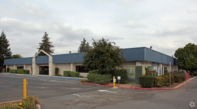
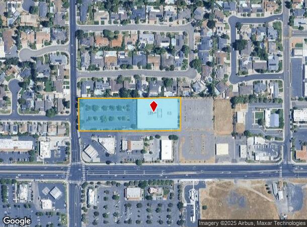
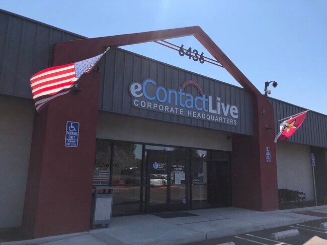
Property Record
6436 Oakdale Rd, Riverbank, CA 95367

NEARBY LISTINGS FOR SALE OR LEASE
-
-
View all Riverbank listings for sale on LoopNet.com
Property Detail
6436 Oakdale Rd
Modesto, CA
Parcel Map
075-26-40
PARCEL BOOK A PAGE 41 PARCEL 19
Officebuilding
Stanislaus
X
California
06077C0830F
a
2025
2.84 AC
2025
Modesto
000302
Stockton/Modesto
42,000 SF
DEMOGRAPHICS near 6436 Oakdale Rd
1 Mile
3 Mile
5 Mile
2024 Total Population
11,231
34,797
132,099
2029 Population
11,186
34,810
132,831
Pop Growth 2024-2029
(0.40%)
+ 0.04%
+ 0.55%
Average Age
37
37
38
2024 Total Households
3,389
10,786
44,684
HH Growth 2024-2029
(0.41%)
+ 0.04%
+ 0.53%
Median Household Inc
$79,680
$90,282
$85,502
Avg Household Size
3.30
3.20
2.90
2024 Avg HH Vehicles
2.00
2.00
2.00
Median Home Value
$440,109
$431,504
$434,459
Median Year Built
1992
1992
1983
Nearby Places
- Restaurants
- Banks
- Shops
- Fitness
- Groceries
PUBLIC TRANSPORTATION
COMMUTER RAIL
Modesto (San Joaquins - Amtrak)
DRIVE
WALK
Distance
Modesto (San Joaquins - Amtrak)
13 min
7.3 mi
AIRPORT
Stockton Metro
DRIVE
WALK
Distance
Stockton Metro
37 min
26.3 mi
Freight Ports
Port of Stockton
DRIVE
WALK
Distance
Port of Stockton
46 min
34.8 mi
SALE & LEASE HISTORY
LISTING DATE
SALE/LEASE

Sep 25, 2016
For Lease
Oct 27, 2016
For Lease
Jun 26, 2018
For Lease
Aug 27, 2024
For Sale
Aug 25, 2020
For Sale
Apr 30, 2024
For Lease
Nearby Properties
Address
Land Use
TOTAL SIZE
Lot Size
Zoning
Address
Land Use
TOTAL SIZE
Lot Size
Zoning
15.68 AC
RIVPD
Address
Land Use
TOTAL SIZE
Lot Size
Zoning
186,665 SF
10.22 AC
Address
Land Use
TOTAL SIZE
Lot Size
Zoning
123,575 SF
10 AC
PC
Address
Land Use
TOTAL SIZE
Lot Size
Zoning
60,156 SF
16.20 AC
Address
Land Use
TOTAL SIZE
Lot Size
Zoning
72,338 SF
5.98 AC
RIVC1
Address
Land Use
TOTAL SIZE
Lot Size
Zoning
140,669 SF
10.96 AC
PC
Address
Land Use
TOTAL SIZE
Lot Size
Zoning
47,760 SF
128 AC
Address
Land Use
TOTAL SIZE
Lot Size
Zoning
77,578 SF
7.93 AC
Address
Land Use
TOTAL SIZE
Lot Size
Zoning
56,265 SF
4.94 AC
MODPD
Address
Land Use
TOTAL SIZE
Lot Size
Zoning
83,987 SF
4.59 AC
RIVR3
Address
Land Use
TOTAL SIZE
Lot Size
Zoning
88,274 SF
6.32 AC
PC
Address
Land Use
TOTAL SIZE
Lot Size
Zoning
27,182 SF
3.57 AC
COUA2
Address
Land Use
TOTAL SIZE
Lot Size
Zoning
28,560 SF
9.62 AC
Address
Land Use
TOTAL SIZE
Lot Size
Zoning
24,829 SF
4.60 AC
COUH1
Address
Land Use
TOTAL SIZE
Lot Size
Zoning
36,817 SF
4.51 AC
Address
Land Use
TOTAL SIZE
Lot Size
Zoning
85,218 SF
3.51 AC
Address
Land Use
TOTAL SIZE
Lot Size
Zoning
57,760 SF
4.89 AC
PC
Address
Land Use
TOTAL SIZE
Lot Size
Zoning
131.20 AC
Address
Land Use
TOTAL SIZE
Lot Size
Zoning
465,061 SF
26.66 AC
CERM1
Address
Land Use
TOTAL SIZE
Lot Size
Zoning
227,470 SF
13.84 AC
Address
Land Use
TOTAL SIZE
Lot Size
Zoning
2,201 SF
0.61 AC
Address
Land Use
TOTAL SIZE
Lot Size
Zoning
41,698 SF
5.17 AC
Address
Land Use
TOTAL SIZE
Lot Size
Zoning
369.73 AC
Address
Land Use
TOTAL SIZE
Lot Size
Zoning
1,304 SF
57.16 AC
A240
Address
Land Use
TOTAL SIZE
Lot Size
Zoning
201,657 SF
8.53 AC
Address
Land Use
TOTAL SIZE
Lot Size
Zoning
20,623 SF
18.05 AC
Address
Land Use
TOTAL SIZE
Lot Size
Zoning
71,339 SF
4.26 AC
R3
Address
Land Use
TOTAL SIZE
Lot Size
Zoning
148,750 SF
11.88 AC
Address
Land Use
TOTAL SIZE
Lot Size
Zoning
1,620 SF
299.40 AC
A240
The World's #1 Commercial Real Estate Marketplace
Connect with us
© 2025 CoStar Group
The information above has been obtained from sources believed reliable. While we do not doubt its accuracy we have not verified it and make no guarantee, warranty or representation about it. It is your responsibility to independently confirm its accuracy and completeness. Any projections, opinions, assumptions, or estimates used are for example only and do not represent the current or future performance of the property. The value of this transaction to you depends on tax and other factors which should be evaluated by your tax, financial, and legal advisors. You and your advisors should conduct a careful, independent investigation of the property to determine to your satisfaction the suitability of the property for your needs.