Property Record
6438 Ga Highway 40 E, Kingsland, GA 31548
NEARBY LISTINGS FOR SALE OR LEASE
Property Detail
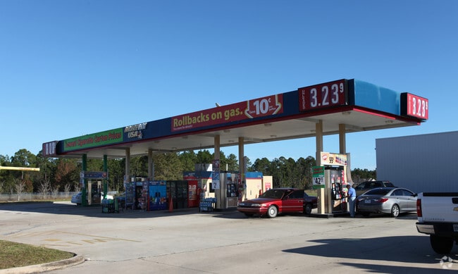
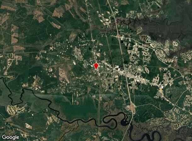
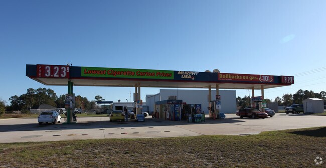
6438 Ga Highway 40 E
St. Marys, GA
COMM (GAS)/L HWY 40 (ADJ WAL-MART)
121-008-001
Camden
Commercialnec
Georgia
2025
1.17 AC
2025
Brunswick/Kingsland
010304
Other Market Areas
1,350 SF
DEMOGRAPHICS near 6438 Ga Highway 40 E
1 Mile
3 Mile
5 Mile
2024 Total Population
1,794
22,441
40,361
2029 Population
2,013
24,616
44,226
Pop Growth 2024-2029
+ 12.21%
+ 9.69%
+ 9.58%
Average Age
34
37
36
2024 Total Households
672
8,531
14,616
HH Growth 2024-2029
+ 12.35%
+ 9.82%
+ 9.76%
Median Household Inc
$55,937
$72,210
$64,123
Avg Household Size
2.60
2.60
2.60
2024 Avg HH Vehicles
2.00
2.00
2.00
Median Home Value
$193,536
$238,257
$223,955
Median Year Built
1997
1999
1996
Nearby Places
Map Layers
Map Styles
 Street
 Aerial
- Restaurants
- Banks
- Shops
- Fitness
- Groceries
PUBLIC TRANSPORTATION
AIRPORT
Jacksonville International
DRIVE
WALK
Distance
Jacksonville International
35 min
25.6 mi
Freight Ports
Georgia Ports - Brunswick
DRIVE
WALK
Distance
Georgia Ports - Brunswick
41 min
31.0 mi
Nearby Properties
Address
Land Use
TOTAL SIZE
Lot Size
Zoning
Address
Land Use
TOTAL SIZE
Lot Size
Zoning
184,547 SF
34.90 AC
R-1
Address
Land Use
TOTAL SIZE
Lot Size
Zoning
94,156 SF
74.30 AC
PD/R-1
Address
Land Use
TOTAL SIZE
Lot Size
Zoning
144,338 SF
35 AC
R-1
Address
Land Use
TOTAL SIZE
Lot Size
Zoning
79,447 SF
25 AC
PD/R-1
Address
Land Use
TOTAL SIZE
Lot Size
Zoning
80,714 SF
26.12 AC
R1
Address
Land Use
TOTAL SIZE
Lot Size
Zoning
76,769 SF
26 AC
R-1
Address
Land Use
TOTAL SIZE
Lot Size
Zoning
3,879 SF
10.72 AC
PD/R-3
Address
Land Use
TOTAL SIZE
Lot Size
Zoning
8,544 SF
18.64 AC
C2
Address
Land Use
TOTAL SIZE
Lot Size
Zoning
139,255 SF
16.27 AC
I-L
Address
Land Use
TOTAL SIZE
Lot Size
Zoning
15,590 SF
0.71 AC
C-4
Address
Land Use
TOTAL SIZE
Lot Size
Zoning
51,948 SF
2.08 AC
C-4
Address
Land Use
TOTAL SIZE
Lot Size
Zoning
55,497 SF
1.68 AC
C-4
Address
Land Use
TOTAL SIZE
Lot Size
Zoning
16,768 SF
8.96 AC
R-3
Address
Land Use
TOTAL SIZE
Lot Size
Zoning
9,530 SF
10.71 AC
PD/R-3
Address
Land Use
TOTAL SIZE
Lot Size
Zoning
3,712 SF
4.12 AC
PD/C-2
Address
Land Use
TOTAL SIZE
Lot Size
Zoning
49,008 SF
1.61 AC
C-4
Address
Land Use
TOTAL SIZE
Lot Size
Zoning
66,000 SF
3.72 AC
R-3
Address
Land Use
TOTAL SIZE
Lot Size
Zoning
22,046 SF
4.50 AC
R-1
Address
Land Use
TOTAL SIZE
Lot Size
Zoning
19,600 SF
1.51 AC
C-4
Address
Land Use
TOTAL SIZE
Lot Size
Zoning
32,108 SF
1.23 AC
C-4
Address
Land Use
TOTAL SIZE
Lot Size
Zoning
43,213 SF
1.73 AC
C-4
Address
Land Use
TOTAL SIZE
Lot Size
Zoning
10,496 SF
20 AC
C-4
Address
Land Use
TOTAL SIZE
Lot Size
Zoning
25 AC
R-1
Address
Land Use
TOTAL SIZE
Lot Size
Zoning
22,900 SF
3 AC
C-4
Address
Land Use
TOTAL SIZE
Lot Size
Zoning
7,620 SF
5 AC
C-4
Address
Land Use
TOTAL SIZE
Lot Size
Zoning
11,408 SF
6.37 AC
I-G
Address
Land Use
TOTAL SIZE
Lot Size
Zoning
2,224 SF
16.43 AC
PD/R-3
Address
Land Use
TOTAL SIZE
Lot Size
Zoning
22,932 SF
11.78 AC
PD/R-1
Address
Land Use
TOTAL SIZE
Lot Size
Zoning
16,838 SF
3.02 AC
C2
Address
Land Use
TOTAL SIZE
Lot Size
Zoning
35,169 SF
1.72 AC
C-4
The World's #1 Commercial Real Estate Marketplace
Connect with us
© 2025 CoStar Group
The information above has been obtained from sources believed reliable. While we do not doubt its accuracy we have not verified it and make no guarantee, warranty or representation about it. It is your responsibility to independently confirm its accuracy and completeness. Any projections, opinions, assumptions, or estimates used are for example only and do not represent the current or future performance of the property. The value of this transaction to you depends on tax and other factors which should be evaluated by your tax, financial, and legal advisors. You and your advisors should conduct a careful, independent investigation of the property to determine to your satisfaction the suitability of the property for your needs.