Property Record
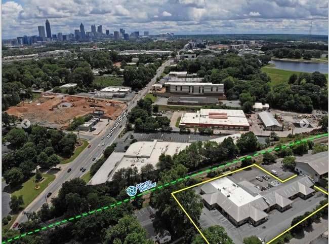
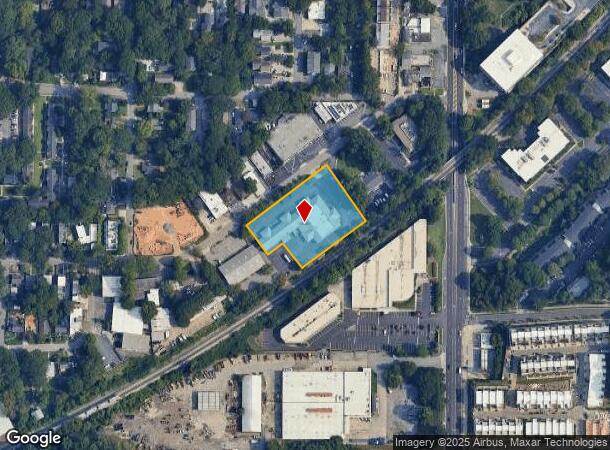
644 Antone St Nw, Atlanta, GA 30318
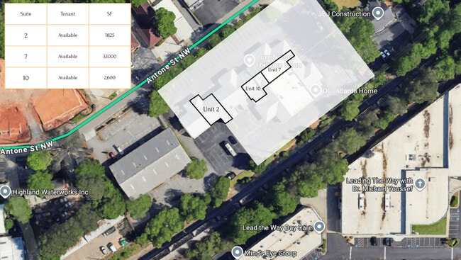
Current Lease Availabilities
NEARBY LISTINGS FOR SALE OR LEASE
Property Detail
644 Antone St Nw
Atlanta-Sandy Springs-Roswell, GA
John Ayers
17-0152-0007-083-9
KA ANTONE NORTHWEST BUSINESS FLD CK 4/21/21; CLOSE PERMIT COMPL
Officebuilding
Fulton
X
Georgia
13121C0241F
1
2024
1.45 AC
2025
Northside Dr/Georgia Tech
008905
Atlanta
22,190 SF
DEMOGRAPHICS near 644 Antone St Nw
1 Mile
3 Mile
5 Mile
2024 Total Population
18,449
159,733
378,845
2029 Population
18,846
166,129
392,837
Pop Growth 2024-2029
+ 2.15%
+ 4.00%
+ 3.69%
Average Age
33
36
37
2024 Total Households
10,872
79,533
184,419
HH Growth 2024-2029
+ 2.29%
+ 4.31%
+ 3.95%
Median Household Inc
$89,147
$89,632
$85,945
Avg Household Size
1.60
1.80
1.90
2024 Avg HH Vehicles
1.00
1.00
1.00
Median Home Value
$477,110
$521,962
$512,340
Median Year Built
2003
1998
1994
Nearby Places
- Restaurants
- Banks
- Shops
- Fitness
- Groceries
PUBLIC TRANSPORTATION
AIRPORT
Hartsfield - Jackson Atlanta International
DRIVE
WALK
Distance
Hartsfield - Jackson Atlanta International
23 min
14.2 mi
Nearby Properties
Address
Land Use
TOTAL SIZE
Lot Size
Zoning
Address
Land Use
TOTAL SIZE
Lot Size
Zoning
19.94 AC
SPI1
Address
Land Use
TOTAL SIZE
Lot Size
Zoning
1,585,451 SF
1.97 AC
SPI2
Address
Land Use
TOTAL SIZE
Lot Size
Zoning
9.80 AC
C5
Address
Land Use
TOTAL SIZE
Lot Size
Zoning
179.40 AC
R4
Address
Land Use
TOTAL SIZE
Lot Size
Zoning
9 AC
C5
Address
Land Use
TOTAL SIZE
Lot Size
Zoning
10.27 AC
C5
Address
Land Use
TOTAL SIZE
Lot Size
Zoning
1,039,831 SF
0.31 AC
C4
Address
Land Use
TOTAL SIZE
Lot Size
Zoning
1,227,912 SF
2.15 AC
SPI4
Address
Land Use
TOTAL SIZE
Lot Size
Zoning
1,736,017 SF
3.63 AC
SPI2
Address
Land Use
TOTAL SIZE
Lot Size
Zoning
2,044,200 SF
9.16 AC
C3
Address
Land Use
TOTAL SIZE
Lot Size
Zoning
1,300,309 SF
4.81 AC
SPI1
Address
Land Use
TOTAL SIZE
Lot Size
Zoning
61.57 AC
C5
Address
Land Use
TOTAL SIZE
Lot Size
Zoning
1,116,157 SF
1.48 AC
SPI3
Address
Land Use
TOTAL SIZE
Lot Size
Zoning
1,467,469 SF
0.07 AC
C4
Address
Land Use
TOTAL SIZE
Lot Size
Zoning
903,671 SF
1 AC
C3
Address
Land Use
TOTAL SIZE
Lot Size
Zoning
10,954,869 SF
28.88 AC
C3
Address
Land Use
TOTAL SIZE
Lot Size
Zoning
1,646,011 SF
3.74 AC
SPI4
Address
Land Use
TOTAL SIZE
Lot Size
Zoning
342,275 SF
0.70 AC
SPI3
Address
Land Use
TOTAL SIZE
Lot Size
Zoning
903,732 SF
0.34 AC
SPI1
Address
Land Use
TOTAL SIZE
Lot Size
Zoning
1,314,183 SF
2.61 AC
SPI1
Address
Land Use
TOTAL SIZE
Lot Size
Zoning
2,577,342 SF
2.04 AC
SPI1
Address
Land Use
TOTAL SIZE
Lot Size
Zoning
1,356,182 SF
2.52 AC
SPI4
Address
Land Use
TOTAL SIZE
Lot Size
Zoning
13,340,229 SF
3.68 AC
SPI1
Address
Land Use
TOTAL SIZE
Lot Size
Zoning
415,551 SF
1.13 AC
C4
Address
Land Use
TOTAL SIZE
Lot Size
Zoning
628,608 SF
0.39 AC
SPI4
Address
Land Use
TOTAL SIZE
Lot Size
Zoning
883,867 SF
2.71 AC
C1
Address
Land Use
TOTAL SIZE
Lot Size
Zoning
7,420 SF
0.13 AC
RG6
Address
Land Use
TOTAL SIZE
Lot Size
Zoning
899,982 SF
2.91 AC
C4
Address
Land Use
TOTAL SIZE
Lot Size
Zoning
687,016 SF
4.21 AC
R4
Address
Land Use
TOTAL SIZE
Lot Size
Zoning
787,339 SF
1.16 AC
SPI4
The World's #1 Commercial Real Estate Marketplace
Connect with us
© 2025 CoStar Group
The information above has been obtained from sources believed reliable. While we do not doubt its accuracy we have not verified it and make no guarantee, warranty or representation about it. It is your responsibility to independently confirm its accuracy and completeness. Any projections, opinions, assumptions, or estimates used are for example only and do not represent the current or future performance of the property. The value of this transaction to you depends on tax and other factors which should be evaluated by your tax, financial, and legal advisors. You and your advisors should conduct a careful, independent investigation of the property to determine to your satisfaction the suitability of the property for your needs.