Property Record
644 Cesery Blvd, Jacksonville, FL 32211


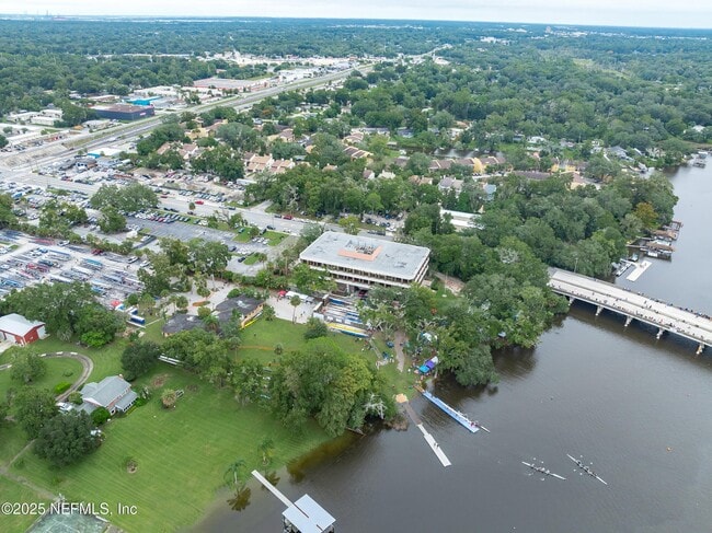

This Property Is For Sale
Current Lease Availabilities
Property Detail
644 Cesery Blvd
129366-0000
41-2S-27E 3.3 F RICHARD GRANT PT RECD O/R 20906-1144
Officebuilding
Duval
CRO
Florida
AE The base floodplain where base flood elevations are provided. AE Zones are now used on new format FIRMs instead of A1-A30 Zones.
10
2025
3.39 AC
2026
Southside
015501
Jacksonville (Florida)
31,883 SF
Jacksonville, FL
NEARBY LISTINGS FOR SALE OR LEASE
DEMOGRAPHICS near 644 Cesery Blvd
1 mile
3 mile
5 mile
2025 Total Population
10,462
95,412
226,816
2030 Population
11,046
101,213
241,400
Pop Growth 2025-2030
+ 5.58%
+ 6.08%
+ 6.43%
Average Age
39
38
39
2025 Total Households
4,454
37,990
93,024
HH Growth 2025-2030
+ 5.75%
+ 6.38%
+ 6.85%
Median Household Inc
$57,793
$56,164
$55,600
Avg Household Size
2.30
2.40
2.30
2025 Avg HH Vehicles
2.00
2.00
1.00
Median Home Value
$254,951
$256,861
$270,517
Median Year Built
1965
1970
1974
Nearby Places
Map Layers
Map Styles
 Street
 Aerial
Layers
 Traffic
 Biking
Places
Listings with unknown addresses are not visible on the map
- Restaurants
- Banks
- Shops
- Fitness
- Groceries
PUBLIC TRANSPORTATION
COMMUTER RAIL
Jacksonville (Silver Meteor - Amtrak, Silver Star - Amtrak)
Drive
Walk
Distance
Jacksonville (Silver Meteor - Amtrak, Silver Star - Amtrak)
17 min
10.0 mi
AIRPORT
Jacksonville International
Drive
Walk
Distance
Jacksonville International
29 min
18.7 mi
Freight Ports
Jacksonville Port
Drive
Walk
Distance
Jacksonville Port
10 min
5.5 mi
Nearby Properties
Address
Land Use
TOTAL SIZE
Lot Size
Zoning
Address
Land Use
TOTAL SIZE
Lot Size
Zoning
1,150,143 SF
43.90 AC
CCBD
Address
Land Use
TOTAL SIZE
Lot Size
Zoning
1,146,106 SF
206.66 AC
PBF-2
Address
Land Use
TOTAL SIZE
Lot Size
Zoning
875,866 SF
22.33 AC
PBF-3
Address
Land Use
TOTAL SIZE
Lot Size
Zoning
565,202 SF
33.92 AC
RMD-D
Address
Land Use
TOTAL SIZE
Lot Size
Zoning
194,877 SF
11.64 AC
CCBD
Address
Land Use
TOTAL SIZE
Lot Size
Zoning
557,032 SF
40.06 AC
PUD
Address
Land Use
TOTAL SIZE
Lot Size
Zoning
270,000 SF
8.90 AC
PUD
Address
Land Use
TOTAL SIZE
Lot Size
Zoning
229,284 SF
7.24 AC
PUD
Address
Land Use
TOTAL SIZE
Lot Size
Zoning
203,763 SF
9.97 AC
PUD
Address
Land Use
TOTAL SIZE
Lot Size
Zoning
308,517 SF
19.55 AC
PUD
Address
Land Use
TOTAL SIZE
Lot Size
Zoning
488,100 SF
35.32 AC
CRO
Address
Land Use
TOTAL SIZE
Lot Size
Zoning
430,668 SF
27.20 AC
RMD-D
Address
Land Use
TOTAL SIZE
Lot Size
Zoning
323,318 SF
19.24 AC
PUD
Address
Land Use
TOTAL SIZE
Lot Size
Zoning
410,225 SF
22.11 AC
PUD
Address
Land Use
TOTAL SIZE
Lot Size
Zoning
304,461 SF
62.44 AC
PBF-2
Address
Land Use
TOTAL SIZE
Lot Size
Zoning
93,059 SF
8.54 AC
CCG-2
Address
Land Use
TOTAL SIZE
Lot Size
Zoning
302,406 SF
20.54 AC
RMD-D
Address
Land Use
TOTAL SIZE
Lot Size
Zoning
394,122 SF
17.19 AC
RMD-D
Address
Land Use
TOTAL SIZE
Lot Size
Zoning
300,360 SF
14.44 AC
RMD-C
Address
Land Use
TOTAL SIZE
Lot Size
Zoning
328,457 SF
23.99 AC
RMD-D
Address
Land Use
TOTAL SIZE
Lot Size
Zoning
487,388 SF
28.28 AC
PUD
Address
Land Use
TOTAL SIZE
Lot Size
Zoning
210,913 SF
10.32 AC
PUD
Address
Land Use
TOTAL SIZE
Lot Size
Zoning
184,221 SF
12.05 AC
PUD
Address
Land Use
TOTAL SIZE
Lot Size
Zoning
226,323 SF
8.45 AC
PUD
Address
Land Use
TOTAL SIZE
Lot Size
Zoning
225,282 SF
15.36 AC
RMD-D
Address
Land Use
TOTAL SIZE
Lot Size
Zoning
275,005 SF
28.48 AC
PUD
Address
Land Use
TOTAL SIZE
Lot Size
Zoning
172,591 SF
8.40 AC
CRO
Address
Land Use
TOTAL SIZE
Lot Size
Zoning
164,330 SF
9.04 AC
PUD
Address
Land Use
TOTAL SIZE
Lot Size
Zoning
150,073 SF
11.23 AC
CCG-1
Address
Land Use
TOTAL SIZE
Lot Size
Zoning
604,760 SF
11.06 AC
IW
The World's #1 Commercial Real Estate Marketplace
Connect with us
© 2026 CoStar Group
The information above has been obtained from sources believed reliable. While we do not doubt its accuracy we have not verified it and make no guarantee, warranty or representation about it. It is your responsibility to independently confirm its accuracy and completeness. Any projections, opinions, assumptions, or estimates used are for example only and do not represent the current or future performance of the property. The value of this transaction to you depends on tax and other factors which should be evaluated by your tax, financial, and legal advisors. You and your advisors should conduct a careful, independent investigation of the property to determine to your satisfaction the suitability of the property for your needs.