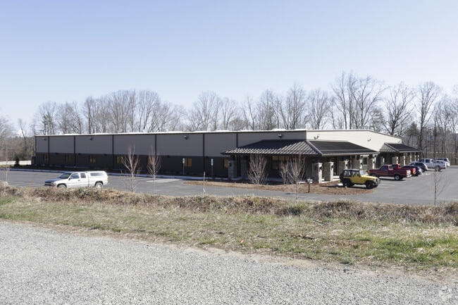
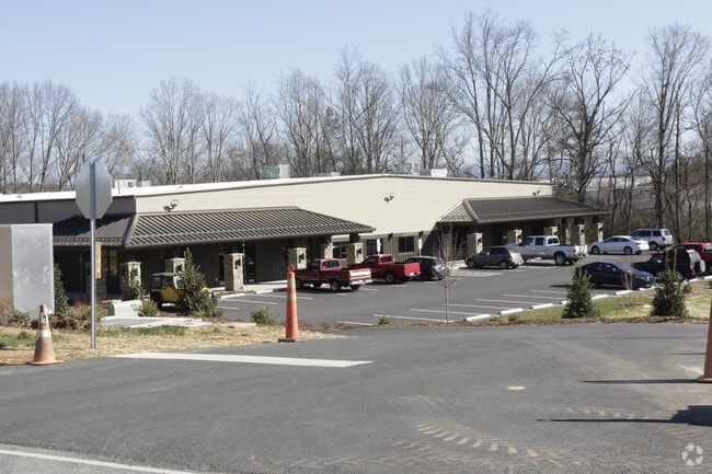
Property Record
644 Fanning Fields Rd, Mills River, NC 28759

Property Detail
644 Fanning Fields Rd
1018715
LOT # TR E BROADPOINTE CTR
Industrialgeneral
HENDERSON
1018715~MR
North Carolina
B and X Area of moderate flood hazard, usually the area between the limits of the 100-year and 500-year floods.
464
2025
9.78 AC
2025
Henderson County
930701
Asheville
31,448 SF
Asheville, NC
NEARBY LISTINGS FOR SALE OR LEASE
DEMOGRAPHICS near 644 Fanning Fields Rd
1 mile
3 mile
5 mile
2025 Total Population
1,021
16,500
50,168
2030 Population
1,070
16,990
51,667
Pop Growth 2025-2030
+ 4.80%
+ 2.97%
+ 2.99%
Average Age
43
43
43
2025 Total Households
396
6,716
20,871
HH Growth 2025-2030
+ 4.80%
+ 3.04%
+ 2.96%
Median Household Inc
$87,804
$81,173
$80,907
Avg Household Size
2.60
2.40
2.40
2025 Avg HH Vehicles
2.00
2.00
2.00
Median Home Value
$356,999
$388,409
$404,614
Median Year Built
2001
1996
1997
Nearby Places
Map Layers
Map Styles
 Street
 Aerial
Transit
 Traffic
 Biking
Places
Listings with unknown addresses are not visible on the map
- Restaurants
- Banks
- Shops
- Fitness
- Groceries
PUBLIC TRANSPORTATION
AIRPORT
Asheville Regional
Drive
Walk
Distance
Asheville Regional
4 min
2.4 mi
Freight Ports
North Charleston Terminal
Drive
Walk
Distance
North Charleston Terminal
276 min
244.7 mi
Nearby Properties
Address
Land Use
TOTAL SIZE
Lot Size
Zoning
Address
Land Use
TOTAL SIZE
Lot Size
Zoning
107,063 SF
567.34 AC
AI
Address
Land Use
TOTAL SIZE
Lot Size
Zoning
281,505 SF
38.35 AC
10000070~M
Address
Land Use
TOTAL SIZE
Lot Size
Zoning
85,103 SF
11.69 AC
RES EXP
Address
Land Use
TOTAL SIZE
Lot Size
Zoning
107,408 SF
21.92 AC
R-3
Address
Land Use
TOTAL SIZE
Lot Size
Zoning
198,705 SF
32.46 AC
HB
Address
Land Use
TOTAL SIZE
Lot Size
Zoning
481,731 SF
86.32 AC
1009658~I
Address
Land Use
TOTAL SIZE
Lot Size
Zoning
21.70 AC
10005690~M
Address
Land Use
TOTAL SIZE
Lot Size
Zoning
4,839 SF
9.46 AC
10002512~C
Address
Land Use
TOTAL SIZE
Lot Size
Zoning
92,772 SF
12.30 AC
R-2
Address
Land Use
TOTAL SIZE
Lot Size
Zoning
365,659 SF
38.28 AC
9958527~M-
Address
Land Use
TOTAL SIZE
Lot Size
Zoning
86,393 SF
15.44 AC
PS
Address
Land Use
TOTAL SIZE
Lot Size
Zoning
14,704 SF
3.31 AC
10007972~M
Address
Land Use
TOTAL SIZE
Lot Size
Zoning
39.98 AC
10007822~M
Address
Land Use
TOTAL SIZE
Lot Size
Zoning
107,698 SF
25.53 AC
PS
Address
Land Use
TOTAL SIZE
Lot Size
Zoning
76,255 SF
10.55 AC
EMP
Address
Land Use
TOTAL SIZE
Lot Size
Zoning
3,000 SF
48.13 AC
10010496~M
Address
Land Use
TOTAL SIZE
Lot Size
Zoning
13,525 SF
1.84 AC
LODG EXP
Address
Land Use
TOTAL SIZE
Lot Size
Zoning
15,493 SF
2.01 AC
EMP
Address
Land Use
TOTAL SIZE
Lot Size
Zoning
28,183 SF
5.88 AC
10010086~C
Address
Land Use
TOTAL SIZE
Lot Size
Zoning
44,384 SF
9.54 AC
R-3
Address
Land Use
TOTAL SIZE
Lot Size
Zoning
77,152 SF
13.84 AC
9933538~MR
Address
Land Use
TOTAL SIZE
Lot Size
Zoning
112,100 SF
14.22 AC
9975597~MR
Address
Land Use
TOTAL SIZE
Lot Size
Zoning
14,024 SF
2 AC
HB
Address
Land Use
TOTAL SIZE
Lot Size
Zoning
83,741 SF
24.39 AC
9959040~MR
Address
Land Use
TOTAL SIZE
Lot Size
Zoning
178,825 SF
25.05 AC
1016341~MR
Address
Land Use
TOTAL SIZE
Lot Size
Zoning
237,185 SF
17.57 AC
9962196~MR
Address
Land Use
TOTAL SIZE
Lot Size
Zoning
51,090 SF
5.18 AC
1007612~C-
Address
Land Use
TOTAL SIZE
Lot Size
Zoning
345,310 SF
16.60 AC
R-2
Address
Land Use
TOTAL SIZE
Lot Size
Zoning
3,190 SF
21.46 AC
1016340~MR
Address
Land Use
TOTAL SIZE
Lot Size
Zoning
22,929 SF
330.68 AC
10011861~R
The World's #1 Commercial Real Estate Marketplace
Connect with us
© 2026 CoStar Group
The information above has been obtained from sources believed reliable. While we do not doubt its accuracy we have not verified it and make no guarantee, warranty or representation about it. It is your responsibility to independently confirm its accuracy and completeness. Any projections, opinions, assumptions, or estimates used are for example only and do not represent the current or future performance of the property. The value of this transaction to you depends on tax and other factors which should be evaluated by your tax, financial, and legal advisors. You and your advisors should conduct a careful, independent investigation of the property to determine to your satisfaction the suitability of the property for your needs.