Property Record
644 Ridge Rd, Webster, NY 14580
NEARBY LISTINGS FOR SALE OR LEASE
Property Detail
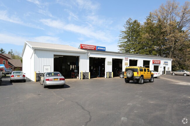
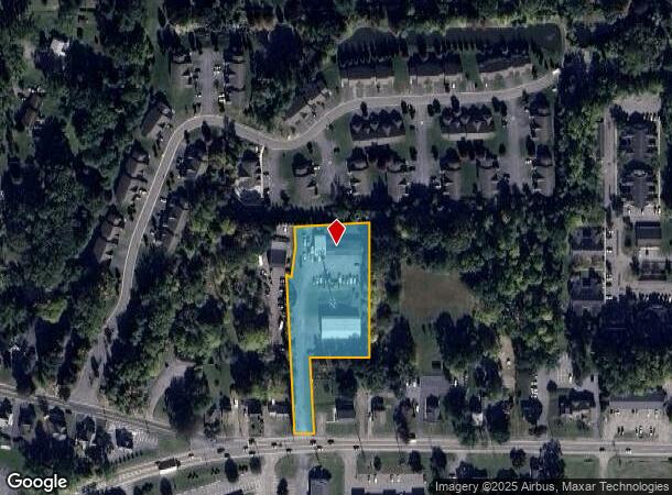
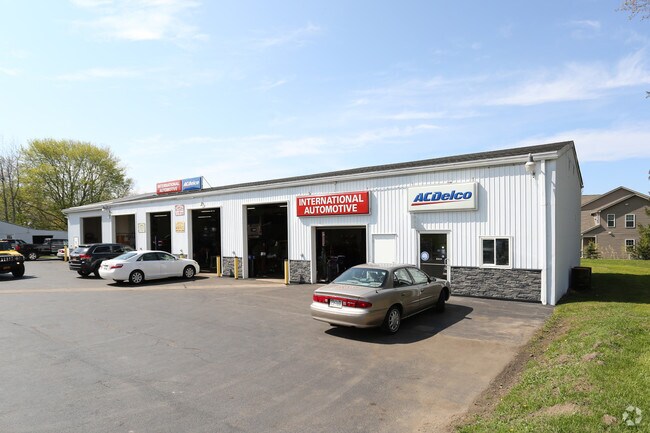
644 Ridge Rd
265489-078-200-0001-031-210
L60 T13 R4 KETCHAM PT 3,4,5 84-20 DEED MAP 9720-374
Autorepair
Monroe
X
New York
36055C0228G
31.210
2025
1.86 AC
2024
Northeast
011207
Rochester
4,496 SF
Rochester, NY
DEMOGRAPHICS near 644 Ridge Rd
1 Mile
3 Mile
5 Mile
2024 Total Population
6,856
44,741
127,406
2029 Population
6,713
44,155
125,479
Pop Growth 2024-2029
(2.09%)
(1.31%)
(1.51%)
Average Age
43
45
43
2024 Total Households
2,917
19,529
54,832
HH Growth 2024-2029
(2.16%)
(1.35%)
(1.58%)
Median Household Inc
$81,250
$85,292
$72,703
Avg Household Size
2.30
2.20
2.30
2024 Avg HH Vehicles
2.00
2.00
2.00
Median Home Value
$210,630
$225,763
$183,023
Median Year Built
1981
1981
1962
Nearby Places
- Restaurants
- Banks
- Shops
- Fitness
- Groceries
PUBLIC TRANSPORTATION
COMMUTER RAIL
DRIVE
WALK
Distance
14 min
7.9 mi
AIRPORT
Frederick Douglass/Greater Rochester International
DRIVE
WALK
Distance
Frederick Douglass/Greater Rochester International
24 min
13.1 mi
Nearby Properties
Address
Land Use
TOTAL SIZE
Lot Size
Zoning
Address
Land Use
TOTAL SIZE
Lot Size
Zoning
39.21 AC
Address
Land Use
TOTAL SIZE
Lot Size
Zoning
32,868 SF
46.85 AC
Address
Land Use
TOTAL SIZE
Lot Size
Zoning
278,538 SF
53.90 AC
09200
Address
Land Use
TOTAL SIZE
Lot Size
Zoning
168,660 SF
42.78 AC
Address
Land Use
TOTAL SIZE
Lot Size
Zoning
35,546 SF
34.12 AC
GB
Address
Land Use
TOTAL SIZE
Lot Size
Zoning
52,716 SF
10.72 AC
LLD
Address
Land Use
TOTAL SIZE
Lot Size
Zoning
48,000 SF
19.51 AC
03 - MULTI
Address
Land Use
TOTAL SIZE
Lot Size
Zoning
98,258 SF
28.47 AC
23550
Address
Land Use
TOTAL SIZE
Lot Size
Zoning
80,405 SF
15.14 AC
Address
Land Use
TOTAL SIZE
Lot Size
Zoning
2,617 SF
27.13 AC
Address
Land Use
TOTAL SIZE
Lot Size
Zoning
198,229 SF
22.75 AC
GB
Address
Land Use
TOTAL SIZE
Lot Size
Zoning
73,724 SF
11.79 AC
02 - SINGL
Address
Land Use
TOTAL SIZE
Lot Size
Zoning
3,121 SF
16.17 AC
MR
Address
Land Use
TOTAL SIZE
Lot Size
Zoning
7,424 SF
41.69 AC
Address
Land Use
TOTAL SIZE
Lot Size
Zoning
205,258 SF
40 AC
Address
Land Use
TOTAL SIZE
Lot Size
Zoning
11,862 SF
35.80 AC
26340
Address
Land Use
TOTAL SIZE
Lot Size
Zoning
97,055 SF
15.73 AC
Address
Land Use
TOTAL SIZE
Lot Size
Zoning
52,716 SF
7.57 AC
LLD
Address
Land Use
TOTAL SIZE
Lot Size
Zoning
118,000 SF
16.38 AC
GB
Address
Land Use
TOTAL SIZE
Lot Size
Zoning
67,158 SF
25.29 AC
R-1-20
Address
Land Use
TOTAL SIZE
Lot Size
Zoning
380,600 SF
44.14 AC
06 - INDUS
Address
Land Use
TOTAL SIZE
Lot Size
Zoning
18,832 SF
31.20 AC
09170
Address
Land Use
TOTAL SIZE
Lot Size
Zoning
93,520 SF
37.91 AC
Address
Land Use
TOTAL SIZE
Lot Size
Zoning
8,526 SF
26.46 AC
Address
Land Use
TOTAL SIZE
Lot Size
Zoning
Address
Land Use
TOTAL SIZE
Lot Size
Zoning
5,693 SF
17.28 AC
Address
Land Use
TOTAL SIZE
Lot Size
Zoning
127,521 SF
13.16 AC
Address
Land Use
TOTAL SIZE
Lot Size
Zoning
137,980 SF
18.21 AC
Address
Land Use
TOTAL SIZE
Lot Size
Zoning
82,349 SF
13.96 AC
Address
Land Use
TOTAL SIZE
Lot Size
Zoning
104,934 SF
17.03 AC
01 - NOT Z
The World's #1 Commercial Real Estate Marketplace
Connect with us
© 2025 CoStar Group
The information above has been obtained from sources believed reliable. While we do not doubt its accuracy we have not verified it and make no guarantee, warranty or representation about it. It is your responsibility to independently confirm its accuracy and completeness. Any projections, opinions, assumptions, or estimates used are for example only and do not represent the current or future performance of the property. The value of this transaction to you depends on tax and other factors which should be evaluated by your tax, financial, and legal advisors. You and your advisors should conduct a careful, independent investigation of the property to determine to your satisfaction the suitability of the property for your needs.