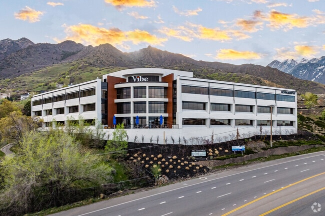
Property Record
6440 S Wasatch Blvd, Holladay, UT 84121
Current Lease Availabilities
NEARBY LISTINGS FOR SALE OR LEASE
Property Detail
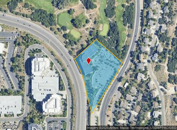
6440 S Wasatch Blvd
Salt Lake City, UT
Radius Curve
22-23-276-003-0000
BEG E 1678.34 FT & S 1346.02 FT FR N 1/4 COR SEC 23, T 2S, R1E, SLM; S 48^2941 E 356.02 FT; SWLY ALG A 1382.7 FT RADIUS CURVE TO R 187.01 FT; S 31^55 W 364.40 FT; SWLY ALGA 1482.70 FT RADIUS CURVE TO L 54.54 FT; N 15^5120 W 197.46 FT; NWLY ALG A 945
Officebuilding
Salt Lake
X
Utah
49035C0318G
54
2024
4.09 AC
2025
Central Valley East
110104
Salt Lake City
68,783 SF
DEMOGRAPHICS near 6440 S Wasatch Blvd
1 Mile
3 Mile
5 Mile
2024 Total Population
3,628
57,406
193,188
2029 Population
3,637
57,816
194,388
Pop Growth 2024-2029
+ 0.25%
+ 0.71%
+ 0.62%
Average Age
42
42
40
2024 Total Households
1,263
21,482
72,900
HH Growth 2024-2029
0.00%
+ 0.56%
+ 0.53%
Median Household Inc
$121,213
$106,220
$91,117
Avg Household Size
2.80
2.60
2.60
2024 Avg HH Vehicles
2.00
2.00
2.00
Median Home Value
$723,214
$691,378
$575,448
Median Year Built
1987
1975
1976
Nearby Places
Map Layers
Map Styles
 Street
 Aerial
- Restaurants
- Banks
- Shops
- Fitness
- Groceries
PUBLIC TRANSPORTATION
AIRPORT
Salt Lake City International
DRIVE
WALK
Distance
Salt Lake City International
25 min
20.1 mi
Provo Municipal
DRIVE
WALK
Distance
Provo Municipal
56 min
43.2 mi
Freight Ports
Port of Stockton
DRIVE
WALK
Distance
Port of Stockton
725 min
710.5 mi
Nearby Properties
Address
Land Use
TOTAL SIZE
Lot Size
Zoning
Address
Land Use
TOTAL SIZE
Lot Size
Zoning
257,906 SF
36.42 AC
1110
Address
Land Use
TOTAL SIZE
Lot Size
Zoning
186,717 SF
21.58 AC
RM
Address
Land Use
TOTAL SIZE
Lot Size
Zoning
133,669 SF
19.81 AC
R-M
Address
Land Use
TOTAL SIZE
Lot Size
Zoning
225,849 SF
16.36 AC
RM-ZC
Address
Land Use
TOTAL SIZE
Lot Size
Zoning
371,607 SF
10.77 AC
A-1
Address
Land Use
TOTAL SIZE
Lot Size
Zoning
241,418 SF
8.84 AC
ORD
Address
Land Use
TOTAL SIZE
Lot Size
Zoning
106,016 SF
32.73 AC
1108
Address
Land Use
TOTAL SIZE
Lot Size
Zoning
317,495 SF
2.75 AC
O-R-D
Address
Land Use
TOTAL SIZE
Lot Size
Zoning
433,385 SF
3.64 AC
R/M-U
Address
Land Use
TOTAL SIZE
Lot Size
Zoning
150,570 SF
12.76 AC
ORD
Address
Land Use
TOTAL SIZE
Lot Size
Zoning
71,504 SF
7.11 AC
R-1-10
Address
Land Use
TOTAL SIZE
Lot Size
Zoning
49,722 SF
7.59 AC
RM-ZC
Address
Land Use
TOTAL SIZE
Lot Size
Zoning
176,372 SF
3.68 AC
ORD
Address
Land Use
TOTAL SIZE
Lot Size
Zoning
152,184 SF
4.40 AC
ORD
Address
Land Use
TOTAL SIZE
Lot Size
Zoning
74,394 SF
9.27 AC
RM
Address
Land Use
TOTAL SIZE
Lot Size
Zoning
125,789 SF
24.19 AC
1110
Address
Land Use
TOTAL SIZE
Lot Size
Zoning
78,330 SF
3 AC
O-R-D
Address
Land Use
TOTAL SIZE
Lot Size
Zoning
105,015 SF
3.91 AC
O R D
Address
Land Use
TOTAL SIZE
Lot Size
Zoning
171,805 SF
3.95 AC
ORD
Address
Land Use
TOTAL SIZE
Lot Size
Zoning
75,638 SF
2.93 AC
RM-25
Address
Land Use
TOTAL SIZE
Lot Size
Zoning
128,678 SF
9.95 AC
C-2/ZC
Address
Land Use
TOTAL SIZE
Lot Size
Zoning
206,860 SF
3.57 AC
O-R-D
Address
Land Use
TOTAL SIZE
Lot Size
Zoning
47,785 SF
8.11 AC
P
Address
Land Use
TOTAL SIZE
Lot Size
Zoning
52,182 SF
5 AC
1108
Address
Land Use
TOTAL SIZE
Lot Size
Zoning
188,750 SF
1.01 AC
O-R-D
Address
Land Use
TOTAL SIZE
Lot Size
Zoning
181,772 SF
11.75 AC
C-D-C
Address
Land Use
TOTAL SIZE
Lot Size
Zoning
83,690 SF
3.67 AC
ORD
Address
Land Use
TOTAL SIZE
Lot Size
Zoning
177,585 SF
4.65 AC
O-R-D
Address
Land Use
TOTAL SIZE
Lot Size
Zoning
78,833 SF
5.19 AC
O-R-D
Address
Land Use
TOTAL SIZE
Lot Size
Zoning
185,522 SF
17.26 AC
C2/ZC
The World's #1 Commercial Real Estate Marketplace
Connect with us
© 2025 CoStar Group
The information above has been obtained from sources believed reliable. While we do not doubt its accuracy we have not verified it and make no guarantee, warranty or representation about it. It is your responsibility to independently confirm its accuracy and completeness. Any projections, opinions, assumptions, or estimates used are for example only and do not represent the current or future performance of the property. The value of this transaction to you depends on tax and other factors which should be evaluated by your tax, financial, and legal advisors. You and your advisors should conduct a careful, independent investigation of the property to determine to your satisfaction the suitability of the property for your needs.