Property Record
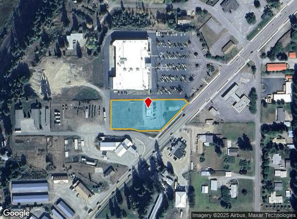
6442 Main St, Bonners Ferry, ID 83805
NEARBY LISTINGS FOR SALE OR LEASE
Property Detail
6442 Main St
Other Market Areas
Maxwells Acres
B066000101A0
LOT 1A MAXWELL ACRE TRACT - AMENDED SEC 33 T62N R1E
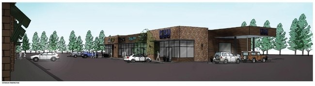
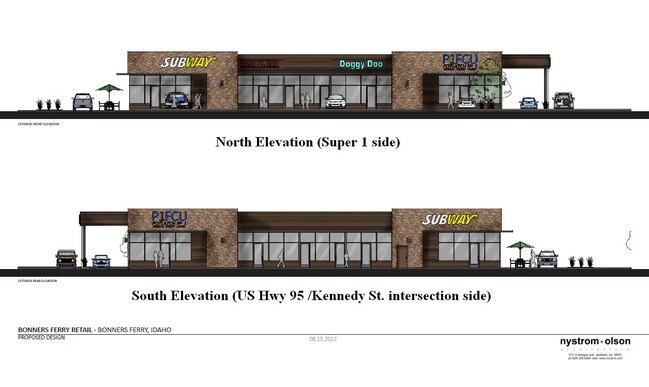
Restaurantdrivein
Boundary
2025
Idaho
2025
1a
970200
1.24 AC
1,560 SF
Idaho North Area
DEMOGRAPHICS near 6442 Main St
1 Mile
3 Mile
5 Mile
2024 Total Population
1,493
4,799
6,857
2029 Population
1,890
6,096
8,713
Pop Growth 2024-2029
+ 26.59%
+ 27.03%
+ 27.07%
Average Age
45
44
44
2024 Total Households
660
1,983
2,779
HH Growth 2024-2029
+ 26.06%
+ 26.58%
+ 26.56%
Median Household Inc
$37,999
$40,791
$44,386
Avg Household Size
2.30
2.40
2.40
2024 Avg HH Vehicles
2.00
2.00
2.00
Median Home Value
$326,562
$337,415
$343,370
Median Year Built
1979
1987
1989
Nearby Places
Map Layers
Map Styles
 Street
 Aerial
- Restaurants
- Banks
- Shops
- Fitness
- Groceries
SALE & LEASE HISTORY
LISTING DATE
SALE/LEASE

Sep 25, 2016
For Lease
Oct 12, 2017
For Lease
Nearby Properties
Address
Land Use
TOTAL SIZE
Lot Size
Zoning
Address
Land Use
TOTAL SIZE
Lot Size
Zoning
54,016 SF
4.67 AC
Address
Land Use
TOTAL SIZE
Lot Size
Zoning
33,840 SF
3.54 AC
Address
Land Use
TOTAL SIZE
Lot Size
Zoning
25,920 SF
4.01 AC
Address
Land Use
TOTAL SIZE
Lot Size
Zoning
Address
Land Use
TOTAL SIZE
Lot Size
Zoning
2,700 SF
22.62 AC
Address
Land Use
TOTAL SIZE
Lot Size
Zoning
384 SF
1.37 AC
Address
Land Use
TOTAL SIZE
Lot Size
Zoning
5,534 SF
0.58 AC
Address
Land Use
TOTAL SIZE
Lot Size
Zoning
13,802 SF
0.80 AC
Address
Land Use
TOTAL SIZE
Lot Size
Zoning
7,287 SF
0.94 AC
Address
Land Use
TOTAL SIZE
Lot Size
Zoning
6,120 SF
0.96 AC
Address
Land Use
TOTAL SIZE
Lot Size
Zoning
7,378 SF
0.77 AC
Address
Land Use
TOTAL SIZE
Lot Size
Zoning
6,104 SF
0.83 AC
Address
Land Use
TOTAL SIZE
Lot Size
Zoning
3,510 SF
0.63 AC
Address
Land Use
TOTAL SIZE
Lot Size
Zoning
20,000 SF
0.34 AC
Address
Land Use
TOTAL SIZE
Lot Size
Zoning
4,101 SF
0.47 AC
Address
Land Use
TOTAL SIZE
Lot Size
Zoning
4,446 SF
0.81 AC
Address
Land Use
TOTAL SIZE
Lot Size
Zoning
5,524 SF
1.41 AC
Address
Land Use
TOTAL SIZE
Lot Size
Zoning
9,060 SF
0.59 AC
Address
Land Use
TOTAL SIZE
Lot Size
Zoning
Address
Land Use
TOTAL SIZE
Lot Size
Zoning
12,000 SF
0.14 AC
Address
Land Use
TOTAL SIZE
Lot Size
Zoning
6,588 SF
1.71 AC
Address
Land Use
TOTAL SIZE
Lot Size
Zoning
18,084 SF
1.46 AC
Address
Land Use
TOTAL SIZE
Lot Size
Zoning
1.45 AC
Address
Land Use
TOTAL SIZE
Lot Size
Zoning
5,936 SF
0.53 AC
Address
Land Use
TOTAL SIZE
Lot Size
Zoning
89.05 AC
Address
Land Use
TOTAL SIZE
Lot Size
Zoning
0.50 AC
Address
Land Use
TOTAL SIZE
Lot Size
Zoning
7,360 SF
0.57 AC
Address
Land Use
TOTAL SIZE
Lot Size
Zoning
5,347 SF
0.29 AC
The World's #1 Commercial Real Estate Marketplace
Connect with us
© 2025 CoStar Group
The information above has been obtained from sources believed reliable. While we do not doubt its accuracy we have not verified it and make no guarantee, warranty or representation about it. It is your responsibility to independently confirm its accuracy and completeness. Any projections, opinions, assumptions, or estimates used are for example only and do not represent the current or future performance of the property. The value of this transaction to you depends on tax and other factors which should be evaluated by your tax, financial, and legal advisors. You and your advisors should conduct a careful, independent investigation of the property to determine to your satisfaction the suitability of the property for your needs.