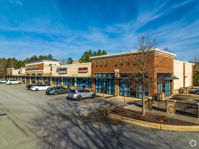
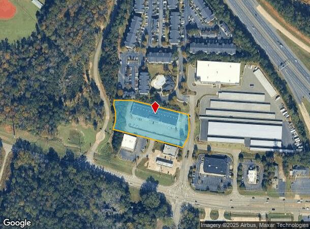
Property Record
6443 Zebulon Rd, Macon, GA 31220
NEARBY LISTINGS FOR SALE OR LEASE
-
-
View all Macon listings for lease on LoopNet.com
Property Detail
6443 Zebulon Rd
I005-0575
Bibb
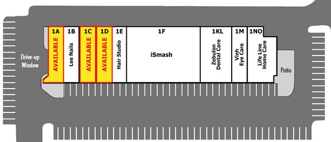
Stripcommercialcenter
Georgia
X
200&209
13207C0250E
2.37 AC
2025
Outlying Bibb County
2025
Atlanta
013409
Macon-Bibb County, GA
21,442 SF
DEMOGRAPHICS near 6443 Zebulon Rd
1 Mile
3 Mile
5 Mile
2024 Total Population
3,245
17,396
44,404
2029 Population
3,160
17,036
43,856
Pop Growth 2024-2029
(2.62%)
(2.07%)
(1.23%)
Average Age
40
41
40
2024 Total Households
1,230
6,950
18,395
HH Growth 2024-2029
(2.44%)
(2.00%)
(1.23%)
Median Household Inc
$67,011
$87,741
$82,905
Avg Household Size
2.50
2.40
2.40
2024 Avg HH Vehicles
2.00
2.00
2.00
Median Home Value
$219,047
$232,054
$232,386
Median Year Built
1993
1994
1991
Nearby Places
Map Layers
Map Styles
 Street
 Aerial
- Restaurants
- Banks
- Shops
- Fitness
- Groceries
SALE & LEASE HISTORY
LISTING DATE
SALE/LEASE

Sep 25, 2016
For Lease
May 31, 2018
For Sale
Mar 30, 2023
For Lease
Mar 19, 2018
For Sale
Jul 09, 2018
For Sale
Dec 06, 2022
For Sale
Nearby Properties
Address
Land Use
TOTAL SIZE
Lot Size
Zoning
Address
Land Use
TOTAL SIZE
Lot Size
Zoning
83,104 SF
20.39 AC
PDE
Address
Land Use
TOTAL SIZE
Lot Size
Zoning
5,684 SF
29.99 AC
PDE
Address
Land Use
TOTAL SIZE
Lot Size
Zoning
22,421 SF
13.60 AC
PDE
Address
Land Use
TOTAL SIZE
Lot Size
Zoning
98,912 SF
13.95 AC
PDE
Address
Land Use
TOTAL SIZE
Lot Size
Zoning
59,801 SF
28.03 AC
PDE
Address
Land Use
TOTAL SIZE
Lot Size
Zoning
5,270 SF
20 AC
Address
Land Use
TOTAL SIZE
Lot Size
Zoning
61,540 SF
130.80 AC
A
Address
Land Use
TOTAL SIZE
Lot Size
Zoning
214,685 SF
18.69 AC
C-2
Address
Land Use
TOTAL SIZE
Lot Size
Zoning
51,786 SF
21.05 AC
PDR
Address
Land Use
TOTAL SIZE
Lot Size
Zoning
20,544 SF
62.02 AC
A
Address
Land Use
TOTAL SIZE
Lot Size
Zoning
2,070 SF
24.17 AC
PDR
Address
Land Use
TOTAL SIZE
Lot Size
Zoning
3,025 SF
23.37 AC
R-3
Address
Land Use
TOTAL SIZE
Lot Size
Zoning
4,030 SF
11.99 AC
A
Address
Land Use
TOTAL SIZE
Lot Size
Zoning
211,781 SF
22.45 AC
PDE
Address
Land Use
TOTAL SIZE
Lot Size
Zoning
29,277 SF
15.01 AC
PDE
Address
Land Use
TOTAL SIZE
Lot Size
Zoning
2,854 SF
14.08 AC
PDR
Address
Land Use
TOTAL SIZE
Lot Size
Zoning
135,820 SF
20 AC
PDE
Address
Land Use
TOTAL SIZE
Lot Size
Zoning
10,500 SF
11.21 AC
PDE
Address
Land Use
TOTAL SIZE
Lot Size
Zoning
2,856 SF
20.50 AC
A
Address
Land Use
TOTAL SIZE
Lot Size
Zoning
67,883 SF
9.11 AC
PDE
Address
Land Use
TOTAL SIZE
Lot Size
Zoning
88,509 SF
10.61 AC
PDE
Address
Land Use
TOTAL SIZE
Lot Size
Zoning
62,676 SF
8.57 AC
PDE
Address
Land Use
TOTAL SIZE
Lot Size
Zoning
76,091 SF
36.14 AC
A
Address
Land Use
TOTAL SIZE
Lot Size
Zoning
54,465 SF
3.52 AC
PDE
Address
Land Use
TOTAL SIZE
Lot Size
Zoning
45,807 SF
6.50 AC
PDR
Address
Land Use
TOTAL SIZE
Lot Size
Zoning
15,040 SF
7.88 AC
PDE
Address
Land Use
TOTAL SIZE
Lot Size
Zoning
38,030 SF
5.27 AC
PDE
Address
Land Use
TOTAL SIZE
Lot Size
Zoning
18,532 SF
5.04 AC
PDR
Address
Land Use
TOTAL SIZE
Lot Size
Zoning
49,908 SF
3.05 AC
PDE
Address
Land Use
TOTAL SIZE
Lot Size
Zoning
63.99 AC
PDE
The World's #1 Commercial Real Estate Marketplace
Connect with us
© 2025 CoStar Group
The information above has been obtained from sources believed reliable. While we do not doubt its accuracy we have not verified it and make no guarantee, warranty or representation about it. It is your responsibility to independently confirm its accuracy and completeness. Any projections, opinions, assumptions, or estimates used are for example only and do not represent the current or future performance of the property. The value of this transaction to you depends on tax and other factors which should be evaluated by your tax, financial, and legal advisors. You and your advisors should conduct a careful, independent investigation of the property to determine to your satisfaction the suitability of the property for your needs.