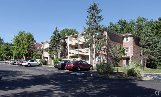
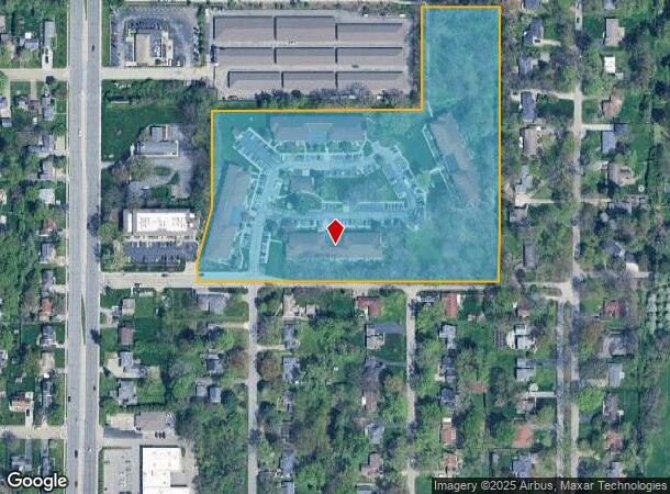
Property Record
6449 N Keystone Ave, Indianapolis, IN 46220

NEARBY LISTINGS FOR SALE OR LEASE
Property Detail
6449 N Keystone Ave
49-02-31-112-003.000-800
G 9.962 AC.
Apartment
Marion
X
Indiana
18097C0151G
9.96 AC
2023
Glendale
2024
Indianapolis
321400
Indianapolis-Carmel-Greenwood, IN
1,696 SF
DEMOGRAPHICS near 6449 N Keystone Ave
1 Mile
3 Mile
5 Mile
2024 Total Population
7,919
70,936
217,698
2029 Population
7,783
70,072
217,629
Pop Growth 2024-2029
(1.72%)
(1.22%)
(0.03%)
Average Age
40
41
39
2024 Total Households
3,907
33,244
95,885
HH Growth 2024-2029
(1.89%)
(1.33%)
(0.16%)
Median Household Inc
$93,504
$89,478
$62,783
Avg Household Size
2.00
2.10
2.20
2024 Avg HH Vehicles
2.00
2.00
2.00
Median Home Value
$261,446
$299,522
$253,567
Median Year Built
1957
1959
1966
Nearby Places
Map Layers
Map Styles
 Street
 Aerial
- Restaurants
- Banks
- Shops
- Fitness
- Groceries
PUBLIC TRANSPORTATION
COMMUTER RAIL
Indianapolis (Cardinal - Amtrak)
DRIVE
WALK
Distance
Indianapolis (Cardinal - Amtrak)
18 min
9.6 mi
AIRPORT
Indianapolis International
DRIVE
WALK
Distance
Indianapolis International
40 min
22.6 mi
Freight Ports
Port of Toledo
DRIVE
WALK
Distance
Port of Toledo
260 min
218.7 mi
Nearby Properties
Address
Land Use
TOTAL SIZE
Lot Size
Zoning
Address
Land Use
TOTAL SIZE
Lot Size
Zoning
4,146 SF
45.91 AC
ZO01
Address
Land Use
TOTAL SIZE
Lot Size
Zoning
315,968 SF
0.06 AC
ZO01
Address
Land Use
TOTAL SIZE
Lot Size
Zoning
345 SF
6.39 AC
ZO01
Address
Land Use
TOTAL SIZE
Lot Size
Zoning
8,157 SF
113.93 AC
ZO01
Address
Land Use
TOTAL SIZE
Lot Size
Zoning
5,149 SF
10.56 AC
ZO01
Address
Land Use
TOTAL SIZE
Lot Size
Zoning
143,890 SF
37.81 AC
ZO01
Address
Land Use
TOTAL SIZE
Lot Size
Zoning
50,698 SF
13.58 AC
Address
Land Use
TOTAL SIZE
Lot Size
Zoning
76,657 SF
9.45 AC
ZO01
Address
Land Use
TOTAL SIZE
Lot Size
Zoning
24,112 SF
5.22 AC
ZO01
Address
Land Use
TOTAL SIZE
Lot Size
Zoning
272,688 SF
14.60 AC
ZO01
Address
Land Use
TOTAL SIZE
Lot Size
Zoning
138,637 SF
0.06 AC
Address
Land Use
TOTAL SIZE
Lot Size
Zoning
2,156 SF
0.46 AC
ZO01
Address
Land Use
TOTAL SIZE
Lot Size
Zoning
2,142 SF
9.91 AC
ZO01
Address
Land Use
TOTAL SIZE
Lot Size
Zoning
1,024 SF
5.28 AC
ZO01
Address
Land Use
TOTAL SIZE
Lot Size
Zoning
2.81 AC
ZO01
Address
Land Use
TOTAL SIZE
Lot Size
Zoning
13,789 SF
3.93 AC
ZO01
Address
Land Use
TOTAL SIZE
Lot Size
Zoning
2,313 SF
35.45 AC
ZO01
Address
Land Use
TOTAL SIZE
Lot Size
Zoning
61,894 SF
2.96 AC
ZO01
Address
Land Use
TOTAL SIZE
Lot Size
Zoning
134,072 SF
21.45 AC
ZO01
Address
Land Use
TOTAL SIZE
Lot Size
Zoning
29,662 SF
17.96 AC
ZO01
Address
Land Use
TOTAL SIZE
Lot Size
Zoning
12,920 SF
7.10 AC
ZO01
Address
Land Use
TOTAL SIZE
Lot Size
Zoning
1,080 SF
19.24 AC
Address
Land Use
TOTAL SIZE
Lot Size
Zoning
98,790 SF
0.18 AC
ZO01
Address
Land Use
TOTAL SIZE
Lot Size
Zoning
5,670 SF
25.69 AC
Address
Land Use
TOTAL SIZE
Lot Size
Zoning
119,521 SF
13.33 AC
ZO01
Address
Land Use
TOTAL SIZE
Lot Size
Zoning
81,511 SF
13.55 AC
Address
Land Use
TOTAL SIZE
Lot Size
Zoning
33,127 SF
11.51 AC
ZO01
Address
Land Use
TOTAL SIZE
Lot Size
Zoning
113,470 SF
10.07 AC
ZO01
Address
Land Use
TOTAL SIZE
Lot Size
Zoning
170,049 SF
12.74 AC
ZO01
Address
Land Use
TOTAL SIZE
Lot Size
Zoning
80,072 SF
32.54 AC
The World's #1 Commercial Real Estate Marketplace
Connect with us
© 2026 CoStar Group
The information above has been obtained from sources believed reliable. While we do not doubt its accuracy we have not verified it and make no guarantee, warranty or representation about it. It is your responsibility to independently confirm its accuracy and completeness. Any projections, opinions, assumptions, or estimates used are for example only and do not represent the current or future performance of the property. The value of this transaction to you depends on tax and other factors which should be evaluated by your tax, financial, and legal advisors. You and your advisors should conduct a careful, independent investigation of the property to determine to your satisfaction the suitability of the property for your needs.