Property Record
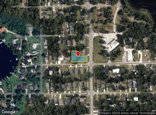
645 S 419Th, Chuluota, FL 32766

NEARBY LISTINGS FOR SALE OR LEASE
Property Detail
645 S 419Th
Orlando-Kissimmee-Sanford, FL
North Chuluota
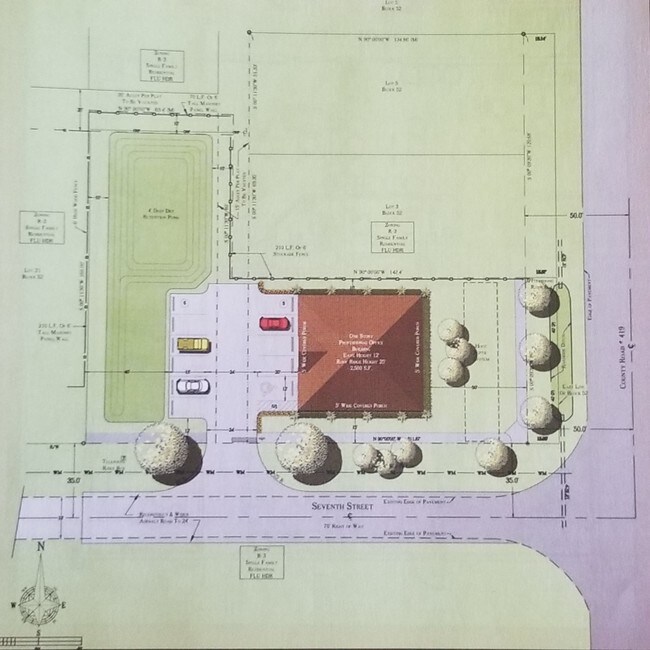
21-21-32-5CF-5200-0010
LOTS 1 & 2 & E 1/2 OF VACD R/W ADJ ON W (LESS E 15 FT FOR RD) & LOT 22 & W 1/2 OF VACD R/W ADJ ON E BLK 52 NORTH CHULUOTA PB 2 PGS 54 TO 58
Commercialacreage
Seminole
X
Florida
12117C0195F
1 2
2024
0.49 AC
2024
E Seminole Outlying
021206
Orlando
DEMOGRAPHICS near 645 S 419Th
1 Mile
3 Mile
5 Mile
2024 Total Population
4,699
19,410
72,850
2029 Population
4,825
20,007
75,036
Pop Growth 2024-2029
+ 2.68%
+ 3.08%
+ 3.00%
Average Age
38
39
37
2024 Total Households
1,507
6,179
23,099
HH Growth 2024-2029
+ 2.79%
+ 3.19%
+ 3.27%
Median Household Inc
$120,384
$122,922
$97,281
Avg Household Size
3.10
3.10
2.90
2024 Avg HH Vehicles
2.00
2.00
2.00
Median Home Value
$448,224
$439,805
$370,041
Median Year Built
2001
1999
1996
Nearby Places
Map Layers
Map Styles
 Street
 Aerial
- Restaurants
- Banks
- Shops
- Fitness
- Groceries
PUBLIC TRANSPORTATION
AIRPORT
Orlando Sanford International
DRIVE
WALK
Distance
Orlando Sanford International
28 min
16.4 mi
Orlando International
DRIVE
WALK
Distance
Orlando International
40 min
25.8 mi
Freight Ports
Port Canaveral
DRIVE
WALK
Distance
Port Canaveral
56 min
41.6 mi
SALE & LEASE HISTORY
LISTING DATE
SALE/LEASE

Dec 01, 2020
For Sale
Apr 10, 2019
For Sale
Nearby Properties
Address
Land Use
TOTAL SIZE
Lot Size
Zoning
Address
Land Use
TOTAL SIZE
Lot Size
Zoning
50,203 SF
5.25 AC
PUD
Address
Land Use
TOTAL SIZE
Lot Size
Zoning
60 SF
6.57 AC
Address
Land Use
TOTAL SIZE
Lot Size
Zoning
5,992 SF
193.76 AC
A1
Address
Land Use
TOTAL SIZE
Lot Size
Zoning
130,481 SF
181.40 AC
PUD
Address
Land Use
TOTAL SIZE
Lot Size
Zoning
17,605 SF
3.27 AC
PUD
Address
Land Use
TOTAL SIZE
Lot Size
Zoning
20,036 SF
1.77 AC
PUD
Address
Land Use
TOTAL SIZE
Lot Size
Zoning
79.28 AC
A5
Address
Land Use
TOTAL SIZE
Lot Size
Zoning
13,710 SF
308.80 AC
PUD
Address
Land Use
TOTAL SIZE
Lot Size
Zoning
11,423 SF
1.52 AC
OC
Address
Land Use
TOTAL SIZE
Lot Size
Zoning
12,455 SF
7.63 AC
PLI
Address
Land Use
TOTAL SIZE
Lot Size
Zoning
10,875 SF
1.56 AC
PUD
Address
Land Use
TOTAL SIZE
Lot Size
Zoning
10,364 SF
24.14 AC
PUD
Address
Land Use
TOTAL SIZE
Lot Size
Zoning
12,099 SF
1.46 AC
PUD
Address
Land Use
TOTAL SIZE
Lot Size
Zoning
10,166 SF
9.09 AC
A5
Address
Land Use
TOTAL SIZE
Lot Size
Zoning
7,755 SF
5.10 AC
PCD
Address
Land Use
TOTAL SIZE
Lot Size
Zoning
1,860 SF
0.84 AC
Address
Land Use
TOTAL SIZE
Lot Size
Zoning
11,204 SF
7.13 AC
A1
Address
Land Use
TOTAL SIZE
Lot Size
Zoning
1 SF
5.16 AC
A1
Address
Land Use
TOTAL SIZE
Lot Size
Zoning
8,820 SF
1.02 AC
PUD
Address
Land Use
TOTAL SIZE
Lot Size
Zoning
13,884 SF
2.60 AC
PUD
Address
Land Use
TOTAL SIZE
Lot Size
Zoning
4,366 SF
27.11 AC
A5
Address
Land Use
TOTAL SIZE
Lot Size
Zoning
4,531 SF
1.35 AC
PUD
Address
Land Use
TOTAL SIZE
Lot Size
Zoning
8,689 SF
6.44 AC
A5
Address
Land Use
TOTAL SIZE
Lot Size
Zoning
1,575 SF
38.39 AC
R1
Address
Land Use
TOTAL SIZE
Lot Size
Zoning
2.38 AC
OC
Address
Land Use
TOTAL SIZE
Lot Size
Zoning
243.35 AC
A5
Address
Land Use
TOTAL SIZE
Lot Size
Zoning
123,578 SF
15.35 AC
PUD
Address
Land Use
TOTAL SIZE
Lot Size
Zoning
4,092 SF
0.78 AC
Address
Land Use
TOTAL SIZE
Lot Size
Zoning
15,310 SF
5 AC
A5
Address
Land Use
TOTAL SIZE
Lot Size
Zoning
199,560 SF
24.95 AC
PUD
The World's #1 Commercial Real Estate Marketplace
Connect with us
© 2025 CoStar Group
The information above has been obtained from sources believed reliable. While we do not doubt its accuracy we have not verified it and make no guarantee, warranty or representation about it. It is your responsibility to independently confirm its accuracy and completeness. Any projections, opinions, assumptions, or estimates used are for example only and do not represent the current or future performance of the property. The value of this transaction to you depends on tax and other factors which should be evaluated by your tax, financial, and legal advisors. You and your advisors should conduct a careful, independent investigation of the property to determine to your satisfaction the suitability of the property for your needs.