Property Record
645 S Powell Rd, Independence, MO 64056


Save to a Folder
{{folder.Name}}
{{folder.ListingIds.length}} Properties
{{folder.ListingIds.length}} Property
Create a New Folder
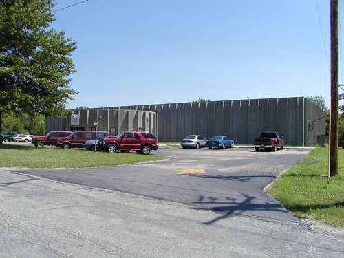
Property Detail
645 S Powell Rd
24-300-02-07-02-0-00-000
SEC 3 TWP 49 RNG 31 TH PT OF NW 1/4 OF TH NW 1/4 DAF: BEG 23 4.89 S OF NW COR OF TH NW 1/4 OF TH NW 1/4 THE 378.48 TH S 250 TH W 378.48 TH N 250 TO POB (EX PT IN ROW)
Warehouse
Jackson
B and X Area of moderate flood hazard, usually the area between the limits of the 100-year and 500-year floods.
Missouri
2024
2.17 AC
2025
Independence
017700
Kansas City
17,330 SF
Kansas City, MO-KS
NEARBY LISTINGS FOR SALE OR LEASE
DEMOGRAPHICS near 645 S Powell Rd
1 mile
3 mile
5 mile
2025 Total Population
1,863
27,817
81,616
2030 Population
1,908
27,835
81,916
Pop Growth 2025-2030
+ 2.42%
+ 0.06%
+ 0.37%
Average Age
39
40
41
2025 Total Households
688
10,435
32,539
HH Growth 2025-2030
+ 2.33%
+ 0.02%
+ 0.38%
Median Household Inc
$90,709
$74,580
$68,553
Avg Household Size
2.70
2.60
2.40
2025 Avg HH Vehicles
2.00
2.00
2.00
Median Home Value
$265,428
$218,681
$212,355
Median Year Built
2002
1977
1976
Nearby Places
Map Layers
Map Styles
 Street
 Aerial
Layers
 Traffic
 Biking
Places
Listings with unknown addresses are not visible on the map
- Restaurants
- Banks
- Shops
- Fitness
- Groceries
PUBLIC TRANSPORTATION
COMMUTER RAIL
Independence Amtrak Station (Lincoln Service Missouri River Runner - Amtrak, Missouri River Runner - Amtrak)
Drive
Walk
Distance
Independence Amtrak Station (Lincoln Service Missouri River Runner - Amtrak, Missouri River Runner - Amtrak)
15 min
6.4 mi
AIRPORT
Kansas City International
Drive
Walk
Distance
Kansas City International
50 min
33.5 mi
Freight Ports
Tulsa Port Of Catoosa
Drive
Walk
Distance
Tulsa Port Of Catoosa
285 min
252.6 mi
Nearby Properties
Address
Land Use
TOTAL SIZE
Lot Size
Zoning
Address
Land Use
TOTAL SIZE
Lot Size
Zoning
250,196 SF
39.50 AC
Address
Land Use
TOTAL SIZE
Lot Size
Zoning
Address
Land Use
TOTAL SIZE
Lot Size
Zoning
287,132 SF
Address
Land Use
TOTAL SIZE
Lot Size
Zoning
193,191 SF
4.14 AC
Address
Land Use
TOTAL SIZE
Lot Size
Zoning
286,547 SF
Address
Land Use
TOTAL SIZE
Lot Size
Zoning
60,949 SF
16.90 AC
Address
Land Use
TOTAL SIZE
Lot Size
Zoning
157,429 SF
36.60 AC
Address
Land Use
TOTAL SIZE
Lot Size
Zoning
56,664 SF
Address
Land Use
TOTAL SIZE
Lot Size
Zoning
24,225 SF
Address
Land Use
TOTAL SIZE
Lot Size
Zoning
45,870 SF
2.01 AC
Address
Land Use
TOTAL SIZE
Lot Size
Zoning
158,109 SF
2.77 AC
Address
Land Use
TOTAL SIZE
Lot Size
Zoning
48,330 SF
12.31 AC
Address
Land Use
TOTAL SIZE
Lot Size
Zoning
246,652 SF
5.07 AC
Address
Land Use
TOTAL SIZE
Lot Size
Zoning
46,489 SF
2.07 AC
Address
Land Use
TOTAL SIZE
Lot Size
Zoning
152,806 SF
94.25 AC
Address
Land Use
TOTAL SIZE
Lot Size
Zoning
47,978 SF
10.20 AC
Address
Land Use
TOTAL SIZE
Lot Size
Zoning
62,070 SF
5.35 AC
Address
Land Use
TOTAL SIZE
Lot Size
Zoning
65,349 SF
15.77 AC
Address
Land Use
TOTAL SIZE
Lot Size
Zoning
60,046 SF
31.82 AC
Address
Land Use
TOTAL SIZE
Lot Size
Zoning
15,015 SF
1.96 AC
Address
Land Use
TOTAL SIZE
Lot Size
Zoning
Address
Land Use
TOTAL SIZE
Lot Size
Zoning
111,555 SF
5.54 AC
Address
Land Use
TOTAL SIZE
Lot Size
Zoning
59,939 SF
9.10 AC
Address
Land Use
TOTAL SIZE
Lot Size
Zoning
45,727 SF
9.50 AC
Address
Land Use
TOTAL SIZE
Lot Size
Zoning
38,765 SF
7 AC
Address
Land Use
TOTAL SIZE
Lot Size
Zoning
118.35 AC
Address
Land Use
TOTAL SIZE
Lot Size
Zoning
60,505 SF
128.04 AC
Address
Land Use
TOTAL SIZE
Lot Size
Zoning
5,832 SF
2.37 AC
Address
Land Use
TOTAL SIZE
Lot Size
Zoning
61,770 SF
19.98 AC
Address
Land Use
TOTAL SIZE
Lot Size
Zoning
50,847 SF
3.71 AC
The World's #1 Commercial Real Estate Marketplace
Connect with us
© 2026 CoStar Group
The information above has been obtained from sources believed reliable. While we do not doubt its accuracy we have not verified it and make no guarantee, warranty or representation about it. It is your responsibility to independently confirm its accuracy and completeness. Any projections, opinions, assumptions, or estimates used are for example only and do not represent the current or future performance of the property. The value of this transaction to you depends on tax and other factors which should be evaluated by your tax, financial, and legal advisors. You and your advisors should conduct a careful, independent investigation of the property to determine to your satisfaction the suitability of the property for your needs.