Property Record
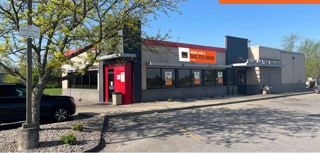
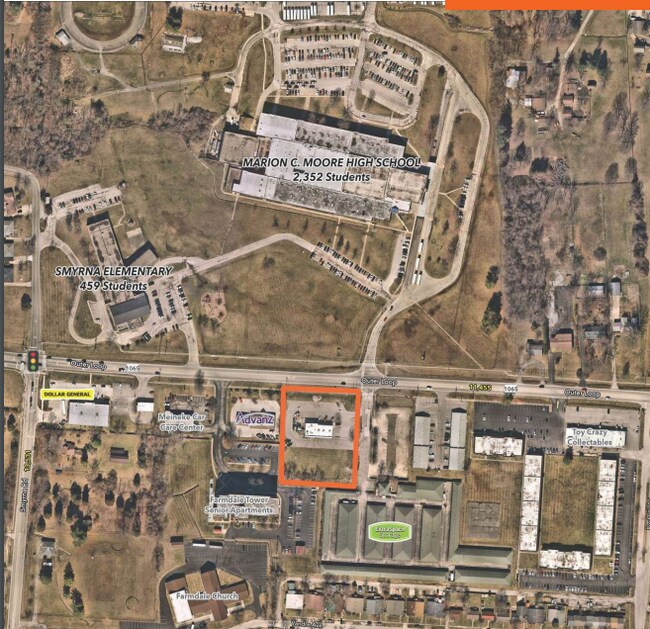
6450 Outer Loop, Louisville, KY 40228

Property Detail
6450 Outer Loop
064503440000
1.771 AC+/-, S SIDE OUTER LOOP, BET SMYRNA & ROCHELLE RD, 248 X 300
Restaurantbuilding
Jefferson
C1-COMMERC
Kentucky
B and X Area of moderate flood hazard, usually the area between the limits of the 100-year and 500-year floods.
1.77 AC
2025
South Central
2025
Louisville
011513
Louisville/Jefferson County, KY-IN
3,750 SF
NEARBY LISTINGS FOR SALE OR LEASE
DEMOGRAPHICS near 6450 Outer Loop
1 mile
3 mile
5 mile
2025 Total Population
11,062
81,121
193,983
2030 Population
11,332
82,734
198,050
Pop Growth 2025-2030
+ 2.44%
+ 1.99%
+ 2.10%
Average Age
42
40
40
2025 Total Households
4,435
32,336
77,537
HH Growth 2025-2030
+ 2.62%
+ 2.05%
+ 2.14%
Median Household Inc
$71,234
$69,232
$66,839
Avg Household Size
2.50
2.50
2.40
2025 Avg HH Vehicles
2.00
2.00
2.00
Median Home Value
$242,591
$228,023
$236,005
Median Year Built
1972
1976
1977
Nearby Places
Map Layers
Map Styles
 Street
 Aerial
Transit
 Traffic
 Biking
Places
Listings with unknown addresses are not visible on the map
- Restaurants
- Banks
- Shops
- Fitness
- Groceries
PUBLIC TRANSPORTATION
AIRPORT
Louisville Muhammad Ali International
Drive
Walk
Distance
Louisville Muhammad Ali International
17 min
8.4 mi
SALE & LEASE HISTORY
LISTING DATE
SALE/LEASE

May 07, 2024
For Lease
Nearby Properties
Address
Land Use
TOTAL SIZE
Lot Size
Zoning
Address
Land Use
TOTAL SIZE
Lot Size
Zoning
22,076 SF
9.49 AC
R6-RESIDEN
Address
Land Use
TOTAL SIZE
Lot Size
Zoning
127,824 SF
53.76 AC
M2-INDUSTR
Address
Land Use
TOTAL SIZE
Lot Size
Zoning
19.16 AC
Address
Land Use
TOTAL SIZE
Lot Size
Zoning
32.44 AC
Address
Land Use
TOTAL SIZE
Lot Size
Zoning
14,166 SF
16.32 AC
C1-COMMERC
Address
Land Use
TOTAL SIZE
Lot Size
Zoning
407,840 SF
25.51 AC
C2-COMMERC
Address
Land Use
TOTAL SIZE
Lot Size
Zoning
4,745 SF
17.95 AC
Address
Land Use
TOTAL SIZE
Lot Size
Zoning
11.17 AC
R6-RESIDEN
Address
Land Use
TOTAL SIZE
Lot Size
Zoning
10.22 AC
C1-COMMERC
Address
Land Use
TOTAL SIZE
Lot Size
Zoning
5,200 SF
7.55 AC
R7-RESIDEN
Address
Land Use
TOTAL SIZE
Lot Size
Zoning
1,450 SF
87.64 AC
M2-INDUSTR
Address
Land Use
TOTAL SIZE
Lot Size
Zoning
7,042 SF
30.40 AC
R5A-RESIDE
Address
Land Use
TOTAL SIZE
Lot Size
Zoning
401,443 SF
28.92 AC
M2-INDUSTR
Address
Land Use
TOTAL SIZE
Lot Size
Zoning
9.44 AC
R5-RESIDEN
Address
Land Use
TOTAL SIZE
Lot Size
Zoning
27.92 AC
EZ1-ENTERP
Address
Land Use
TOTAL SIZE
Lot Size
Zoning
13.68 AC
Address
Land Use
TOTAL SIZE
Lot Size
Zoning
15.24 AC
Address
Land Use
TOTAL SIZE
Lot Size
Zoning
370,297 SF
28.31 AC
M2-INDUSTR
Address
Land Use
TOTAL SIZE
Lot Size
Zoning
Address
Land Use
TOTAL SIZE
Lot Size
Zoning
17.17 AC
EZ1-ENTERP
Address
Land Use
TOTAL SIZE
Lot Size
Zoning
3,654 SF
11.13 AC
R5A-RESIDE
Address
Land Use
TOTAL SIZE
Lot Size
Zoning
24,290 SF
14.88 AC
C2-COMMERC
Address
Land Use
TOTAL SIZE
Lot Size
Zoning
18.67 AC
Address
Land Use
TOTAL SIZE
Lot Size
Zoning
220,847 SF
25.37 AC
C2-COMMERC
Address
Land Use
TOTAL SIZE
Lot Size
Zoning
33,820 SF
11.87 AC
R6-RESIDEN
Address
Land Use
TOTAL SIZE
Lot Size
Zoning
16,372 SF
9.75 AC
CN-NEIGHBO
Address
Land Use
TOTAL SIZE
Lot Size
Zoning
4,000 SF
15.46 AC
C2-COMMERC
Address
Land Use
TOTAL SIZE
Lot Size
Zoning
14.13 AC
R4-RESIDEN
Address
Land Use
TOTAL SIZE
Lot Size
Zoning
15.08 AC
C1-COMMERC
Address
Land Use
TOTAL SIZE
Lot Size
Zoning
14,492 SF
9.07 AC
R7-RESIDEN
The World's #1 Commercial Real Estate Marketplace
Connect with us
© 2026 CoStar Group
The information above has been obtained from sources believed reliable. While we do not doubt its accuracy we have not verified it and make no guarantee, warranty or representation about it. It is your responsibility to independently confirm its accuracy and completeness. Any projections, opinions, assumptions, or estimates used are for example only and do not represent the current or future performance of the property. The value of this transaction to you depends on tax and other factors which should be evaluated by your tax, financial, and legal advisors. You and your advisors should conduct a careful, independent investigation of the property to determine to your satisfaction the suitability of the property for your needs.