Property Record
6451 Rupley Cir, Houston, TX 77087
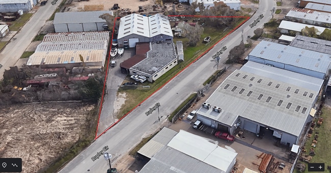
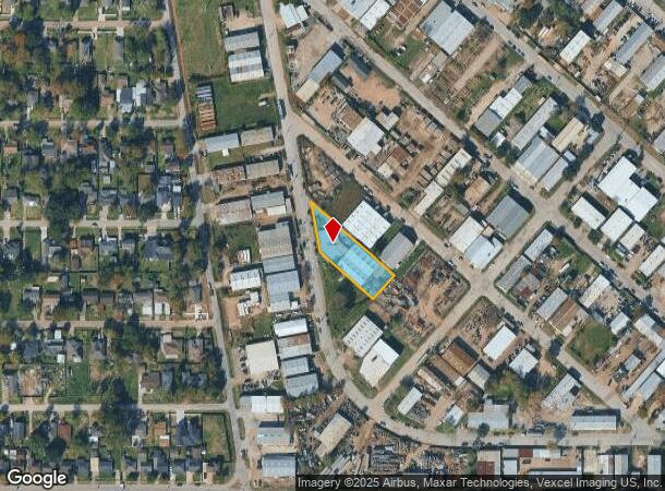
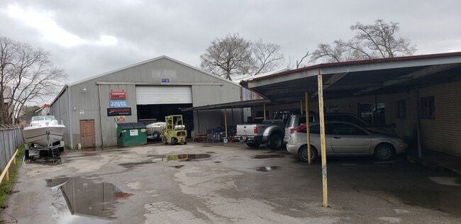
This Property Is For Sale
NEARBY LISTINGS FOR SALE OR LEASE
Property Detail
6451 Rupley Cir
Houston-The Woodlands-Sugar Land, TX
Mayfair Addition
0581290000022
LT 22 BLK 9 MAYFAIR - H B PRENTISS
Warehouse
Harris
X
Texas
48201C0890M
22
2024
0.62 AC
2025
South Hwy 35
332700
Houston
12,586 SF
DEMOGRAPHICS near 6451 Rupley Cir
1 Mile
3 Mile
5 Mile
2024 Total Population
12,446
141,402
335,268
2029 Population
12,867
145,346
346,298
Pop Growth 2024-2029
+ 3.38%
+ 2.79%
+ 3.29%
Average Age
36
37
37
2024 Total Households
4,170
48,381
121,836
HH Growth 2024-2029
+ 3.93%
+ 2.85%
+ 3.46%
Median Household Inc
$39,057
$39,333
$43,544
Avg Household Size
2.90
2.80
2.60
2024 Avg HH Vehicles
2.00
2.00
2.00
Median Home Value
$108,721
$140,929
$164,412
Median Year Built
1969
1961
1968
Nearby Places
- Restaurants
- Banks
- Shops
- Fitness
- Groceries
PUBLIC TRANSPORTATION
COMMUTER RAIL
Houston (Sunset Limited - Amtrak)
DRIVE
WALK
Distance
Houston (Sunset Limited - Amtrak)
14 min
8.0 mi
AIRPORT
William P Hobby
DRIVE
WALK
Distance
William P Hobby
15 min
6.0 mi
George Bush Intcntl/Houston
DRIVE
WALK
Distance
George Bush Intcntl/Houston
37 min
27.8 mi
Freight Ports
Port of Houston
DRIVE
WALK
Distance
Port of Houston
14 min
7.3 mi
Nearby Properties
Address
Land Use
TOTAL SIZE
Lot Size
Zoning
Address
Land Use
TOTAL SIZE
Lot Size
Zoning
453,987 SF
4.33 AC
Address
Land Use
TOTAL SIZE
Lot Size
Zoning
403,242 SF
46.18 AC
Address
Land Use
TOTAL SIZE
Lot Size
Zoning
1,171,276 SF
44.19 AC
Address
Land Use
TOTAL SIZE
Lot Size
Zoning
159,235 SF
1.49 AC
Address
Land Use
TOTAL SIZE
Lot Size
Zoning
310,171 SF
2.35 AC
Address
Land Use
TOTAL SIZE
Lot Size
Zoning
389,108 SF
37.39 AC
Address
Land Use
TOTAL SIZE
Lot Size
Zoning
198,023 SF
17.87 AC
Address
Land Use
TOTAL SIZE
Lot Size
Zoning
504,018 SF
37.16 AC
Address
Land Use
TOTAL SIZE
Lot Size
Zoning
419,760 SF
15.27 AC
Address
Land Use
TOTAL SIZE
Lot Size
Zoning
232,915 SF
7.89 AC
Address
Land Use
TOTAL SIZE
Lot Size
Zoning
228,886 SF
1.85 AC
Address
Land Use
TOTAL SIZE
Lot Size
Zoning
267,844 SF
10.98 AC
Address
Land Use
TOTAL SIZE
Lot Size
Zoning
194,296 SF
15.13 AC
Address
Land Use
TOTAL SIZE
Lot Size
Zoning
196,000 SF
29.42 AC
Address
Land Use
TOTAL SIZE
Lot Size
Zoning
210,476 SF
9.60 AC
Address
Land Use
TOTAL SIZE
Lot Size
Zoning
284,290 SF
20 AC
Address
Land Use
TOTAL SIZE
Lot Size
Zoning
113,688 SF
4 AC
Address
Land Use
TOTAL SIZE
Lot Size
Zoning
257,481 SF
9.28 AC
Address
Land Use
TOTAL SIZE
Lot Size
Zoning
244,134 SF
9.44 AC
Address
Land Use
TOTAL SIZE
Lot Size
Zoning
100,458 SF
8.54 AC
Address
Land Use
TOTAL SIZE
Lot Size
Zoning
241,999 SF
8.46 AC
Address
Land Use
TOTAL SIZE
Lot Size
Zoning
54,077 SF
5.06 AC
Address
Land Use
TOTAL SIZE
Lot Size
Zoning
44,327 SF
5.40 AC
Address
Land Use
TOTAL SIZE
Lot Size
Zoning
126,000 SF
1.51 AC
Address
Land Use
TOTAL SIZE
Lot Size
Zoning
445,535 SF
36.94 AC
Address
Land Use
TOTAL SIZE
Lot Size
Zoning
241,219 SF
8.92 AC
Address
Land Use
TOTAL SIZE
Lot Size
Zoning
155,657 SF
3.59 AC
Address
Land Use
TOTAL SIZE
Lot Size
Zoning
177,406 SF
10.86 AC
Address
Land Use
TOTAL SIZE
Lot Size
Zoning
215,004 SF
7.76 AC
Address
Land Use
TOTAL SIZE
Lot Size
Zoning
222,896 SF
10.79 AC
The World's #1 Commercial Real Estate Marketplace
Connect with us
© 2025 CoStar Group
The information above has been obtained from sources believed reliable. While we do not doubt its accuracy we have not verified it and make no guarantee, warranty or representation about it. It is your responsibility to independently confirm its accuracy and completeness. Any projections, opinions, assumptions, or estimates used are for example only and do not represent the current or future performance of the property. The value of this transaction to you depends on tax and other factors which should be evaluated by your tax, financial, and legal advisors. You and your advisors should conduct a careful, independent investigation of the property to determine to your satisfaction the suitability of the property for your needs.