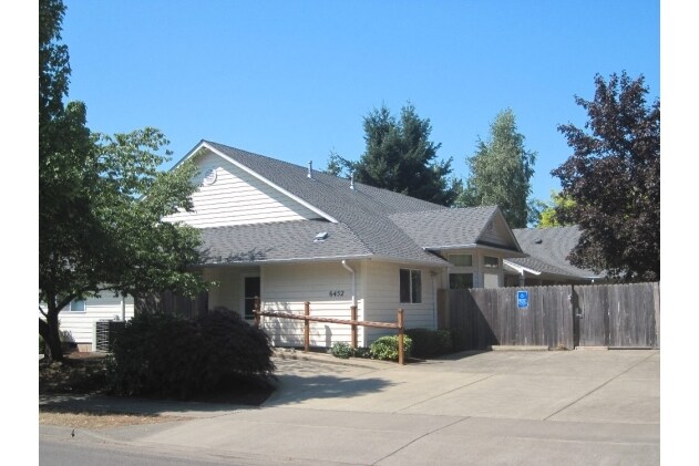
Property Record
6452 A St, Springfield, OR 97478


Property Detail
6452 A St
Eugene-Springfield, OR
TL 04000
1199593
Lane
Commercialnec
Oregon
LD
4000
B and X Area of moderate flood hazard, usually the area between the limits of the 100-year and 500-year floods.
0.22 AC
2025
Lane County
2025
Portland
001803
NEARBY LISTINGS FOR SALE OR LEASE
-
-
View all Springfield listings for sale on LoopNet.com
DEMOGRAPHICS near 6452 A St
1 mile
3 mile
5 mile
2025 Total Population
11,229
28,448
50,526
2030 Population
11,052
28,146
50,054
Pop Growth 2025-2030
(1.58%)
(1.06%)
(0.93%)
Average Age
41
40
41
2025 Total Households
4,152
10,565
19,405
HH Growth 2025-2030
(1.66%)
(1.18%)
(1.02%)
Median Household Inc
$81,267
$78,402
$77,009
Avg Household Size
2.60
2.60
2.50
2025 Avg HH Vehicles
2.00
2.00
2.00
Median Home Value
$404,330
$377,771
$383,444
Median Year Built
1980
1979
1975
Nearby Places
Map Layers
Map Styles
 Street
 Aerial
Layers
 Traffic
 Biking
Places
Listings with unknown addresses are not visible on the map
- Restaurants
- Banks
- Shops
- Fitness
- Groceries
PUBLIC TRANSPORTATION
AIRPORT
Mahlon Sweet Field
Drive
Walk
Distance
Mahlon Sweet Field
29 min
18.5 mi
Freight Ports
Port of Coos Bay, OR
Drive
Walk
Distance
Port of Coos Bay, OR
165 min
118.5 mi
Nearby Properties
Address
Land Use
TOTAL SIZE
Lot Size
Zoning
Address
Land Use
TOTAL SIZE
Lot Size
Zoning
Address
Land Use
TOTAL SIZE
Lot Size
Zoning
179 AC
E30
Address
Land Use
TOTAL SIZE
Lot Size
Zoning
27.44 AC
LD
Address
Land Use
TOTAL SIZE
Lot Size
Zoning
11.12 AC
HI
Address
Land Use
TOTAL SIZE
Lot Size
Zoning
5.39 AC
LD
Address
Land Use
TOTAL SIZE
Lot Size
Zoning
3.58 AC
HD
Address
Land Use
TOTAL SIZE
Lot Size
Zoning
13.84 AC
HD
Address
Land Use
TOTAL SIZE
Lot Size
Zoning
9.23 AC
LD
Address
Land Use
TOTAL SIZE
Lot Size
Zoning
18.70 AC
E30
Address
Land Use
TOTAL SIZE
Lot Size
Zoning
7.78 AC
LD
Address
Land Use
TOTAL SIZE
Lot Size
Zoning
5.88 AC
LD
Address
Land Use
TOTAL SIZE
Lot Size
Zoning
119.04 AC
E30
Address
Land Use
TOTAL SIZE
Lot Size
Zoning
4.47 AC
CC
Address
Land Use
TOTAL SIZE
Lot Size
Zoning
8.06 AC
HD
Address
Land Use
TOTAL SIZE
Lot Size
Zoning
7.79 AC
E30
Address
Land Use
TOTAL SIZE
Lot Size
Zoning
9.93 AC
LD
Address
Land Use
TOTAL SIZE
Lot Size
Zoning
32.97 AC
E30
Address
Land Use
TOTAL SIZE
Lot Size
Zoning
3.49 AC
HI
Address
Land Use
TOTAL SIZE
Lot Size
Zoning
46.87 AC
E30
Address
Land Use
TOTAL SIZE
Lot Size
Zoning
2.20 AC
HD
Address
Land Use
TOTAL SIZE
Lot Size
Zoning
5.63 AC
LD
Address
Land Use
TOTAL SIZE
Lot Size
Zoning
3.28 AC
CC
Address
Land Use
TOTAL SIZE
Lot Size
Zoning
1,312 SF
4.93 AC
CC
Address
Land Use
TOTAL SIZE
Lot Size
Zoning
4.68 AC
CC
Address
Land Use
TOTAL SIZE
Lot Size
Zoning
132.96 AC
E30
Address
Land Use
TOTAL SIZE
Lot Size
Zoning
3.59 AC
CC
Address
Land Use
TOTAL SIZE
Lot Size
Zoning
3.36 AC
CC
Address
Land Use
TOTAL SIZE
Lot Size
Zoning
11.28 AC
LD
Address
Land Use
TOTAL SIZE
Lot Size
Zoning
3.28 AC
CC
Address
Land Use
TOTAL SIZE
Lot Size
Zoning
0.72 AC
CC
The World's #1 Commercial Real Estate Marketplace
Connect with us
© 2026 CoStar Group
The information above has been obtained from sources believed reliable. While we do not doubt its accuracy we have not verified it and make no guarantee, warranty or representation about it. It is your responsibility to independently confirm its accuracy and completeness. Any projections, opinions, assumptions, or estimates used are for example only and do not represent the current or future performance of the property. The value of this transaction to you depends on tax and other factors which should be evaluated by your tax, financial, and legal advisors. You and your advisors should conduct a careful, independent investigation of the property to determine to your satisfaction the suitability of the property for your needs.