Property Record
6455 E 106Th St N, Sperry, OK 74073

This Property Is For Sale
Property Detail
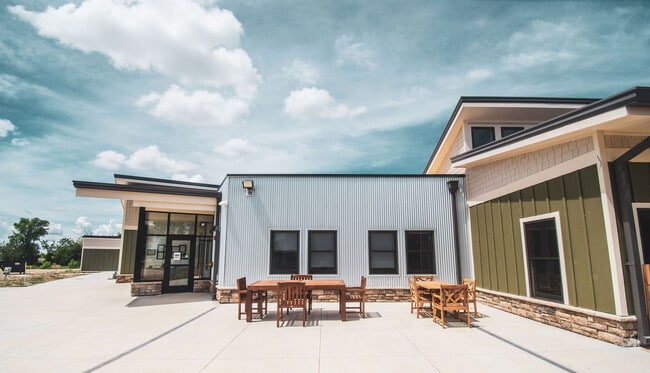
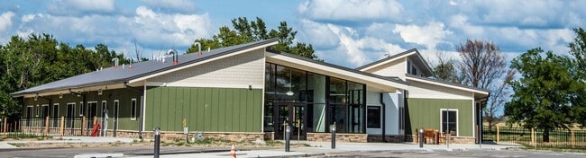
6455 E 106Th St N
91310-13-10-58010
SE SE SE LESS E50 & S50 SEC 10 21 13 8.542 ACS
Daycare
Tulsa
AG
Oklahoma
B and X Area of moderate flood hazard, usually the area between the limits of the 100-year and 500-year floods.
8.54 AC
2025
Northeast
2025
Tulsa
005808
Tulsa, OK
13,270 SF
NEARBY LISTINGS FOR SALE OR LEASE
-
-
View all Sperry listings for sale on LoopNet.com
DEMOGRAPHICS near 6455 E 106Th St N
1 mile
3 mile
5 mile
2025 Total Population
173
13,090
44,186
2030 Population
186
13,655
45,719
Pop Growth 2025-2030
+ 7.51%
+ 4.32%
+ 3.47%
Average Age
42
39
38
2025 Total Households
61
4,850
16,380
HH Growth 2025-2030
+ 8.20%
+ 4.27%
+ 3.49%
Median Household Inc
$128,846
$101,142
$85,313
Avg Household Size
2.70
2.70
2.70
2025 Avg HH Vehicles
3.00
2.00
2.00
Median Home Value
$519,231
$312,826
$265,645
Median Year Built
2010
2004
1998
Nearby Places
Map Layers
Map Styles
 Street
 Aerial
Layers
 Traffic
 Biking
Places
Listings with unknown addresses are not visible on the map
- Restaurants
- Banks
- Shops
- Fitness
- Groceries
PUBLIC TRANSPORTATION
AIRPORT
Tulsa International
Drive
Walk
Distance
Tulsa International
18 min
10.9 mi
Freight Ports
Tulsa Port Of Catoosa
Drive
Walk
Distance
Tulsa Port Of Catoosa
23 min
15.5 mi
Nearby Properties
Address
Land Use
TOTAL SIZE
Lot Size
Zoning
Address
Land Use
TOTAL SIZE
Lot Size
Zoning
65,354 SF
41.54 AC
AG
Address
Land Use
TOTAL SIZE
Lot Size
Zoning
115,952 SF
19.30 AC
RS3
Address
Land Use
TOTAL SIZE
Lot Size
Zoning
457,823 SF
25.72 AC
IM
Address
Land Use
TOTAL SIZE
Lot Size
Zoning
266,778 SF
12.26 AC
CN
Address
Land Use
TOTAL SIZE
Lot Size
Zoning
27,314 SF
12.29 AC
AG
Address
Land Use
TOTAL SIZE
Lot Size
Zoning
133,467 SF
11.37 AC
CS
Address
Land Use
TOTAL SIZE
Lot Size
Zoning
101,776 SF
9.96 AC
CS
Address
Land Use
TOTAL SIZE
Lot Size
Zoning
133,301 SF
21.09 AC
RS3
Address
Land Use
TOTAL SIZE
Lot Size
Zoning
61.50 AC
Address
Land Use
TOTAL SIZE
Lot Size
Zoning
140,358 SF
5.10 AC
RM1
Address
Land Use
TOTAL SIZE
Lot Size
Zoning
3,679 SF
33.74 AC
AG
Address
Land Use
TOTAL SIZE
Lot Size
Zoning
8,334 SF
46.11 AC
AG
Address
Land Use
TOTAL SIZE
Lot Size
Zoning
114,618 SF
7.02 AC
RM1
Address
Land Use
TOTAL SIZE
Lot Size
Zoning
113.74 AC
AG
Address
Land Use
TOTAL SIZE
Lot Size
Zoning
97,860 SF
7.16 AC
RS3
Address
Land Use
TOTAL SIZE
Lot Size
Zoning
12,134 SF
26.27 AC
RS3
Address
Land Use
TOTAL SIZE
Lot Size
Zoning
52,842 SF
1.15 AC
RS3
Address
Land Use
TOTAL SIZE
Lot Size
Zoning
14,836 SF
9.39 AC
AGR
Address
Land Use
TOTAL SIZE
Lot Size
Zoning
23,375 SF
3.52 AC
CN
Address
Land Use
TOTAL SIZE
Lot Size
Zoning
312 SF
4.19 AC
AG
Address
Land Use
TOTAL SIZE
Lot Size
Zoning
6,280 SF
15.43 AC
AG
Address
Land Use
TOTAL SIZE
Lot Size
Zoning
58,956 SF
8.70 AC
RE
Address
Land Use
TOTAL SIZE
Lot Size
Zoning
10,812 SF
8.56 AC
AG
Address
Land Use
TOTAL SIZE
Lot Size
Zoning
4,903 SF
2.51 AC
CS
Address
Land Use
TOTAL SIZE
Lot Size
Zoning
3,350 SF
0.86 AC
AGR
Address
Land Use
TOTAL SIZE
Lot Size
Zoning
64,400 SF
7.18 AC
IL
Address
Land Use
TOTAL SIZE
Lot Size
Zoning
15.89 AC
AG
Address
Land Use
TOTAL SIZE
Lot Size
Zoning
22,780 SF
4.62 AC
CS
Address
Land Use
TOTAL SIZE
Lot Size
Zoning
33.59 AC
RS3
The World's #1 Commercial Real Estate Marketplace
Connect with us
© 2026 CoStar Group
The information above has been obtained from sources believed reliable. While we do not doubt its accuracy we have not verified it and make no guarantee, warranty or representation about it. It is your responsibility to independently confirm its accuracy and completeness. Any projections, opinions, assumptions, or estimates used are for example only and do not represent the current or future performance of the property. The value of this transaction to you depends on tax and other factors which should be evaluated by your tax, financial, and legal advisors. You and your advisors should conduct a careful, independent investigation of the property to determine to your satisfaction the suitability of the property for your needs.