Property Record
646 Highway 58 St E, Norton, VA 24273

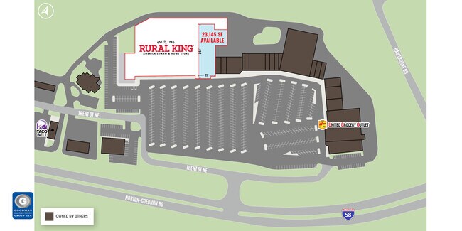
Current Lease Availabilities
Property Detail
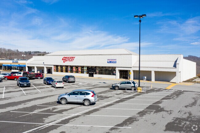
646 Highway 58 St E
Storebuilding
16.910 ACRE WAL MART TAX PLAT
B-3
NORTON CITY
B and X Area of moderate flood hazard, usually the area between the limits of the 100-year and 500-year floods.
Virginia
2026
16.91 AC
2026
Virginia Regional
960100
Other Market Areas
112,732 SF
232N-3507
NEARBY LISTINGS FOR SALE OR LEASE
DEMOGRAPHICS near 646 Highway 58 St E
1 mile
3 mile
5 mile
2025 Total Population
1,336
5,812
11,796
2030 Population
1,271
5,564
11,291
Pop Growth 2025-2030
(4.87%)
(4.27%)
(4.28%)
Average Age
40
42
42
2025 Total Households
573
2,554
4,993
HH Growth 2025-2030
(4.54%)
(4.27%)
(4.45%)
Median Household Inc
$39,867
$46,227
$48,412
Avg Household Size
2.30
2.20
2.30
2025 Avg HH Vehicles
2.00
2.00
2.00
Median Home Value
$107,874
$118,164
$129,285
Median Year Built
1968
1975
1977
Nearby Places
Map Layers
Map Styles
 Street
 Aerial
Layers
 Traffic
 Biking
Places
Listings with unknown addresses are not visible on the map
- Restaurants
- Banks
- Shops
- Fitness
- Groceries
Nearby Properties
Address
Land Use
TOTAL SIZE
Lot Size
Zoning
Address
Land Use
TOTAL SIZE
Lot Size
Zoning
114.36 AC
M-1
Address
Land Use
TOTAL SIZE
Lot Size
Zoning
204,938 SF
25.65 AC
B-3
Address
Land Use
TOTAL SIZE
Lot Size
Zoning
89,992 SF
13.05 AC
B-3
Address
Land Use
TOTAL SIZE
Lot Size
Zoning
173,126 SF
8.53 AC
Address
Land Use
TOTAL SIZE
Lot Size
Zoning
7,240 SF
9.13 AC
Address
Land Use
TOTAL SIZE
Lot Size
Zoning
52,691 SF
11.30 AC
Address
Land Use
TOTAL SIZE
Lot Size
Zoning
170,986 SF
21.37 AC
Address
Land Use
TOTAL SIZE
Lot Size
Zoning
69,358 SF
10 AC
R-B
Address
Land Use
TOTAL SIZE
Lot Size
Zoning
92,816 SF
14.25 AC
R-A
Address
Land Use
TOTAL SIZE
Lot Size
Zoning
80,866 SF
21.39 AC
B-3
Address
Land Use
TOTAL SIZE
Lot Size
Zoning
33,849 SF
0.43 AC
Address
Land Use
TOTAL SIZE
Lot Size
Zoning
3,696 SF
687 AC
R-CR
Address
Land Use
TOTAL SIZE
Lot Size
Zoning
101,860 SF
1.77 AC
B-1
Address
Land Use
TOTAL SIZE
Lot Size
Zoning
37,387 SF
0.92 AC
Address
Land Use
TOTAL SIZE
Lot Size
Zoning
47,218 SF
1.70 AC
Address
Land Use
TOTAL SIZE
Lot Size
Zoning
51,984 SF
3.70 AC
B-3
Address
Land Use
TOTAL SIZE
Lot Size
Zoning
45,636 SF
10.81 AC
Address
Land Use
TOTAL SIZE
Lot Size
Zoning
Address
Land Use
TOTAL SIZE
Lot Size
Zoning
11,835 SF
6.14 AC
Address
Land Use
TOTAL SIZE
Lot Size
Zoning
10,000 SF
3.80 AC
B-3
Address
Land Use
TOTAL SIZE
Lot Size
Zoning
75,550 SF
0.52 AC
B-2
Address
Land Use
TOTAL SIZE
Lot Size
Zoning
47,766 SF
12.24 AC
R-B
Address
Land Use
TOTAL SIZE
Lot Size
Zoning
28,057 SF
2.97 AC
Address
Land Use
TOTAL SIZE
Lot Size
Zoning
48,924 SF
5 AC
Address
Land Use
TOTAL SIZE
Lot Size
Zoning
40,240 SF
3.45 AC
B-3
Address
Land Use
TOTAL SIZE
Lot Size
Zoning
28,240 SF
0.38 AC
Address
Land Use
TOTAL SIZE
Lot Size
Zoning
20,032 SF
3.96 AC
B-3
Address
Land Use
TOTAL SIZE
Lot Size
Zoning
4.41 AC
Address
Land Use
TOTAL SIZE
Lot Size
Zoning
116,004 SF
11.66 AC
B-3
The World's #1 Commercial Real Estate Marketplace
Connect with us
© 2026 CoStar Group
The information above has been obtained from sources believed reliable. While we do not doubt its accuracy we have not verified it and make no guarantee, warranty or representation about it. It is your responsibility to independently confirm its accuracy and completeness. Any projections, opinions, assumptions, or estimates used are for example only and do not represent the current or future performance of the property. The value of this transaction to you depends on tax and other factors which should be evaluated by your tax, financial, and legal advisors. You and your advisors should conduct a careful, independent investigation of the property to determine to your satisfaction the suitability of the property for your needs.