Property Record
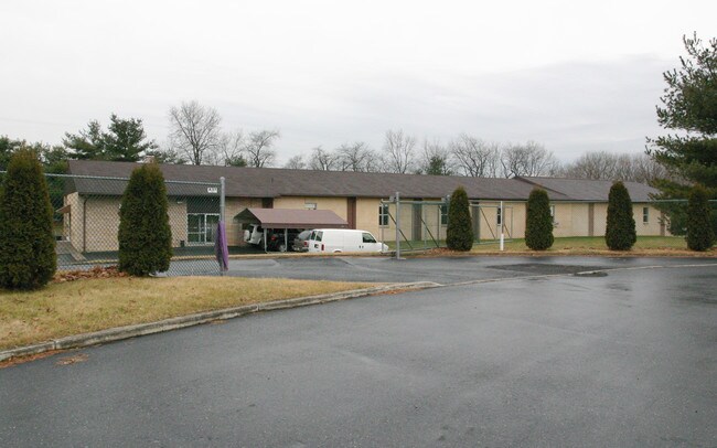
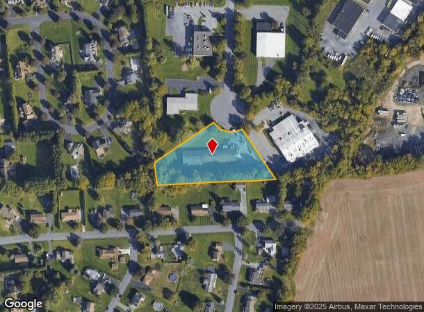
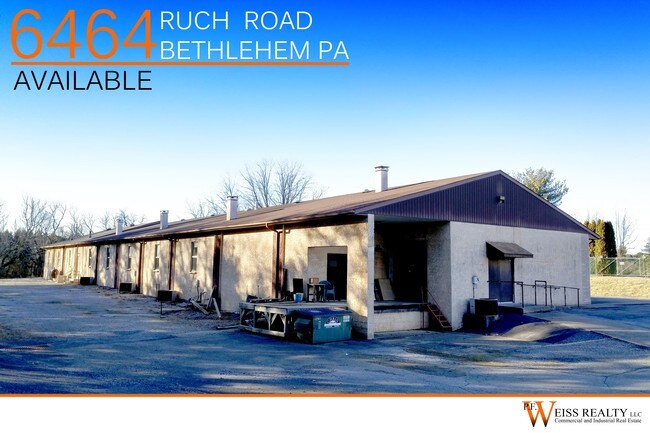
6464 Ruch Rd, Bethlehem, PA 18017
NEARBY LISTINGS FOR SALE OR LEASE
-
-
-
No Photo
-
-
-
-
-
View all Bethlehem listings for sale on LoopNet.com
Property Detail
6464 Ruch Rd
Industrialpark
Northampton
X
Pennsylvania
42095C0241E
2.01 AC
2025
Lehigh Valley
2025
Philadelphia
016500
Allentown-Bethlehem-Easton, PA-NJ
11,804 SF
M5-4-3G-0508
DEMOGRAPHICS near 6464 Ruch Rd
1 Mile
3 Mile
5 Mile
2024 Total Population
2,642
30,951
147,661
2029 Population
2,668
31,250
148,486
Pop Growth 2024-2029
+ 0.98%
+ 0.97%
+ 0.56%
Average Age
44
45
42
2024 Total Households
957
12,792
59,729
HH Growth 2024-2029
+ 1.04%
+ 1.09%
+ 0.53%
Median Household Inc
$100,591
$81,472
$69,799
Avg Household Size
2.70
2.40
2.40
2024 Avg HH Vehicles
2.00
2.00
2.00
Median Home Value
$338,953
$278,970
$233,182
Median Year Built
1985
1977
1964
Nearby Places
Map Layers
Map Styles
 Street
 Aerial
- Restaurants
- Banks
- Shops
- Fitness
- Groceries
PUBLIC TRANSPORTATION
AIRPORT
Lehigh Valley International
DRIVE
WALK
Distance
Lehigh Valley International
9 min
3.8 mi
Freight Ports
Port of Philadelphia
DRIVE
WALK
Distance
Port of Philadelphia
94 min
69.7 mi
SALE & LEASE HISTORY
LISTING DATE
SALE/LEASE

Sep 24, 2016
For Sale
Nov 10, 2017
For Sale
Nov 10, 2017
For Lease
Nearby Properties
Address
Land Use
TOTAL SIZE
Lot Size
Zoning
Address
Land Use
TOTAL SIZE
Lot Size
Zoning
93,719 SF
789.61 AC
AI
Address
Land Use
TOTAL SIZE
Lot Size
Zoning
649,498 SF
22.51 AC
I
Address
Land Use
TOTAL SIZE
Lot Size
Zoning
298,543 SF
55.08 AC
PIO
Address
Land Use
TOTAL SIZE
Lot Size
Zoning
453,600 SF
32.57 AC
PIO
Address
Land Use
TOTAL SIZE
Lot Size
Zoning
1,046,625 SF
69.55 AC
RS
Address
Land Use
TOTAL SIZE
Lot Size
Zoning
956,444 SF
I
Address
Land Use
TOTAL SIZE
Lot Size
Zoning
13,164 SF
27.89 AC
RT
Address
Land Use
TOTAL SIZE
Lot Size
Zoning
1,050,392 SF
218.15 AC
RS
Address
Land Use
TOTAL SIZE
Lot Size
Zoning
605,906 SF
94.28 AC
A
Address
Land Use
TOTAL SIZE
Lot Size
Zoning
509,445 SF
43.15 AC
PIO
Address
Land Use
TOTAL SIZE
Lot Size
Zoning
605,893 SF
I
Address
Land Use
TOTAL SIZE
Lot Size
Zoning
104,379 SF
21.57 AC
CS
Address
Land Use
TOTAL SIZE
Lot Size
Zoning
164,451 SF
15.06 AC
PI
Address
Land Use
TOTAL SIZE
Lot Size
Zoning
276,484 SF
31.19 AC
A
Address
Land Use
TOTAL SIZE
Lot Size
Zoning
95,776 SF
23.70 AC
INS
Address
Land Use
TOTAL SIZE
Lot Size
Zoning
452,012 SF
40.39 AC
PC
Address
Land Use
TOTAL SIZE
Lot Size
Zoning
96,999 SF
19.37 AC
INS
Address
Land Use
TOTAL SIZE
Lot Size
Zoning
11,356 SF
16.26 AC
RG
Address
Land Use
TOTAL SIZE
Lot Size
Zoning
197,120 SF
14.06 AC
PIO
Address
Land Use
TOTAL SIZE
Lot Size
Zoning
84,438 SF
7.81 AC
AI
Address
Land Use
TOTAL SIZE
Lot Size
Zoning
57,635 SF
2.69 AC
I
Address
Land Use
TOTAL SIZE
Lot Size
Zoning
298,660 SF
37.43 AC
PIBD
Address
Land Use
TOTAL SIZE
Lot Size
Zoning
105,219 SF
47.10 AC
RA
Address
Land Use
TOTAL SIZE
Lot Size
Zoning
533,165 SF
54.66 AC
LI/BP
Address
Land Use
TOTAL SIZE
Lot Size
Zoning
92,428 SF
3.88 AC
CS
Address
Land Use
TOTAL SIZE
Lot Size
Zoning
6,325 SF
4.96 AC
CS
Address
Land Use
TOTAL SIZE
Lot Size
Zoning
116,719 SF
4.91 AC
PI
Address
Land Use
TOTAL SIZE
Lot Size
Zoning
2,726 SF
13.40 AC
RG
Address
Land Use
TOTAL SIZE
Lot Size
Zoning
292,700 SF
21.68 AC
RS
Address
Land Use
TOTAL SIZE
Lot Size
Zoning
173,706 SF
15.37 AC
PIO
The World's #1 Commercial Real Estate Marketplace
Connect with us
© 2025 CoStar Group
The information above has been obtained from sources believed reliable. While we do not doubt its accuracy we have not verified it and make no guarantee, warranty or representation about it. It is your responsibility to independently confirm its accuracy and completeness. Any projections, opinions, assumptions, or estimates used are for example only and do not represent the current or future performance of the property. The value of this transaction to you depends on tax and other factors which should be evaluated by your tax, financial, and legal advisors. You and your advisors should conduct a careful, independent investigation of the property to determine to your satisfaction the suitability of the property for your needs.