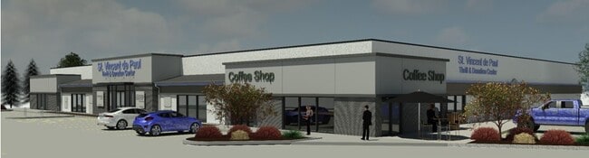
Property Record
6464 W State St, Boise, ID 83714


Current Lease Availabilities
NEARBY LISTINGS FOR SALE OR LEASE
Property Detail
6464 W State St
S0630223115
PAR #6317 POR SW4SW4 SEC 19 4N 2E IN TCA 01-44 S0619336313-R
Commercialacreage
Ada
X
Idaho
16001C0167J
0.58 AC
2024
North Boise
2025
Boise City/Nampa
000305
Boise City, ID
24,640 SF
DEMOGRAPHICS near 6464 W State St
1 Mile
3 Mile
5 Mile
2024 Total Population
11,690
70,743
190,857
2029 Population
13,202
79,786
215,787
Pop Growth 2024-2029
+ 12.93%
+ 12.78%
+ 13.06%
Average Age
44
43
41
2024 Total Households
5,401
29,785
79,317
HH Growth 2024-2029
+ 13.29%
+ 13.07%
+ 13.39%
Median Household Inc
$73,760
$70,213
$70,040
Avg Household Size
2.10
2.30
2.30
2024 Avg HH Vehicles
2.00
2.00
2.00
Median Home Value
$446,106
$427,756
$454,070
Median Year Built
1992
1987
1989
Nearby Places
Map Layers
Map Styles
 Street
 Aerial
- Restaurants
- Banks
- Shops
- Fitness
- Groceries
PUBLIC TRANSPORTATION
AIRPORT
Boise Air Trml/Gowen Field
DRIVE
WALK
Distance
Boise Air Trml/Gowen Field
35 min
13.1 mi
Freight Ports
Port of Portland
DRIVE
WALK
Distance
Port of Portland
478 min
429.0 mi
Nearby Properties
Address
Land Use
TOTAL SIZE
Lot Size
Zoning
Address
Land Use
TOTAL SIZE
Lot Size
Zoning
386,225 SF
13.46 AC
ZC-270
Address
Land Use
TOTAL SIZE
Lot Size
Zoning
4.02 AC
C-2/DA
Address
Land Use
TOTAL SIZE
Lot Size
Zoning
207,033 SF
10.67 AC
ZC-243
Address
Land Use
TOTAL SIZE
Lot Size
Zoning
245,000 SF
12.28 AC
R-2
Address
Land Use
TOTAL SIZE
Lot Size
Zoning
216,950 SF
9.03 AC
R-3
Address
Land Use
TOTAL SIZE
Lot Size
Zoning
151,285 SF
9.54 AC
R-1C
Address
Land Use
TOTAL SIZE
Lot Size
Zoning
222,379 SF
1.37 AC
M
Address
Land Use
TOTAL SIZE
Lot Size
Zoning
150,584 SF
6.77 AC
M
Address
Land Use
TOTAL SIZE
Lot Size
Zoning
7.16 AC
ZC-251
Address
Land Use
TOTAL SIZE
Lot Size
Zoning
203,635 SF
4.76 AC
ZC-245
Address
Land Use
TOTAL SIZE
Lot Size
Zoning
176,494 SF
10.16 AC
R-1C
Address
Land Use
TOTAL SIZE
Lot Size
Zoning
167,603 SF
6.60 AC
C-2DA
Address
Land Use
TOTAL SIZE
Lot Size
Zoning
10.32 AC
ZC-251
Address
Land Use
TOTAL SIZE
Lot Size
Zoning
124,286 SF
5 AC
R-3
Address
Land Use
TOTAL SIZE
Lot Size
Zoning
102,272 SF
7.18 AC
R-20
Address
Land Use
TOTAL SIZE
Lot Size
Zoning
92,243 SF
2.05 AC
R-3
Address
Land Use
TOTAL SIZE
Lot Size
Zoning
204,033 SF
12.88 AC
C-1
Address
Land Use
TOTAL SIZE
Lot Size
Zoning
159,839 SF
16.94 AC
C-2
Address
Land Use
TOTAL SIZE
Lot Size
Zoning
123,324 SF
2.22 AC
R-3
Address
Land Use
TOTAL SIZE
Lot Size
Zoning
84,070 SF
4.22 AC
R-3
Address
Land Use
TOTAL SIZE
Lot Size
Zoning
28,776 SF
3.30 AC
ZC-243
Address
Land Use
TOTAL SIZE
Lot Size
Zoning
80,722 SF
4.59 AC
ZC-243
Address
Land Use
TOTAL SIZE
Lot Size
Zoning
63,476 SF
3.58 AC
R-2
Address
Land Use
TOTAL SIZE
Lot Size
Zoning
111,478 SF
7.41 AC
ZC-243
Address
Land Use
TOTAL SIZE
Lot Size
Zoning
30,144 SF
22.20 AC
R-3
Address
Land Use
TOTAL SIZE
Lot Size
Zoning
102,094 SF
7.15 AC
C-2
Address
Land Use
TOTAL SIZE
Lot Size
Zoning
119,680 SF
11 AC
ZC-245
Address
Land Use
TOTAL SIZE
Lot Size
Zoning
86,398 SF
5.38 AC
ZC-268
Address
Land Use
TOTAL SIZE
Lot Size
Zoning
72,258 SF
4.30 AC
R-3
Address
Land Use
TOTAL SIZE
Lot Size
Zoning
112,281 SF
9.72 AC
C-3
The World's #1 Commercial Real Estate Marketplace
Connect with us
© 2025 CoStar Group
The information above has been obtained from sources believed reliable. While we do not doubt its accuracy we have not verified it and make no guarantee, warranty or representation about it. It is your responsibility to independently confirm its accuracy and completeness. Any projections, opinions, assumptions, or estimates used are for example only and do not represent the current or future performance of the property. The value of this transaction to you depends on tax and other factors which should be evaluated by your tax, financial, and legal advisors. You and your advisors should conduct a careful, independent investigation of the property to determine to your satisfaction the suitability of the property for your needs.