Property Record
6465 Highway 78 S, Nevada, TX 75173
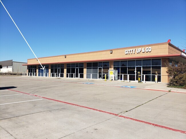


Property Detail
6465 Highway 78 S
Dallas-Fort Worth-Arlington, TX
PINKUS ADDITION, BLK A, LOT 2
R-11725-00A-0020-1
COLLIN
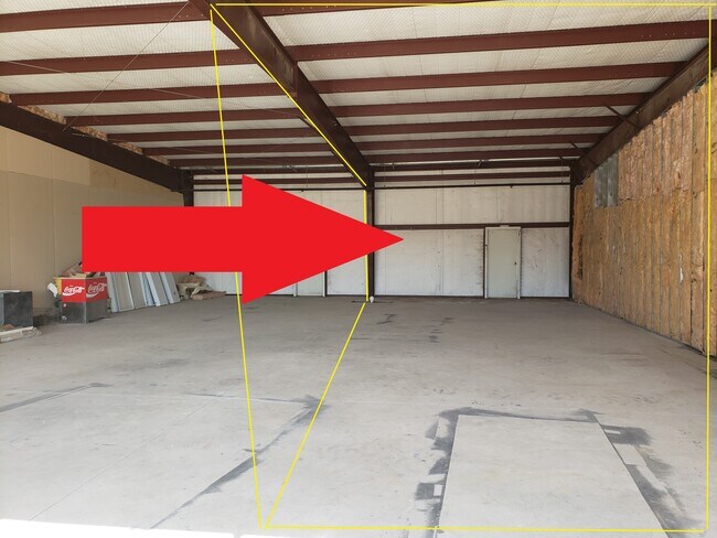
Commercialnec
Texas
B and X Area of moderate flood hazard, usually the area between the limits of the 100-year and 500-year floods.
2
2025
2.58 AC
2025
East Plano
031102
Dallas/Ft Worth
7,680 SF
NEARBY LISTINGS FOR SALE OR LEASE
-
-
View all Nevada listings for lease on LoopNet.com
DEMOGRAPHICS near 6465 Highway 78 S
1 mile
3 mile
5 mile
2025 Total Population
971
10,242
25,607
2030 Population
1,129
12,235
30,599
Pop Growth 2025-2030
+ 16.27%
+ 19.46%
+ 19.49%
Average Age
40
39
39
2025 Total Households
324
3,368
8,554
HH Growth 2025-2030
+ 16.67%
+ 19.54%
+ 19.72%
Median Household Inc
$101,603
$120,034
$106,454
Avg Household Size
2.90
3.00
3.00
2025 Avg HH Vehicles
3.00
3.00
2.00
Median Home Value
$476,153
$458,031
$447,335
Median Year Built
2007
2010
2010
Nearby Places
Map Layers
Map Styles
 Street
 Aerial
Layers
 Traffic
 Biking
Places
Listings with unknown addresses are not visible on the map
- Restaurants
- Banks
- Shops
- Fitness
- Groceries
PUBLIC TRANSPORTATION
AIRPORT
Dallas Love Field
Drive
Walk
Distance
Dallas Love Field
58 min
38.8 mi
Freight Ports
Port of Shreveport
Drive
Walk
Distance
Port of Shreveport
223 min
195.9 mi
SALE & LEASE HISTORY
LISTING DATE
SALE/LEASE

Sep 28, 2022
For Lease
Sep 25, 2016
For Lease
Sep 23, 2016
For Sale
Mar 23, 2019
For Lease
Jun 23, 2020
For Lease
Feb 27, 2020
For Lease
Nearby Properties
Address
Land Use
TOTAL SIZE
Lot Size
Zoning
Address
Land Use
TOTAL SIZE
Lot Size
Zoning
62.13 AC
Address
Land Use
TOTAL SIZE
Lot Size
Zoning
69,450 SF
24.11 AC
Address
Land Use
TOTAL SIZE
Lot Size
Zoning
44.63 AC
Address
Land Use
TOTAL SIZE
Lot Size
Zoning
256,390 SF
47.30 AC
Address
Land Use
TOTAL SIZE
Lot Size
Zoning
37,928 SF
6.16 AC
Address
Land Use
TOTAL SIZE
Lot Size
Zoning
130.44 AC
RESI
Address
Land Use
TOTAL SIZE
Lot Size
Zoning
4.40 AC
Address
Land Use
TOTAL SIZE
Lot Size
Zoning
Address
Land Use
TOTAL SIZE
Lot Size
Zoning
10,727 SF
2.27 AC
Address
Land Use
TOTAL SIZE
Lot Size
Zoning
2,042 SF
70.54 AC
AG
Address
Land Use
TOTAL SIZE
Lot Size
Zoning
51 SF
5.60 AC
Address
Land Use
TOTAL SIZE
Lot Size
Zoning
16,000 SF
3.03 AC
Address
Land Use
TOTAL SIZE
Lot Size
Zoning
52.06 AC
PD
Address
Land Use
TOTAL SIZE
Lot Size
Zoning
68 SF
6.62 AC
Address
Land Use
TOTAL SIZE
Lot Size
Zoning
9,311 SF
7.38 AC
Address
Land Use
TOTAL SIZE
Lot Size
Zoning
61 SF
16.50 AC
Address
Land Use
TOTAL SIZE
Lot Size
Zoning
51 SF
5.10 AC
Address
Land Use
TOTAL SIZE
Lot Size
Zoning
10,500 SF
1.33 AC
SFR
Address
Land Use
TOTAL SIZE
Lot Size
Zoning
6,500 SF
1.50 AC
Address
Land Use
TOTAL SIZE
Lot Size
Zoning
1,057 SF
1.50 AC
Address
Land Use
TOTAL SIZE
Lot Size
Zoning
69.75 AC
RESI
Address
Land Use
TOTAL SIZE
Lot Size
Zoning
43 SF
5.20 AC
Address
Land Use
TOTAL SIZE
Lot Size
Zoning
8,970 SF
1.58 AC
Address
Land Use
TOTAL SIZE
Lot Size
Zoning
2.14 AC
Address
Land Use
TOTAL SIZE
Lot Size
Zoning
62.38 AC
Address
Land Use
TOTAL SIZE
Lot Size
Zoning
1,445 SF
23.54 AC
PD
Address
Land Use
TOTAL SIZE
Lot Size
Zoning
6,000 SF
3.97 AC
Address
Land Use
TOTAL SIZE
Lot Size
Zoning
6,220 SF
2.02 AC
SFR
Address
Land Use
TOTAL SIZE
Lot Size
Zoning
21,740 SF
1.50 AC
The World's #1 Commercial Real Estate Marketplace
Connect with us
© 2026 CoStar Group
The information above has been obtained from sources believed reliable. While we do not doubt its accuracy we have not verified it and make no guarantee, warranty or representation about it. It is your responsibility to independently confirm its accuracy and completeness. Any projections, opinions, assumptions, or estimates used are for example only and do not represent the current or future performance of the property. The value of this transaction to you depends on tax and other factors which should be evaluated by your tax, financial, and legal advisors. You and your advisors should conduct a careful, independent investigation of the property to determine to your satisfaction the suitability of the property for your needs.