Property Record
647 Hargrave Rd, Lexington, NC 27292

Save to a Folder
{{folder.Name}}
{{folder.ListingIds.length}} Properties
{{folder.ListingIds.length}} Property
Create a New Folder
Property Detail
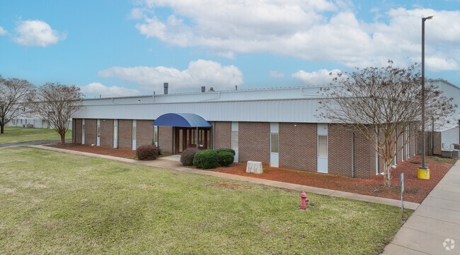
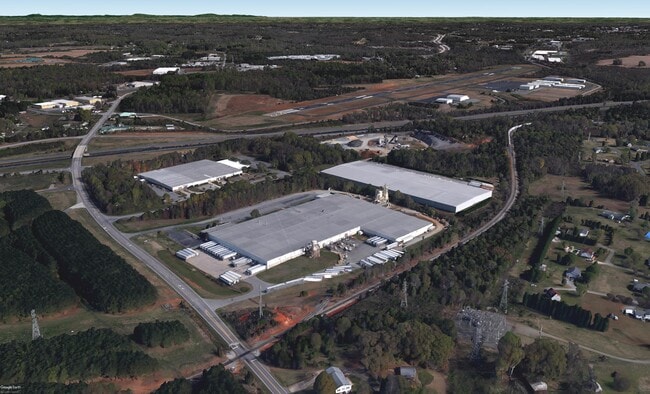
647 Hargrave Rd
06-005-0-000-0012-0-0-0
L12 BK2440-2470 HARGRAVE RD
Manufacturinglight
Davidson
I
North Carolina
B and X Area of moderate flood hazard, usually the area between the limits of the 100-year and 500-year floods.
20.01 AC
2025
South Davidson County
2025
Greensboro/Winston-Salem
061803
Winston-Salem, NC
214,592 SF
NEARBY LISTINGS FOR SALE OR LEASE
DEMOGRAPHICS near 647 Hargrave Rd
1 mile
3 mile
5 mile
2025 Total Population
330
8,589
32,326
2030 Population
345
9,086
34,269
Pop Growth 2025-2030
+ 4.55%
+ 5.79%
+ 6.01%
Average Age
41
41
41
2025 Total Households
131
3,379
12,905
HH Growth 2025-2030
+ 4.58%
+ 5.89%
+ 6.10%
Median Household Inc
$52,631
$63,250
$57,992
Avg Household Size
2.40
2.50
2.40
2025 Avg HH Vehicles
2.00
2.00
2.00
Median Home Value
$192,499
$209,375
$215,463
Median Year Built
1977
1986
1982
Nearby Places
Map Layers
Map Styles
 Street
 Aerial
Layers
 Traffic
 Biking
Places
Listings with unknown addresses are not visible on the map
- Restaurants
- Banks
- Shops
- Fitness
- Groceries
SALE & LEASE HISTORY
LISTING DATE
SALE/LEASE

Nov 16, 2020
For Lease
Jun 23, 2025
For Lease
Jul 08, 2025
For Lease
Jan 22, 2020
For Sale
Apr 10, 2024
For Lease
Nearby Properties
Address
Land Use
TOTAL SIZE
Lot Size
Zoning
Address
Land Use
TOTAL SIZE
Lot Size
Zoning
35,214 SF
149.11 AC
HI
Address
Land Use
TOTAL SIZE
Lot Size
Zoning
187,540 SF
26.94 AC
PD
Address
Land Use
TOTAL SIZE
Lot Size
Zoning
943,340 SF
202.76 AC
RA1
Address
Land Use
TOTAL SIZE
Lot Size
Zoning
22,560 SF
204.19 AC
I
Address
Land Use
TOTAL SIZE
Lot Size
Zoning
3,600 SF
198.35 AC
EC
Address
Land Use
TOTAL SIZE
Lot Size
Zoning
223,743 SF
99.83 AC
I
Address
Land Use
TOTAL SIZE
Lot Size
Zoning
3,156 SF
332.28 AC
HI
Address
Land Use
TOTAL SIZE
Lot Size
Zoning
2,821 SF
32.06 AC
TN
Address
Land Use
TOTAL SIZE
Lot Size
Zoning
9,728 SF
40.03 AC
RA1
Address
Land Use
TOTAL SIZE
Lot Size
Zoning
114,109 SF
20.39 AC
I
Address
Land Use
TOTAL SIZE
Lot Size
Zoning
116,842 SF
20.04 AC
I
Address
Land Use
TOTAL SIZE
Lot Size
Zoning
101,475 SF
108.36 AC
I
Address
Land Use
TOTAL SIZE
Lot Size
Zoning
6,000 SF
33.27 AC
HI
Address
Land Use
TOTAL SIZE
Lot Size
Zoning
66,594 SF
6.59 AC
OI
Address
Land Use
TOTAL SIZE
Lot Size
Zoning
68,288 SF
23.30 AC
LI
Address
Land Use
TOTAL SIZE
Lot Size
Zoning
103,720 SF
21.05 AC
I
Address
Land Use
TOTAL SIZE
Lot Size
Zoning
5,490 SF
212.79 AC
RA1
Address
Land Use
TOTAL SIZE
Lot Size
Zoning
131,100 SF
17.78 AC
I
Address
Land Use
TOTAL SIZE
Lot Size
Zoning
49,578 SF
7.74 AC
I
Address
Land Use
TOTAL SIZE
Lot Size
Zoning
201,600 SF
9.90 AC
I
Address
Land Use
TOTAL SIZE
Lot Size
Zoning
131,250 SF
14.30 AC
I
Address
Land Use
TOTAL SIZE
Lot Size
Zoning
23,572 SF
36.39 AC
I
Address
Land Use
TOTAL SIZE
Lot Size
Zoning
59,281 SF
4.34 AC
B
Address
Land Use
TOTAL SIZE
Lot Size
Zoning
313,535 SF
107.06 AC
I
Address
Land Use
TOTAL SIZE
Lot Size
Zoning
100,490 SF
18.18 AC
I
Address
Land Use
TOTAL SIZE
Lot Size
Zoning
29,925 SF
2.81 AC
OI
Address
Land Use
TOTAL SIZE
Lot Size
Zoning
157,650 SF
28.11 AC
LI
Address
Land Use
TOTAL SIZE
Lot Size
Zoning
115,838 SF
57.83 AC
I
Address
Land Use
TOTAL SIZE
Lot Size
Zoning
13,924 SF
5.35 AC
B
The World's #1 Commercial Real Estate Marketplace
Connect with us
© 2026 CoStar Group
The information above has been obtained from sources believed reliable. While we do not doubt its accuracy we have not verified it and make no guarantee, warranty or representation about it. It is your responsibility to independently confirm its accuracy and completeness. Any projections, opinions, assumptions, or estimates used are for example only and do not represent the current or future performance of the property. The value of this transaction to you depends on tax and other factors which should be evaluated by your tax, financial, and legal advisors. You and your advisors should conduct a careful, independent investigation of the property to determine to your satisfaction the suitability of the property for your needs.