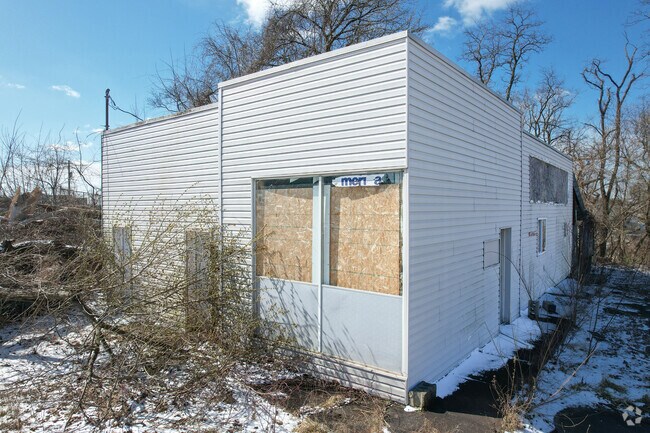
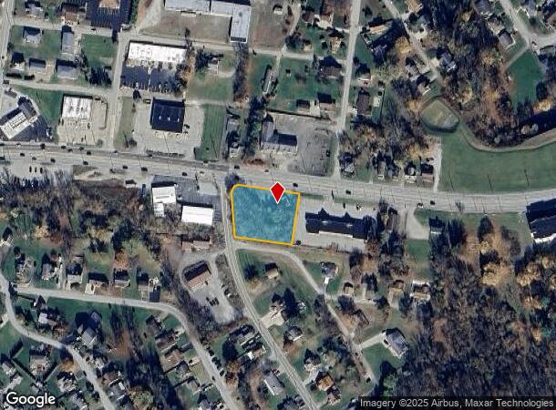
Property Record
6474 State Route 30, Jeannette, PA 15644
NEARBY LISTINGS FOR SALE OR LEASE
Property Detail
6474 State Route 30
50-13-12-0-110
LOT BLDG 188 SX 168 SX IR
Commercialofficeresidentialmixeduse
Westmoreland
X
Pennsylvania
42129C0415F
b
2025
0.77 AC
2025
Westmoreland County
804801
Pittsburgh
1,316 SF
Pittsburgh, PA
DEMOGRAPHICS near 6474 State Route 30
1 Mile
3 Mile
5 Mile
2024 Total Population
4,574
26,550
83,588
2029 Population
4,594
26,486
82,967
Pop Growth 2024-2029
+ 0.44%
(0.24%)
(0.74%)
Average Age
45
45
44
2024 Total Households
2,093
11,599
36,094
HH Growth 2024-2029
+ 0.33%
(0.30%)
(0.73%)
Median Household Inc
$51,025
$56,999
$62,692
Avg Household Size
2.10
2.20
2.20
2024 Avg HH Vehicles
2.00
2.00
2.00
Median Home Value
$125,535
$153,087
$179,139
Median Year Built
1957
1960
1964
Nearby Places
Map Layers
Map Styles
 Street
 Aerial
- Restaurants
- Banks
- Shops
- Fitness
- Groceries
PUBLIC TRANSPORTATION
COMMUTER RAIL
Greensburg Amtrak (Pennsylvanian - Amtrak)
DRIVE
WALK
Distance
Greensburg Amtrak (Pennsylvanian - Amtrak)
8 min
4.3 mi
AIRPORT
Arnold Palmer Regional
DRIVE
WALK
Distance
Arnold Palmer Regional
24 min
13.7 mi
Freight Ports
Port of Baltimore
DRIVE
WALK
Distance
Port of Baltimore
261 min
223.1 mi
SALE & LEASE HISTORY
LISTING DATE
SALE/LEASE

May 25, 2021
For Sale
Nearby Properties
Address
Land Use
TOTAL SIZE
Lot Size
Zoning
Address
Land Use
TOTAL SIZE
Lot Size
Zoning
103.80 AC
Address
Land Use
TOTAL SIZE
Lot Size
Zoning
Address
Land Use
TOTAL SIZE
Lot Size
Zoning
59,856 SF
15.90 AC
Address
Land Use
TOTAL SIZE
Lot Size
Zoning
214,781 SF
44.38 AC
Address
Land Use
TOTAL SIZE
Lot Size
Zoning
1.80 AC
Address
Land Use
TOTAL SIZE
Lot Size
Zoning
118,045 SF
16 AC
Address
Land Use
TOTAL SIZE
Lot Size
Zoning
11.71 AC
Address
Land Use
TOTAL SIZE
Lot Size
Zoning
101,104 SF
37.80 AC
Address
Land Use
TOTAL SIZE
Lot Size
Zoning
127,179 SF
25.84 AC
Address
Land Use
TOTAL SIZE
Lot Size
Zoning
45.37 AC
Address
Land Use
TOTAL SIZE
Lot Size
Zoning
21.20 AC
Address
Land Use
TOTAL SIZE
Lot Size
Zoning
515,280 SF
14.20 AC
Address
Land Use
TOTAL SIZE
Lot Size
Zoning
64,264 SF
2.20 AC
Address
Land Use
TOTAL SIZE
Lot Size
Zoning
Address
Land Use
TOTAL SIZE
Lot Size
Zoning
78,041 SF
10.78 AC
Address
Land Use
TOTAL SIZE
Lot Size
Zoning
159.10 AC
Address
Land Use
TOTAL SIZE
Lot Size
Zoning
Address
Land Use
TOTAL SIZE
Lot Size
Zoning
123,452 SF
10.85 AC
Address
Land Use
TOTAL SIZE
Lot Size
Zoning
11.02 AC
Address
Land Use
TOTAL SIZE
Lot Size
Zoning
317,355 SF
30.74 AC
Address
Land Use
TOTAL SIZE
Lot Size
Zoning
41,721 SF
5 AC
Address
Land Use
TOTAL SIZE
Lot Size
Zoning
64,548 SF
0.59 AC
Address
Land Use
TOTAL SIZE
Lot Size
Zoning
124,119 SF
12.22 AC
Address
Land Use
TOTAL SIZE
Lot Size
Zoning
13.52 AC
Address
Land Use
TOTAL SIZE
Lot Size
Zoning
2.28 AC
Address
Land Use
TOTAL SIZE
Lot Size
Zoning
27.70 AC
Address
Land Use
TOTAL SIZE
Lot Size
Zoning
23,730 SF
21.68 AC
Address
Land Use
TOTAL SIZE
Lot Size
Zoning
52,998 SF
9.94 AC
Address
Land Use
TOTAL SIZE
Lot Size
Zoning
11.37 AC
Address
Land Use
TOTAL SIZE
Lot Size
Zoning
3.30 AC
The World's #1 Commercial Real Estate Marketplace
Connect with us
© 2025 CoStar Group
The information above has been obtained from sources believed reliable. While we do not doubt its accuracy we have not verified it and make no guarantee, warranty or representation about it. It is your responsibility to independently confirm its accuracy and completeness. Any projections, opinions, assumptions, or estimates used are for example only and do not represent the current or future performance of the property. The value of this transaction to you depends on tax and other factors which should be evaluated by your tax, financial, and legal advisors. You and your advisors should conduct a careful, independent investigation of the property to determine to your satisfaction the suitability of the property for your needs.