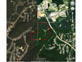
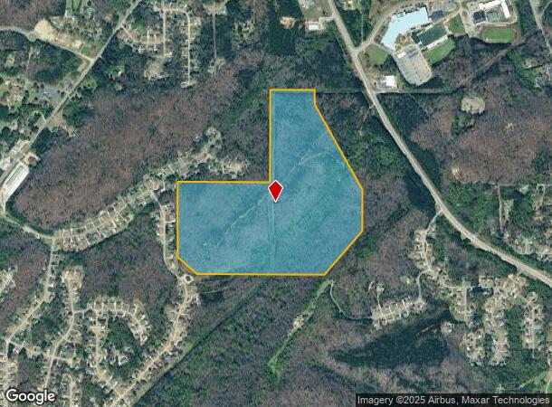
Property Record
6474 Walnut Way, Trussville, AL 35173
NEARBY LISTINGS FOR SALE OR LEASE
Property Detail
6474 Walnut Way
09-00-35-1-000-001.000
BEG NW COR OF NE 1/4 OF NE 1/4 SEC 35 TP 15 R 1W TH E 640 FT TH S 210 FT TH SELY 1410 FT TH S 600 FT TH SWLY 850 FT TH W 1850 FT TH NWLY 350 FT TH N 1080 FT TH E 1320 FT TH N 1330 FT TO POB
Vacantlandnec
Jefferson
X
Alabama
01073C0261J
104 AC
2023
Center Point
2024
Birmingham
011109
Birmingham-Hoover, AL
DEMOGRAPHICS near 6474 Walnut Way
1 Mile
3 Mile
5 Mile
2024 Total Population
1,773
14,017
49,706
2029 Population
1,724
13,576
48,363
Pop Growth 2024-2029
(2.76%)
(3.15%)
(2.70%)
Average Age
41
39
39
2024 Total Households
629
5,112
18,298
HH Growth 2024-2029
(2.86%)
(3.25%)
(2.78%)
Median Household Inc
$115,820
$76,968
$70,028
Avg Household Size
2.80
2.70
2.70
2024 Avg HH Vehicles
2.00
2.00
2.00
Median Home Value
$262,345
$190,125
$189,323
Median Year Built
1997
1992
1988
Nearby Places
Map Layers
Map Styles
 Street
 Aerial
- Restaurants
- Banks
- Shops
- Fitness
- Groceries
PUBLIC TRANSPORTATION
AIRPORT
Birmingham-Shuttlesworth International
DRIVE
WALK
Distance
Birmingham-Shuttlesworth International
27 min
14.8 mi
Freight Ports
Port of Mobile
DRIVE
WALK
Distance
Port of Mobile
302 min
272.6 mi
Nearby Properties
Address
Land Use
TOTAL SIZE
Lot Size
Zoning
Address
Land Use
TOTAL SIZE
Lot Size
Zoning
89,935 SF
29.32 AC
A1
Address
Land Use
TOTAL SIZE
Lot Size
Zoning
55,760 SF
24.85 AC
A1
Address
Land Use
TOTAL SIZE
Lot Size
Zoning
42,000 SF
5.10 AC
C1
Address
Land Use
TOTAL SIZE
Lot Size
Zoning
26,773 SF
22 AC
U1
Address
Land Use
TOTAL SIZE
Lot Size
Zoning
45,855 SF
5.41 AC
QC2
Address
Land Use
TOTAL SIZE
Lot Size
Zoning
45,629 SF
13.80 AC
INST
Address
Land Use
TOTAL SIZE
Lot Size
Zoning
38,817 SF
36.73 AC
INST
Address
Land Use
TOTAL SIZE
Lot Size
Zoning
21,627 SF
3.10 AC
C2
Address
Land Use
TOTAL SIZE
Lot Size
Zoning
38,364 SF
4.41 AC
R4
Address
Land Use
TOTAL SIZE
Lot Size
Zoning
43,697 SF
2.56 AC
R4C1
Address
Land Use
TOTAL SIZE
Lot Size
Zoning
15,023 SF
3.02 AC
A1
Address
Land Use
TOTAL SIZE
Lot Size
Zoning
3,360 SF
4.26 AC
Q-C2
Address
Land Use
TOTAL SIZE
Lot Size
Zoning
10,360 SF
1.26 AC
C1&A
Address
Land Use
TOTAL SIZE
Lot Size
Zoning
17,411 SF
11 AC
A1-I
Address
Land Use
TOTAL SIZE
Lot Size
Zoning
16,385 SF
2.20 AC
C1
Address
Land Use
TOTAL SIZE
Lot Size
Zoning
1,350 SF
96 AC
C1
Address
Land Use
TOTAL SIZE
Lot Size
Zoning
6,768 SF
1.92 AC
A1-R
Address
Land Use
TOTAL SIZE
Lot Size
Zoning
28,952 SF
5.40 AC
A1
Address
Land Use
TOTAL SIZE
Lot Size
Zoning
29,832 SF
7.70 AC
INST
Address
Land Use
TOTAL SIZE
Lot Size
Zoning
18,081 SF
5.90 AC
CP
Address
Land Use
TOTAL SIZE
Lot Size
Zoning
9,350 SF
1.97 AC
C2
Address
Land Use
TOTAL SIZE
Lot Size
Zoning
1,716 SF
14.28 AC
C1
Address
Land Use
TOTAL SIZE
Lot Size
Zoning
7,438 SF
1.20 AC
A1
Address
Land Use
TOTAL SIZE
Lot Size
Zoning
8,220 SF
1.02 AC
C-P
Address
Land Use
TOTAL SIZE
Lot Size
Zoning
14,340 SF
2.14 AC
INST
Address
Land Use
TOTAL SIZE
Lot Size
Zoning
11,334 SF
4.17 AC
INST
Address
Land Use
TOTAL SIZE
Lot Size
Zoning
13,840 SF
1.67 AC
A1
Address
Land Use
TOTAL SIZE
Lot Size
Zoning
10.63 AC
C2
Address
Land Use
TOTAL SIZE
Lot Size
Zoning
2,790 SF
0.93 AC
QC2
The World's #1 Commercial Real Estate Marketplace
Connect with us
© 2025 CoStar Group
The information above has been obtained from sources believed reliable. While we do not doubt its accuracy we have not verified it and make no guarantee, warranty or representation about it. It is your responsibility to independently confirm its accuracy and completeness. Any projections, opinions, assumptions, or estimates used are for example only and do not represent the current or future performance of the property. The value of this transaction to you depends on tax and other factors which should be evaluated by your tax, financial, and legal advisors. You and your advisors should conduct a careful, independent investigation of the property to determine to your satisfaction the suitability of the property for your needs.