Property Record
6475 Airways Blvd, Southaven, MS 38671

This Property Is For Sale
NEARBY LISTINGS FOR SALE OR LEASE
Property Detail
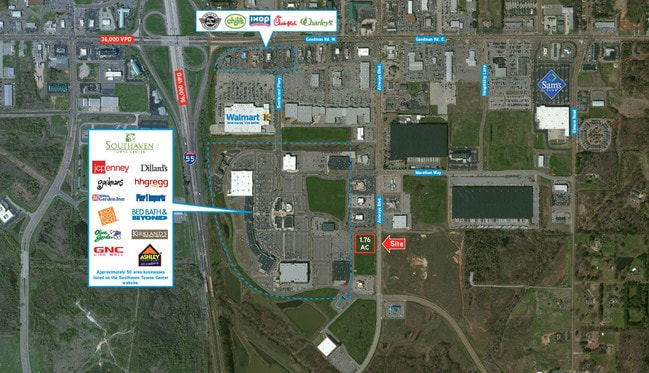
6475 Airways Blvd
Memphis, TN-MS-AR
Southaven Towne Center 1St Rev
1087361000000300
SOUTHAVEN TOWNE CENTER LOT 3
Vacantlandnec
DeSoto
X
Mississippi
28033C0078H
3
2025
1.76 AC
2025
DeSoto County
070610
Memphis
DEMOGRAPHICS near 6475 Airways Blvd
1 Mile
3 Mile
5 Mile
2024 Total Population
3,780
48,388
107,577
2029 Population
4,124
53,190
115,753
Pop Growth 2024-2029
+ 9.10%
+ 9.92%
+ 7.60%
Average Age
37
38
38
2024 Total Households
1,621
18,945
40,259
HH Growth 2024-2029
+ 9.25%
+ 10.03%
+ 7.66%
Median Household Inc
$47,760
$52,021
$57,936
Avg Household Size
2.30
2.50
2.60
2024 Avg HH Vehicles
2.00
2.00
2.00
Median Home Value
$170,844
$168,435
$188,543
Median Year Built
1989
1992
1991
Nearby Places
Map Layers
Map Styles
 Street
 Aerial
- Restaurants
- Banks
- Shops
- Fitness
- Groceries
PUBLIC TRANSPORTATION
AIRPORT
Memphis International
DRIVE
WALK
Distance
Memphis International
13 min
7.9 mi
Freight Ports
Port of Shreveport
DRIVE
WALK
Distance
Port of Shreveport
415 min
382.6 mi
Nearby Properties
Address
Land Use
TOTAL SIZE
Lot Size
Zoning
Address
Land Use
TOTAL SIZE
Lot Size
Zoning
732,894 SF
79.73 AC
WD
Address
Land Use
TOTAL SIZE
Lot Size
Zoning
1,021,440 SF
57.67 AC
M-1
Address
Land Use
TOTAL SIZE
Lot Size
Zoning
1,197,486 SF
59.47 AC
PBP
Address
Land Use
TOTAL SIZE
Lot Size
Zoning
906,200 SF
73.05 AC
PBP
Address
Land Use
TOTAL SIZE
Lot Size
Zoning
864,024 SF
51.02 AC
PBP
Address
Land Use
TOTAL SIZE
Lot Size
Zoning
946,430 SF
62.60 AC
PBP
Address
Land Use
TOTAL SIZE
Lot Size
Zoning
23,183 SF
33.02 AC
PUD
Address
Land Use
TOTAL SIZE
Lot Size
Zoning
188,404 SF
59.17 AC
R-8
Address
Land Use
TOTAL SIZE
Lot Size
Zoning
842,678 SF
51 AC
PBP
Address
Land Use
TOTAL SIZE
Lot Size
Zoning
412,218 SF
37.80 AC
PBP
Address
Land Use
TOTAL SIZE
Lot Size
Zoning
581,346 SF
39.98 AC
PUD
Address
Land Use
TOTAL SIZE
Lot Size
Zoning
62,561 SF
33.01 AC
PUD
Address
Land Use
TOTAL SIZE
Lot Size
Zoning
864,160 SF
44.14 AC
PBP
Address
Land Use
TOTAL SIZE
Lot Size
Zoning
18,830 SF
25.45 AC
PUD
Address
Land Use
TOTAL SIZE
Lot Size
Zoning
740,964 SF
34.89 AC
PBP
Address
Land Use
TOTAL SIZE
Lot Size
Zoning
473,820 SF
56.29 AC
PBP
Address
Land Use
TOTAL SIZE
Lot Size
Zoning
15,472 SF
25.97 AC
PUD
Address
Land Use
TOTAL SIZE
Lot Size
Zoning
779,632 SF
46.22 AC
PBP
Address
Land Use
TOTAL SIZE
Lot Size
Zoning
581,530 SF
51.64 AC
PBP
Address
Land Use
TOTAL SIZE
Lot Size
Zoning
222,932 SF
19.52 AC
C-1
Address
Land Use
TOTAL SIZE
Lot Size
Zoning
702,792 SF
37.11 AC
PBP
Address
Land Use
TOTAL SIZE
Lot Size
Zoning
619,021 SF
28.71 AC
PBP
Address
Land Use
TOTAL SIZE
Lot Size
Zoning
601,700 SF
29.51 AC
PBP
Address
Land Use
TOTAL SIZE
Lot Size
Zoning
14,122 SF
24 AC
PUD
Address
Land Use
TOTAL SIZE
Lot Size
Zoning
519,647 SF
29.67 AC
PBP
Address
Land Use
TOTAL SIZE
Lot Size
Zoning
554,433 SF
24.57 AC
PBP
Address
Land Use
TOTAL SIZE
Lot Size
Zoning
553,179 SF
36.77 AC
PBP
Address
Land Use
TOTAL SIZE
Lot Size
Zoning
514,885 SF
35.91 AC
PBP
Address
Land Use
TOTAL SIZE
Lot Size
Zoning
454,272 SF
22.28 AC
PBP
Address
Land Use
TOTAL SIZE
Lot Size
Zoning
12,775 SF
26.29 AC
PUD
The World's #1 Commercial Real Estate Marketplace
Connect with us
© 2025 CoStar Group
The information above has been obtained from sources believed reliable. While we do not doubt its accuracy we have not verified it and make no guarantee, warranty or representation about it. It is your responsibility to independently confirm its accuracy and completeness. Any projections, opinions, assumptions, or estimates used are for example only and do not represent the current or future performance of the property. The value of this transaction to you depends on tax and other factors which should be evaluated by your tax, financial, and legal advisors. You and your advisors should conduct a careful, independent investigation of the property to determine to your satisfaction the suitability of the property for your needs.