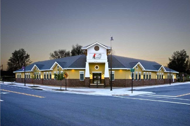
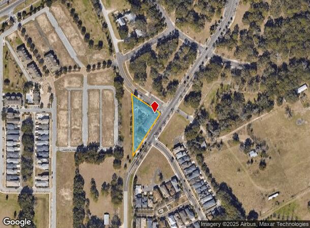
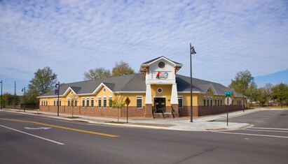
Property Record
6476 Sw 75Th St, Gainesville, FL 32608
NEARBY LISTINGS FOR SALE OR LEASE
-
-
View all Gainesville listings for sale on LoopNet.com
Property Detail
6476 Sw 75Th St
Gainesville, FL
Brytan
07027-004-000
COM SE COR LOT 1 BRYTAN PH 1 PB 27 PG 58 S 57 DEG 34 MIN 03 SEC E 30 FT S 32 DEG 25 MIN 57 SEC W 87 FT POB S 32 DEG 25 MIN 57 SEC W 333.36 FT N 00 DEG 21 MIN 32 SEC W 2.45 FT N 00 DEG 17 MIN 45 SEC W 222.01 FT NWLY ALG CURVE 190.79 FT SELY ALG CURVE
Privateschool
Alachua
X
Florida
12001C0435E
1
2025
0.87 AC
2025
South Gainesville
002220
Other Market Areas
8,601 SF
DEMOGRAPHICS near 6476 Sw 75Th St
1 mile
3 mile
5 mile
2024 Total Population
6,854
29,447
93,683
2029 Population
7,243
31,559
98,904
Pop Growth 2024-2029
+ 5.68%
+ 7.17%
+ 5.57%
Average Age
38
39
35
2024 Total Households
2,782
11,966
38,530
HH Growth 2024-2029
+ 5.79%
+ 7.38%
+ 5.59%
Median Household Inc
$89,079
$94,212
$53,387
Avg Household Size
2.40
2.40
2.20
2024 Avg HH Vehicles
2.00
2.00
2.00
Median Home Value
$309,362
$337,623
$316,357
Median Year Built
1997
1998
1992
Nearby Places
Map Layers
Map Styles
 Street
 Aerial
Transit
 Traffic
 Biking
Places
Listings with unknown addresses are not visible on the map
- Restaurants
- Banks
- Shops
- Fitness
- Groceries
PUBLIC TRANSPORTATION
AIRPORT
Gainesville Regional
Drive
Walk
Distance
Gainesville Regional
28 min
12.8 mi
Freight Ports
Jacksonville Port
Drive
Walk
Distance
Jacksonville Port
113 min
82.6 mi
Nearby Properties
Address
Land Use
TOTAL SIZE
Lot Size
Zoning
Address
Land Use
TOTAL SIZE
Lot Size
Zoning
170,185 SF
5.14 AC
R-1AA
Address
Land Use
TOTAL SIZE
Lot Size
Zoning
371,933 SF
15 AC
PD
Address
Land Use
TOTAL SIZE
Lot Size
Zoning
332,878 SF
34.15 AC
PD
Address
Land Use
TOTAL SIZE
Lot Size
Zoning
205,412 SF
23.80 AC
R-1A
Address
Land Use
TOTAL SIZE
Lot Size
Zoning
309,967 SF
12.58 AC
PD
Address
Land Use
TOTAL SIZE
Lot Size
Zoning
134,068 SF
3.47 AC
R-2
Address
Land Use
TOTAL SIZE
Lot Size
Zoning
311,673 SF
34.15 AC
R-2
Address
Land Use
TOTAL SIZE
Lot Size
Zoning
307,316 SF
25.99 AC
R-2
Address
Land Use
TOTAL SIZE
Lot Size
Zoning
29,190 SF
4.21 AC
BI
Address
Land Use
TOTAL SIZE
Lot Size
Zoning
112,213 SF
18.62 AC
R-1AA
Address
Land Use
TOTAL SIZE
Lot Size
Zoning
87,104 SF
14.59 AC
PD
Address
Land Use
TOTAL SIZE
Lot Size
Zoning
311,290 SF
25.20 AC
R-1A
Address
Land Use
TOTAL SIZE
Lot Size
Zoning
97,648 SF
44.62 AC
A
Address
Land Use
TOTAL SIZE
Lot Size
Zoning
102,304 SF
2.79 AC
BUS
Address
Land Use
TOTAL SIZE
Lot Size
Zoning
168,512 SF
15.22 AC
R-2
Address
Land Use
TOTAL SIZE
Lot Size
Zoning
103,808 SF
5.66 AC
BI
Address
Land Use
TOTAL SIZE
Lot Size
Zoning
168,512 SF
4.78 AC
R-2
Address
Land Use
TOTAL SIZE
Lot Size
Zoning
92,735 SF
1.07 AC
R-1A
Address
Land Use
TOTAL SIZE
Lot Size
Zoning
64,710 SF
8.30 AC
PD
Address
Land Use
TOTAL SIZE
Lot Size
Zoning
133,104 SF
66.88 AC
RM
Address
Land Use
TOTAL SIZE
Lot Size
Zoning
150,324 SF
3.22 AC
R-1AA
Address
Land Use
TOTAL SIZE
Lot Size
Zoning
405,996 SF
2.35 AC
R-1AA
Address
Land Use
TOTAL SIZE
Lot Size
Zoning
86,343 SF
4.03 AC
BI
Address
Land Use
TOTAL SIZE
Lot Size
Zoning
12,738 SF
55.78 AC
MD
Address
Land Use
TOTAL SIZE
Lot Size
Zoning
73,224 SF
2.56 AC
BI
Address
Land Use
TOTAL SIZE
Lot Size
Zoning
49,400 SF
41.99 AC
RM
Address
Land Use
TOTAL SIZE
Lot Size
Zoning
98,278 SF
3.40 AC
MP
Address
Land Use
TOTAL SIZE
Lot Size
Zoning
42,290 SF
2.43 AC
BUS
Address
Land Use
TOTAL SIZE
Lot Size
Zoning
97,174 SF
11.94 AC
PD
Address
Land Use
TOTAL SIZE
Lot Size
Zoning
59,960 SF
1.91 AC
BI
The World's #1 Commercial Real Estate Marketplace
Connect with us
© 2026 CoStar Group
The information above has been obtained from sources believed reliable. While we do not doubt its accuracy we have not verified it and make no guarantee, warranty or representation about it. It is your responsibility to independently confirm its accuracy and completeness. Any projections, opinions, assumptions, or estimates used are for example only and do not represent the current or future performance of the property. The value of this transaction to you depends on tax and other factors which should be evaluated by your tax, financial, and legal advisors. You and your advisors should conduct a careful, independent investigation of the property to determine to your satisfaction the suitability of the property for your needs.