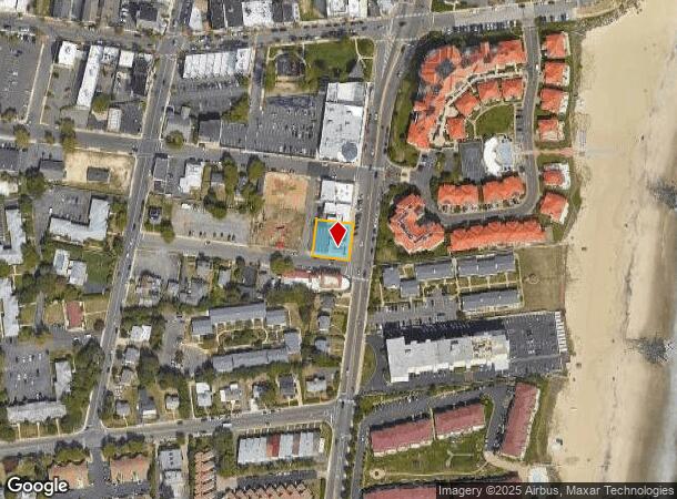
Property Record
648 Ocean Ave, Long Branch, NJ 07740
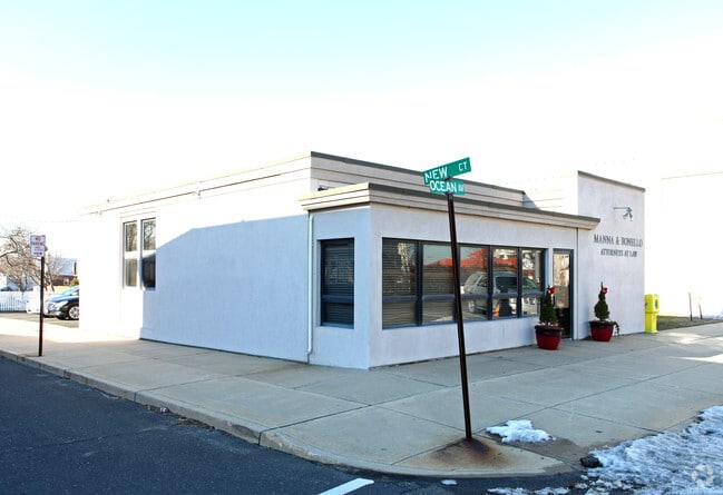
This Property Is For Sale
NEARBY LISTINGS FOR SALE OR LEASE
Property Detail
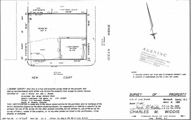
648 Ocean Ave
27-00090-0000-00003
Monmouth
Officebuilding
New Jersey
X
3
34025C0211F
0.18 AC
2024
Eastern Monmouth
2025
Northern New Jersey
806000
New York-Jersey City-White Plains, NY-NJ
2,682 SF
DEMOGRAPHICS near 648 Ocean Ave
1 Mile
3 Mile
5 Mile
2024 Total Population
10,962
55,409
119,082
2029 Population
11,263
56,059
119,766
Pop Growth 2024-2029
+ 2.75%
+ 1.17%
+ 0.57%
Average Age
41
40
42
2024 Total Households
4,722
20,545
48,248
HH Growth 2024-2029
+ 3.09%
+ 1.31%
+ 0.58%
Median Household Inc
$53,426
$77,276
$84,490
Avg Household Size
2.20
2.50
2.40
2024 Avg HH Vehicles
1.00
2.00
2.00
Median Home Value
$602,051
$570,473
$585,128
Median Year Built
1967
1967
1968
Nearby Places
- Restaurants
- Banks
- Shops
- Fitness
- Groceries
PUBLIC TRANSPORTATION
COMMUTER RAIL
Long Branch (North Jersey Coast Line - NJ Transit Commuter Rail (NJ Transit))
DRIVE
WALK
Distance
Long Branch (North Jersey Coast Line - NJ Transit Commuter Rail (NJ Transit))
3 min
1.6 mi
Elberon (North Jersey Coast Line - NJ Transit Commuter Rail (NJ Transit))
DRIVE
WALK
Distance
Elberon (North Jersey Coast Line - NJ Transit Commuter Rail (NJ Transit))
4 min
1.9 mi
AIRPORT
Newark Liberty International
DRIVE
WALK
Distance
Newark Liberty International
61 min
49.0 mi
Freight Ports
New York Container Terminal
DRIVE
WALK
Distance
New York Container Terminal
55 min
41.1 mi
Nearby Properties
Address
Land Use
TOTAL SIZE
Lot Size
Zoning
Address
Land Use
TOTAL SIZE
Lot Size
Zoning
13.75 AC
M
Address
Land Use
TOTAL SIZE
Lot Size
Zoning
7,819 SF
28.41 AC
R-1
Address
Land Use
TOTAL SIZE
Lot Size
Zoning
89,939 SF
51.49 AC
I
Address
Land Use
TOTAL SIZE
Lot Size
Zoning
279,346 SF
3.59 AC
P/VC
Address
Land Use
TOTAL SIZE
Lot Size
Zoning
267,887 SF
13.45 AC
HC
Address
Land Use
TOTAL SIZE
Lot Size
Zoning
136.40 AC
B2
Address
Land Use
TOTAL SIZE
Lot Size
Zoning
22,877 SF
10.35 AC
IC
Address
Land Use
TOTAL SIZE
Lot Size
Zoning
194,784 SF
2.88 AC
P/VC
Address
Land Use
TOTAL SIZE
Lot Size
Zoning
2,446 SF
21.62 AC
R-5
Address
Land Use
TOTAL SIZE
Lot Size
Zoning
293,262 SF
28.40 AC
HC
Address
Land Use
TOTAL SIZE
Lot Size
Zoning
314,569 SF
22.05 AC
R-4
Address
Land Use
TOTAL SIZE
Lot Size
Zoning
79,391 SF
9.17 AC
C-4
Address
Land Use
TOTAL SIZE
Lot Size
Zoning
5,904 SF
29.80 AC
S-2
Address
Land Use
TOTAL SIZE
Lot Size
Zoning
194,812 SF
55.01 AC
R-4
Address
Land Use
TOTAL SIZE
Lot Size
Zoning
2.19 AC
BG
Address
Land Use
TOTAL SIZE
Lot Size
Zoning
16.49 AC
R-2
Address
Land Use
TOTAL SIZE
Lot Size
Zoning
137,672 SF
2.79 AC
BS
Address
Land Use
TOTAL SIZE
Lot Size
Zoning
121,272 SF
3.93 AC
C-4
Address
Land Use
TOTAL SIZE
Lot Size
Zoning
14.23 AC
R-4
Address
Land Use
TOTAL SIZE
Lot Size
Zoning
77.36 AC
B2
Address
Land Use
TOTAL SIZE
Lot Size
Zoning
157,580 SF
14.95 AC
R-4
Address
Land Use
TOTAL SIZE
Lot Size
Zoning
0.13 AC
BS
Address
Land Use
TOTAL SIZE
Lot Size
Zoning
40.82 AC
I
Address
Land Use
TOTAL SIZE
Lot Size
Zoning
108,629 SF
12.05 AC
HC
Address
Land Use
TOTAL SIZE
Lot Size
Zoning
22,522 SF
6.25 AC
I
Address
Land Use
TOTAL SIZE
Lot Size
Zoning
10.47 AC
R-7
Address
Land Use
TOTAL SIZE
Lot Size
Zoning
2,788 SF
1.55 AC
R-1
Address
Land Use
TOTAL SIZE
Lot Size
Zoning
1.53 AC
R-1
Address
Land Use
TOTAL SIZE
Lot Size
Zoning
73,032 SF
7.30 AC
B1
Address
Land Use
TOTAL SIZE
Lot Size
Zoning
59,104 SF
1.27 AC
P/VC
The World's #1 Commercial Real Estate Marketplace
Connect with us
© 2025 CoStar Group
The information above has been obtained from sources believed reliable. While we do not doubt its accuracy we have not verified it and make no guarantee, warranty or representation about it. It is your responsibility to independently confirm its accuracy and completeness. Any projections, opinions, assumptions, or estimates used are for example only and do not represent the current or future performance of the property. The value of this transaction to you depends on tax and other factors which should be evaluated by your tax, financial, and legal advisors. You and your advisors should conduct a careful, independent investigation of the property to determine to your satisfaction the suitability of the property for your needs.