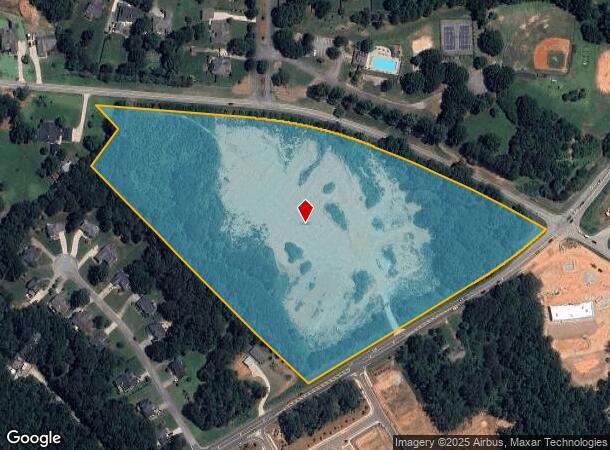
Property Record
6482 Mcever Rd, Flowery Branch, GA 30542


NEARBY LISTINGS FOR SALE OR LEASE
Property Detail
6482 Mcever Rd
08-00140-00-218
16.093 AC
Commercialacreage
Hall
X
Georgia
13139C0292G
16.09 AC
2025
Gainesville/Hall County
2025
Atlanta
001502
Gainesville, GA
DEMOGRAPHICS near 6482 Mcever Rd
1 Mile
3 Mile
5 Mile
2024 Total Population
4,192
22,718
65,183
2029 Population
4,675
25,288
71,706
Pop Growth 2024-2029
+ 11.52%
+ 11.31%
+ 10.01%
Average Age
42
40
39
2024 Total Households
1,469
8,244
22,530
HH Growth 2024-2029
+ 11.44%
+ 11.32%
+ 10.19%
Median Household Inc
$97,744
$75,178
$83,041
Avg Household Size
2.90
2.70
2.90
2024 Avg HH Vehicles
3.00
2.00
2.00
Median Home Value
$325,186
$309,557
$321,735
Median Year Built
2000
1999
2000
Nearby Places
Map Layers
Map Styles
 Street
 Aerial
- Restaurants
- Banks
- Shops
- Fitness
- Groceries
SALE & LEASE HISTORY
LISTING DATE
SALE/LEASE

Apr 16, 2019
For Lease
Nearby Properties
Address
Land Use
TOTAL SIZE
Lot Size
Zoning
Address
Land Use
TOTAL SIZE
Lot Size
Zoning
285,000 SF
97.06 AC
M-I
Address
Land Use
TOTAL SIZE
Lot Size
Zoning
5,760 SF
38.07 AC
R-III
Address
Land Use
TOTAL SIZE
Lot Size
Zoning
815,563 SF
58.80 AC
M-I
Address
Land Use
TOTAL SIZE
Lot Size
Zoning
101,632 SF
78.33 AC
M-I
Address
Land Use
TOTAL SIZE
Lot Size
Zoning
85,900 SF
25.29 AC
H-B
Address
Land Use
TOTAL SIZE
Lot Size
Zoning
213,532 SF
44.32 AC
M-I
Address
Land Use
TOTAL SIZE
Lot Size
Zoning
224,093 SF
33.94 AC
M-I
Address
Land Use
TOTAL SIZE
Lot Size
Zoning
447,120 SF
35 AC
M-1
Address
Land Use
TOTAL SIZE
Lot Size
Zoning
264,600 SF
10.27 AC
M1
Address
Land Use
TOTAL SIZE
Lot Size
Zoning
143,000 SF
41.30 AC
M-I
Address
Land Use
TOTAL SIZE
Lot Size
Zoning
458,256 SF
26.39 AC
M-I
Address
Land Use
TOTAL SIZE
Lot Size
Zoning
261,368 SF
5.80 AC
M-I
Address
Land Use
TOTAL SIZE
Lot Size
Zoning
269,130 SF
25.34 AC
M-1
Address
Land Use
TOTAL SIZE
Lot Size
Zoning
300,000 SF
23.03 AC
M-II
Address
Land Use
TOTAL SIZE
Lot Size
Zoning
194,748 SF
1.09 AC
PCD
Address
Land Use
TOTAL SIZE
Lot Size
Zoning
158,900 SF
13.94 AC
M-II
Address
Land Use
TOTAL SIZE
Lot Size
Zoning
6,400 SF
0.03 AC
V-C
Address
Land Use
TOTAL SIZE
Lot Size
Zoning
120,204 SF
14.77 AC
H-B
Address
Land Use
TOTAL SIZE
Lot Size
Zoning
18,408 SF
15.50 AC
L-I
Address
Land Use
TOTAL SIZE
Lot Size
Zoning
96.39 AC
M1
Address
Land Use
TOTAL SIZE
Lot Size
Zoning
125,400 SF
21.87 AC
MUNI
Address
Land Use
TOTAL SIZE
Lot Size
Zoning
112,308 SF
12.48 AC
M-1
Address
Land Use
TOTAL SIZE
Lot Size
Zoning
126,112 SF
9.63 AC
H-B
Address
Land Use
TOTAL SIZE
Lot Size
Zoning
80,164 SF
8.72 AC
H-B
Address
Land Use
TOTAL SIZE
Lot Size
Zoning
164,704 SF
10.26 AC
C1
Address
Land Use
TOTAL SIZE
Lot Size
Zoning
68,974 SF
9.81 AC
H-B
Address
Land Use
TOTAL SIZE
Lot Size
Zoning
76.34 AC
M-1
Address
Land Use
TOTAL SIZE
Lot Size
Zoning
7,332 SF
0.28 AC
V-C
Address
Land Use
TOTAL SIZE
Lot Size
Zoning
59,172 SF
3.25 AC
M1
Address
Land Use
TOTAL SIZE
Lot Size
Zoning
87,502 SF
6.58 AC
H-B
The World's #1 Commercial Real Estate Marketplace
Connect with us
© 2026 CoStar Group
The information above has been obtained from sources believed reliable. While we do not doubt its accuracy we have not verified it and make no guarantee, warranty or representation about it. It is your responsibility to independently confirm its accuracy and completeness. Any projections, opinions, assumptions, or estimates used are for example only and do not represent the current or future performance of the property. The value of this transaction to you depends on tax and other factors which should be evaluated by your tax, financial, and legal advisors. You and your advisors should conduct a careful, independent investigation of the property to determine to your satisfaction the suitability of the property for your needs.