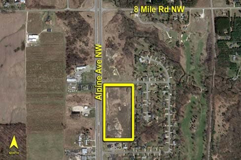
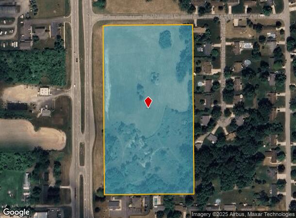
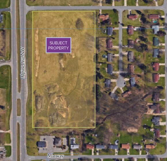
Property Record
6484 Alpine Ave Nw, Comstock Park, MI 49321
NEARBY LISTINGS FOR SALE OR LEASE
Property Detail
6484 Alpine Ave Nw
Grand Rapids-Wyoming, MI
PART W 1/2 NW 1/4 COM 1363.60 FT N ALONG W SEC LINE FROM W 1/4 COR TH E TO NW COR OF LOT 67 OF MARWAY PLAT NO.4 TH S ALONG W
41-09-13-195-035
Kent
Commercialacreage
Michigan
X
67
26081C0280D
13.28 AC
2024
Comstock/Alpine
2025
West Michigan
011401
DEMOGRAPHICS near 6484 Alpine Ave Nw
1 Mile
3 Mile
5 Mile
2024 Total Population
572
14,020
45,532
2029 Population
575
14,075
45,749
Pop Growth 2024-2029
+ 0.52%
+ 0.39%
+ 0.48%
Average Age
41
40
39
2024 Total Households
215
5,548
18,284
HH Growth 2024-2029
+ 0.47%
+ 0.40%
+ 0.51%
Median Household Inc
$65,689
$75,067
$69,128
Avg Household Size
2.50
2.50
2.40
2024 Avg HH Vehicles
2.00
2.00
2.00
Median Home Value
$251,492
$243,100
$244,469
Median Year Built
1974
1984
1981
Nearby Places
Map Layers
Map Styles
 Street
 Aerial
- Restaurants
- Banks
- Shops
- Fitness
- Groceries
PUBLIC TRANSPORTATION
AIRPORT
Gerald R Ford International
DRIVE
WALK
Distance
Gerald R Ford International
32 min
22.6 mi
Freight Ports
Port Milwaukee
DRIVE
WALK
Distance
Port Milwaukee
317 min
271.3 mi
SALE & LEASE HISTORY
LISTING DATE
SALE/LEASE

Sep 24, 2016
For Sale
Nearby Properties
Address
Land Use
TOTAL SIZE
Lot Size
Zoning
Address
Land Use
TOTAL SIZE
Lot Size
Zoning
169,898 SF
Address
Land Use
TOTAL SIZE
Lot Size
Zoning
Address
Land Use
TOTAL SIZE
Lot Size
Zoning
9.11 AC
R-3
Address
Land Use
TOTAL SIZE
Lot Size
Zoning
8.77 AC
R-3
Address
Land Use
TOTAL SIZE
Lot Size
Zoning
100,800 SF
I-1
Address
Land Use
TOTAL SIZE
Lot Size
Zoning
Address
Land Use
TOTAL SIZE
Lot Size
Zoning
2,676 SF
12.32 AC
R-3
Address
Land Use
TOTAL SIZE
Lot Size
Zoning
11.39 AC
R-3
Address
Land Use
TOTAL SIZE
Lot Size
Zoning
Address
Land Use
TOTAL SIZE
Lot Size
Zoning
117,225 SF
22.01 AC
I-1
Address
Land Use
TOTAL SIZE
Lot Size
Zoning
171,155 SF
14.47 AC
I-2
Address
Land Use
TOTAL SIZE
Lot Size
Zoning
53.97 AC
Address
Land Use
TOTAL SIZE
Lot Size
Zoning
16.45 AC
Address
Land Use
TOTAL SIZE
Lot Size
Zoning
20.20 AC
Address
Land Use
TOTAL SIZE
Lot Size
Zoning
97,078 SF
10.67 AC
C-PUD
Address
Land Use
TOTAL SIZE
Lot Size
Zoning
44,455 SF
6.77 AC
I-1
Address
Land Use
TOTAL SIZE
Lot Size
Zoning
145,739 SF
42.40 AC
I-2
Address
Land Use
TOTAL SIZE
Lot Size
Zoning
21,000 SF
2.78 AC
C-PUD
Address
Land Use
TOTAL SIZE
Lot Size
Zoning
81,168 SF
8.04 AC
I-2
Address
Land Use
TOTAL SIZE
Lot Size
Zoning
Address
Land Use
TOTAL SIZE
Lot Size
Zoning
95,524 SF
20 AC
I-1
Address
Land Use
TOTAL SIZE
Lot Size
Zoning
6.56 AC
Address
Land Use
TOTAL SIZE
Lot Size
Zoning
4.14 AC
R-3
Address
Land Use
TOTAL SIZE
Lot Size
Zoning
64,548 SF
5.34 AC
I-1
Address
Land Use
TOTAL SIZE
Lot Size
Zoning
6.53 AC
R-3
Address
Land Use
TOTAL SIZE
Lot Size
Zoning
Address
Land Use
TOTAL SIZE
Lot Size
Zoning
3.86 AC
R-3
Address
Land Use
TOTAL SIZE
Lot Size
Zoning
17.70 AC
Address
Land Use
TOTAL SIZE
Lot Size
Zoning
33,400 SF
Address
Land Use
TOTAL SIZE
Lot Size
Zoning
277,050 SF
40 AC
A
The World's #1 Commercial Real Estate Marketplace
Connect with us
© 2025 CoStar Group
The information above has been obtained from sources believed reliable. While we do not doubt its accuracy we have not verified it and make no guarantee, warranty or representation about it. It is your responsibility to independently confirm its accuracy and completeness. Any projections, opinions, assumptions, or estimates used are for example only and do not represent the current or future performance of the property. The value of this transaction to you depends on tax and other factors which should be evaluated by your tax, financial, and legal advisors. You and your advisors should conduct a careful, independent investigation of the property to determine to your satisfaction the suitability of the property for your needs.