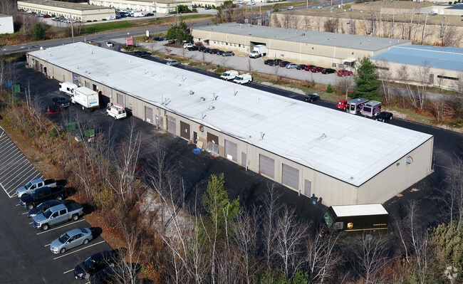
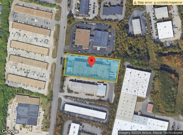
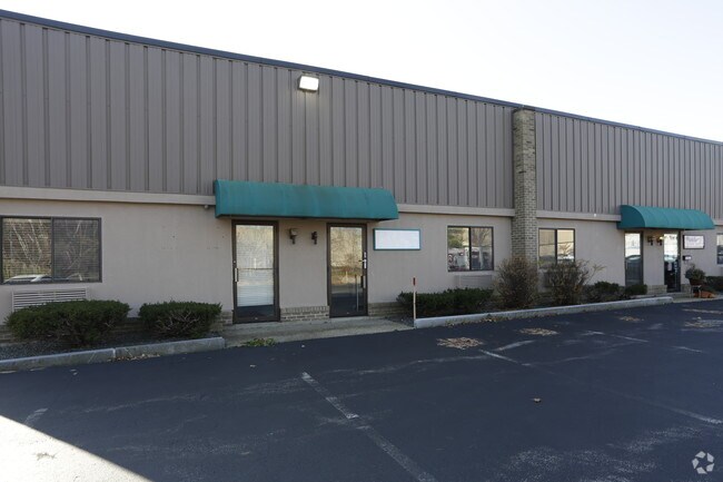
Property Record
649 E East Industrial Park Dr, Manchester, NH 03109
NEARBY LISTINGS FOR SALE OR LEASE
Property Detail
649 E East Industrial Park Dr
Industrialcondominium
Hillsborough
X
New Hampshire
33011C0381D
1
2024
Hillsborough
2024
Boston
001000
Manchester-Nashua, NH
1,200 SF
MNCH-000727A-000000-000001
DEMOGRAPHICS near 649 E East Industrial Park Dr
1 Mile
3 Mile
5 Mile
2024 Total Population
5,278
65,744
130,528
2029 Population
5,364
66,639
133,027
Pop Growth 2024-2029
+ 1.63%
+ 1.36%
+ 1.91%
Average Age
44
40
40
2024 Total Households
2,067
27,351
53,895
HH Growth 2024-2029
+ 1.74%
+ 1.38%
+ 1.92%
Median Household Inc
$99,819
$71,971
$75,974
Avg Household Size
2.40
2.30
2.30
2024 Avg HH Vehicles
2.00
2.00
2.00
Median Home Value
$311,372
$299,218
$328,574
Median Year Built
1965
1962
1968
Nearby Places
Map Layers
Map Styles
 Street
 Aerial
- Restaurants
- Banks
- Shops
- Fitness
- Groceries
PUBLIC TRANSPORTATION
AIRPORT
Manchester Boston Regional
DRIVE
WALK
Distance
Manchester Boston Regional
16 min
7.2 mi
Portsmouth International at Pease
DRIVE
WALK
Distance
Portsmouth International at Pease
59 min
44.7 mi
Freight Ports
Port of Boston
DRIVE
WALK
Distance
Port of Boston
68 min
52.4 mi
SALE & LEASE HISTORY
LISTING DATE
SALE/LEASE

Nov 14, 2019
For Lease
Jan 23, 2019
For Lease
Nearby Properties
Address
Land Use
TOTAL SIZE
Lot Size
Zoning
Address
Land Use
TOTAL SIZE
Lot Size
Zoning
446,957 SF
24.16 AC
Address
Land Use
TOTAL SIZE
Lot Size
Zoning
383,493 SF
34.51 AC
Address
Land Use
TOTAL SIZE
Lot Size
Zoning
6,830 SF
17.24 AC
Address
Land Use
TOTAL SIZE
Lot Size
Zoning
256,041 SF
6.69 AC
Address
Land Use
TOTAL SIZE
Lot Size
Zoning
8,064 SF
34.29 AC
Address
Land Use
TOTAL SIZE
Lot Size
Zoning
135,686 SF
30.23 AC
Address
Land Use
TOTAL SIZE
Lot Size
Zoning
217,697 SF
43.25 AC
Address
Land Use
TOTAL SIZE
Lot Size
Zoning
229,089 SF
3.58 AC
Address
Land Use
TOTAL SIZE
Lot Size
Zoning
135,879 SF
2.36 AC
Address
Land Use
TOTAL SIZE
Lot Size
Zoning
22,101 SF
8.33 AC
Address
Land Use
TOTAL SIZE
Lot Size
Zoning
49,788 SF
34.73 AC
Address
Land Use
TOTAL SIZE
Lot Size
Zoning
237,634 SF
5.39 AC
Address
Land Use
TOTAL SIZE
Lot Size
Zoning
24,064 SF
19.44 AC
Address
Land Use
TOTAL SIZE
Lot Size
Zoning
211,525 SF
93.01 AC
Address
Land Use
TOTAL SIZE
Lot Size
Zoning
165,000 SF
3.38 AC
Address
Land Use
TOTAL SIZE
Lot Size
Zoning
180,474 SF
18.60 AC
Address
Land Use
TOTAL SIZE
Lot Size
Zoning
230,582 SF
0.31 AC
Address
Land Use
TOTAL SIZE
Lot Size
Zoning
2,218 SF
17.11 AC
Address
Land Use
TOTAL SIZE
Lot Size
Zoning
148,880 SF
2.38 AC
Address
Land Use
TOTAL SIZE
Lot Size
Zoning
Address
Land Use
TOTAL SIZE
Lot Size
Zoning
38,506 SF
9.88 AC
Address
Land Use
TOTAL SIZE
Lot Size
Zoning
171,811 SF
44.42 AC
Address
Land Use
TOTAL SIZE
Lot Size
Zoning
6,110 SF
12.99 AC
Address
Land Use
TOTAL SIZE
Lot Size
Zoning
114,380 SF
7.64 AC
Address
Land Use
TOTAL SIZE
Lot Size
Zoning
162,272 SF
9.69 AC
Address
Land Use
TOTAL SIZE
Lot Size
Zoning
123,966 SF
13 AC
Address
Land Use
TOTAL SIZE
Lot Size
Zoning
90,323 SF
0.92 AC
Address
Land Use
TOTAL SIZE
Lot Size
Zoning
92,492 SF
85 AC
Address
Land Use
TOTAL SIZE
Lot Size
Zoning
112,851 SF
10.93 AC
Address
Land Use
TOTAL SIZE
Lot Size
Zoning
134,586 SF
14.84 AC
The World's #1 Commercial Real Estate Marketplace
Connect with us
© 2025 CoStar Group
The information above has been obtained from sources believed reliable. While we do not doubt its accuracy we have not verified it and make no guarantee, warranty or representation about it. It is your responsibility to independently confirm its accuracy and completeness. Any projections, opinions, assumptions, or estimates used are for example only and do not represent the current or future performance of the property. The value of this transaction to you depends on tax and other factors which should be evaluated by your tax, financial, and legal advisors. You and your advisors should conduct a careful, independent investigation of the property to determine to your satisfaction the suitability of the property for your needs.