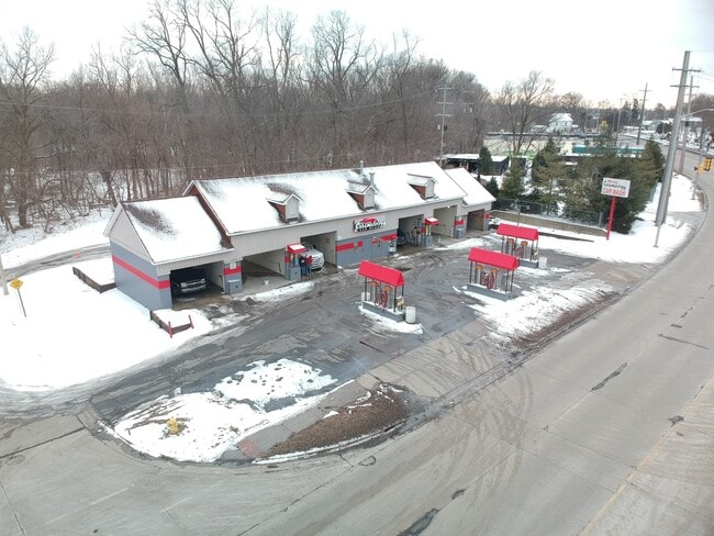
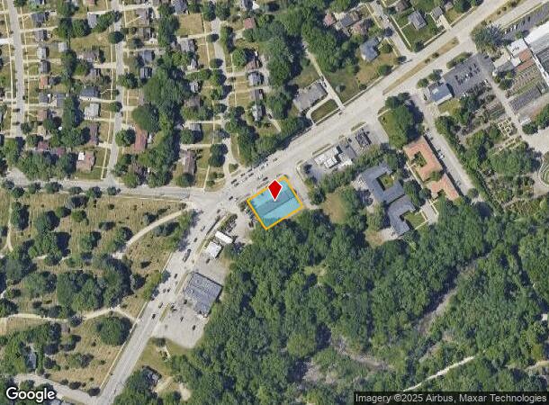
Property Record
649 Orchard Lake Rd, Pontiac, MI 48341
NEARBY LISTINGS FOR SALE OR LEASE
Property Detail
649 Orchard Lake Rd
Detroit-Warren-Dearborn, MI
Pontiac
14-31-256-006
T3N, R10E, SEC 31 ROBERT HERNDON'S PONTIAC APARTMENT SUBDIVISION LOTS 13 TO 19 INCL, ALSO 1/2 OF VAC ALLEY ADJ TO SAME 12-2-08 CORR
Commercialnec
Oakland
X
Michigan
26125C0364F
13-19
2024
0.35 AC
2024
Pontiac
142500
Detroit
3,332 SF
DEMOGRAPHICS near 649 Orchard Lake Rd
1 Mile
3 Mile
5 Mile
2024 Total Population
10,607
72,179
161,722
2029 Population
10,688
72,230
161,146
Pop Growth 2024-2029
+ 0.76%
+ 0.07%
(0.36%)
Average Age
40
40
41
2024 Total Households
4,468
30,047
66,434
HH Growth 2024-2029
+ 0.69%
+ 0.03%
(0.39%)
Median Household Inc
$46,351
$48,470
$62,783
Avg Household Size
2.20
2.30
2.30
2024 Avg HH Vehicles
2.00
2.00
2.00
Median Home Value
$131,648
$165,240
$238,048
Median Year Built
1951
1962
1968
Nearby Places
Map Layers
Map Styles
 Street
 Aerial
- Restaurants
- Banks
- Shops
- Fitness
- Groceries
PUBLIC TRANSPORTATION
COMMUTER RAIL
Pontiac Amtrak Station (Wolverine - Amtrak)
DRIVE
WALK
Distance
Pontiac Amtrak Station (Wolverine - Amtrak)
3 min
1.3 mi
AIRPORT
Detroit Metro Wayne County
DRIVE
WALK
Distance
Detroit Metro Wayne County
55 min
39.4 mi
Freight Ports
Port of Toledo
DRIVE
WALK
Distance
Port of Toledo
104 min
81.1 mi
SALE & LEASE HISTORY
LISTING DATE
SALE/LEASE

May 10, 2018
For Sale
Feb 27, 2025
For Sale
Apr 20, 2020
For Sale
Nearby Properties
Address
Land Use
TOTAL SIZE
Lot Size
Zoning
Address
Land Use
TOTAL SIZE
Lot Size
Zoning
526,398 SF
32.99 AC
Address
Land Use
TOTAL SIZE
Lot Size
Zoning
1,771,589 SF
96.73 AC
Address
Land Use
TOTAL SIZE
Lot Size
Zoning
608,251 SF
50.49 AC
II
Address
Land Use
TOTAL SIZE
Lot Size
Zoning
481,186 SF
42.14 AC
AI
Address
Land Use
TOTAL SIZE
Lot Size
Zoning
374,400 SF
4.10 AC
Address
Land Use
TOTAL SIZE
Lot Size
Zoning
426,034 SF
24.99 AC
AI
Address
Land Use
TOTAL SIZE
Lot Size
Zoning
601,151 SF
Address
Land Use
TOTAL SIZE
Lot Size
Zoning
221,340 SF
26.88 AC
Address
Land Use
TOTAL SIZE
Lot Size
Zoning
156,668 SF
13.19 AC
BI
Address
Land Use
TOTAL SIZE
Lot Size
Zoning
23.28 AC
AI
Address
Land Use
TOTAL SIZE
Lot Size
Zoning
97,172 SF
13.82 AC
BI
Address
Land Use
TOTAL SIZE
Lot Size
Zoning
101,320 SF
28.20 AC
Address
Land Use
TOTAL SIZE
Lot Size
Zoning
79,263 SF
22.27 AC
Address
Land Use
TOTAL SIZE
Lot Size
Zoning
903,018 SF
73.92 AC
II
Address
Land Use
TOTAL SIZE
Lot Size
Zoning
145,712 SF
10.51 AC
BV
Address
Land Use
TOTAL SIZE
Lot Size
Zoning
87,560 SF
7.94 AC
BI
Address
Land Use
TOTAL SIZE
Lot Size
Zoning
288,124 SF
15.76 AC
Address
Land Use
TOTAL SIZE
Lot Size
Zoning
93,706 SF
1.13 AC
Address
Land Use
TOTAL SIZE
Lot Size
Zoning
55,912 SF
1.11 AC
Address
Land Use
TOTAL SIZE
Lot Size
Zoning
143,701 SF
9.85 AC
AI
Address
Land Use
TOTAL SIZE
Lot Size
Zoning
89,442 SF
9.21 AC
BI
Address
Land Use
TOTAL SIZE
Lot Size
Zoning
562,472 SF
39.69 AC
Address
Land Use
TOTAL SIZE
Lot Size
Zoning
96,587 SF
5 AC
BI
Address
Land Use
TOTAL SIZE
Lot Size
Zoning
137,256 SF
14.97 AC
BI
Address
Land Use
TOTAL SIZE
Lot Size
Zoning
64,053 SF
2.69 AC
Address
Land Use
TOTAL SIZE
Lot Size
Zoning
88,110 SF
3.15 AC
AI
Address
Land Use
TOTAL SIZE
Lot Size
Zoning
1,332,530 SF
95.81 AC
Address
Land Use
TOTAL SIZE
Lot Size
Zoning
211,861 SF
2.69 AC
BI
Address
Land Use
TOTAL SIZE
Lot Size
Zoning
55,269 SF
5.40 AC
BI
Address
Land Use
TOTAL SIZE
Lot Size
Zoning
80,600 SF
51.48 AC
The World's #1 Commercial Real Estate Marketplace
Connect with us
© 2025 CoStar Group
The information above has been obtained from sources believed reliable. While we do not doubt its accuracy we have not verified it and make no guarantee, warranty or representation about it. It is your responsibility to independently confirm its accuracy and completeness. Any projections, opinions, assumptions, or estimates used are for example only and do not represent the current or future performance of the property. The value of this transaction to you depends on tax and other factors which should be evaluated by your tax, financial, and legal advisors. You and your advisors should conduct a careful, independent investigation of the property to determine to your satisfaction the suitability of the property for your needs.