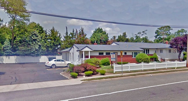
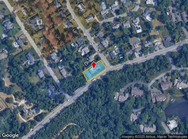
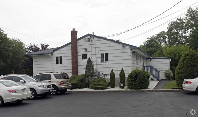
Property Record
649 W Montauk Hwy, Bay Shore, NY 11706

NEARBY LISTINGS FOR SALE OR LEASE
Property Detail
649 W Montauk Hwy
Nassau County-Suffolk County, NY
Map Lousyl Manor Section Two
0500-458-00-01-00-009-000
X2201441Y174929 N055N00000000WL
Commercialbuilding
Suffolk
X
New York
36103C0859H
100
0
0.52 AC
2024
Southwestern Suffolk
147003
Long Island (New York)
DEMOGRAPHICS near 649 W Montauk Hwy
1 Mile
3 Mile
5 Mile
2024 Total Population
6,685
70,533
194,346
2029 Population
6,596
69,243
189,747
Pop Growth 2024-2029
(1.33%)
(1.83%)
(2.37%)
Average Age
43
41
40
2024 Total Households
2,332
23,802
62,741
HH Growth 2024-2029
(1.59%)
(1.98%)
(2.48%)
Median Household Inc
$131,485
$123,240
$116,060
Avg Household Size
2.80
2.80
3.00
2024 Avg HH Vehicles
2.00
2.00
2.00
Median Home Value
$635,209
$489,992
$458,872
Median Year Built
1961
1958
1961
Nearby Places
- Restaurants
- Banks
- Shops
- Fitness
- Groceries
PUBLIC TRANSPORTATION
COMMUTER RAIL
Bay Shore Station (Montauk Branch - Long Island Rail Road)
DRIVE
WALK
Distance
Bay Shore Station (Montauk Branch - Long Island Rail Road)
4 min
2.2 mi
Babylon Station (Babylon Branch - Long Island Rail Road, Montauk Branch - Long Island Rail Road)
DRIVE
WALK
Distance
Babylon Station (Babylon Branch - Long Island Rail Road, Montauk Branch - Long Island Rail Road)
6 min
3.2 mi
AIRPORT
Long Island MacArthur
DRIVE
WALK
Distance
Long Island MacArthur
23 min
13.7 mi
John F Kennedy International
DRIVE
WALK
Distance
John F Kennedy International
45 min
32.7 mi
Freight Ports
NY - Red Hook Container Terminal
DRIVE
WALK
Distance
NY - Red Hook Container Terminal
66 min
44.1 mi
SALE & LEASE HISTORY
LISTING DATE
SALE/LEASE

Jan 09, 2019
For Sale
Feb 08, 2023
For Lease
Apr 03, 2025
For Lease
Nearby Properties
Address
Land Use
TOTAL SIZE
Lot Size
Zoning
Address
Land Use
TOTAL SIZE
Lot Size
Zoning
48.97 AC
GSC
Address
Land Use
TOTAL SIZE
Lot Size
Zoning
86.63 AC
Address
Land Use
TOTAL SIZE
Lot Size
Zoning
18.89 AC
Address
Land Use
TOTAL SIZE
Lot Size
Zoning
256 SF
24.20 AC
GSC
Address
Land Use
TOTAL SIZE
Lot Size
Zoning
20 AC
A
Address
Land Use
TOTAL SIZE
Lot Size
Zoning
10.07 AC
Address
Land Use
TOTAL SIZE
Lot Size
Zoning
28.40 AC
A
Address
Land Use
TOTAL SIZE
Lot Size
Zoning
1,400 SF
10.27 AC
BD
Address
Land Use
TOTAL SIZE
Lot Size
Zoning
15 AC
B
Address
Land Use
TOTAL SIZE
Lot Size
Zoning
19.56 AC
BUS3
Address
Land Use
TOTAL SIZE
Lot Size
Zoning
20.50 AC
B
Address
Land Use
TOTAL SIZE
Lot Size
Zoning
15 AC
A
Address
Land Use
TOTAL SIZE
Lot Size
Zoning
231.30 AC
AAA
Address
Land Use
TOTAL SIZE
Lot Size
Zoning
20.10 AC
A
Address
Land Use
TOTAL SIZE
Lot Size
Zoning
19.60 AC
BUS3
Address
Land Use
TOTAL SIZE
Lot Size
Zoning
4,290 SF
1.50 AC
VILLA
Address
Land Use
TOTAL SIZE
Lot Size
Zoning
10.44 AC
BUS3
Address
Land Use
TOTAL SIZE
Lot Size
Zoning
18.70 AC
A
Address
Land Use
TOTAL SIZE
Lot Size
Zoning
9.70 AC
B
Address
Land Use
TOTAL SIZE
Lot Size
Zoning
6.66 AC
A
Address
Land Use
TOTAL SIZE
Lot Size
Zoning
19.70 AC
B
Address
Land Use
TOTAL SIZE
Lot Size
Zoning
1.80 AC
Address
Land Use
TOTAL SIZE
Lot Size
Zoning
9.80 AC
AA
Address
Land Use
TOTAL SIZE
Lot Size
Zoning
2.33 AC
DDD278
Address
Land Use
TOTAL SIZE
Lot Size
Zoning
10.22 AC
IBD
Address
Land Use
TOTAL SIZE
Lot Size
Zoning
14.60 AC
A
Address
Land Use
TOTAL SIZE
Lot Size
Zoning
13.30 AC
A
Address
Land Use
TOTAL SIZE
Lot Size
Zoning
10.90 AC
IND1
Address
Land Use
TOTAL SIZE
Lot Size
Zoning
9.70 AC
B
Address
Land Use
TOTAL SIZE
Lot Size
Zoning
19.40 AC
IND1
The World's #1 Commercial Real Estate Marketplace
Connect with us
© 2025 CoStar Group
The information above has been obtained from sources believed reliable. While we do not doubt its accuracy we have not verified it and make no guarantee, warranty or representation about it. It is your responsibility to independently confirm its accuracy and completeness. Any projections, opinions, assumptions, or estimates used are for example only and do not represent the current or future performance of the property. The value of this transaction to you depends on tax and other factors which should be evaluated by your tax, financial, and legal advisors. You and your advisors should conduct a careful, independent investigation of the property to determine to your satisfaction the suitability of the property for your needs.