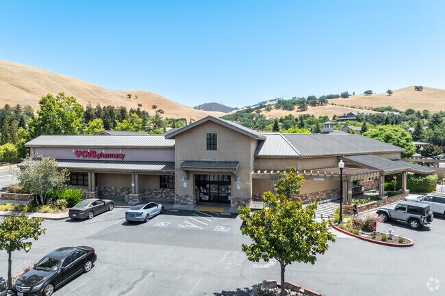
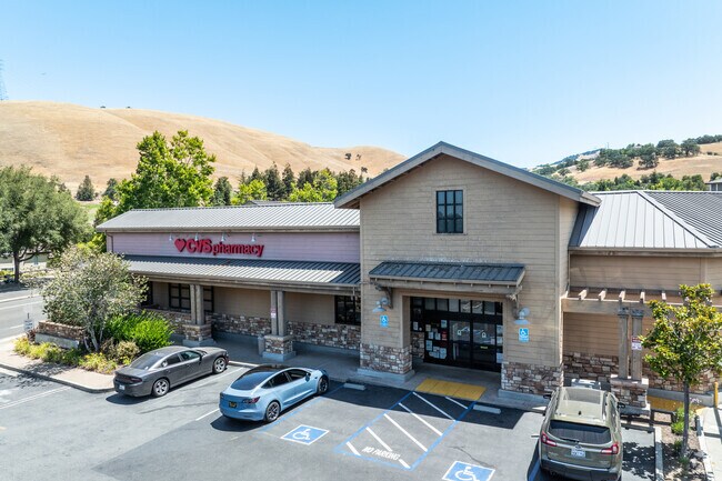
Property Record
6490 Clayton Rd, Clayton, CA 94517

Property Detail
6490 Clayton Rd
118-560-021-8
PARCEL MAP MS376-99
Storebuilding
CONTRA COSTA
B and X Area of moderate flood hazard, usually the area between the limits of the 100-year and 500-year floods.
California
2025
0.97 AC
2025
Concord/Pleasant Hill
355308
East Bay/Oakland
13,857 SF
Oakland-Fremont-Berkeley, CA
NEARBY LISTINGS FOR SALE OR LEASE
-
-
View all Clayton listings for sale on LoopNet.com
DEMOGRAPHICS near 6490 Clayton Rd
1 mile
3 mile
5 mile
2025 Total Population
8,415
35,449
99,255
2030 Population
8,426
35,506
99,700
Pop Growth 2025-2030
+ 0.13%
+ 0.16%
+ 0.45%
Average Age
45
44
43
2025 Total Households
3,133
13,140
35,244
HH Growth 2025-2030
+ 0.16%
+ 0.18%
+ 0.45%
Median Household Inc
$173,108
$137,939
$136,260
Avg Household Size
2.70
2.70
2.80
2025 Avg HH Vehicles
2.00
2.00
2.00
Median Home Value
$973,309
$853,780
$836,326
Median Year Built
1985
1976
1974
Nearby Places
Map Layers
Map Styles
 Street
 Aerial
Layers
 Traffic
 Biking
Places
Listings with unknown addresses are not visible on the map
- Restaurants
- Banks
- Shops
- Fitness
- Groceries
PUBLIC TRANSPORTATION
AIRPORT
Metro Oakland International
Drive
Walk
Distance
Metro Oakland International
49 min
33.2 mi
Freight Ports
Port of Oakland
Drive
Walk
Distance
Port of Oakland
39 min
26.0 mi
Nearby Properties
Address
Land Use
TOTAL SIZE
Lot Size
Zoning
Address
Land Use
TOTAL SIZE
Lot Size
Zoning
180,705 SF
4.66 AC
Address
Land Use
TOTAL SIZE
Lot Size
Zoning
57.97 AC
Address
Land Use
TOTAL SIZE
Lot Size
Zoning
6,269 SF
4.40 AC
Address
Land Use
TOTAL SIZE
Lot Size
Zoning
9,272 SF
7.32 AC
Address
Land Use
TOTAL SIZE
Lot Size
Zoning
6,496 SF
7.99 AC
Address
Land Use
TOTAL SIZE
Lot Size
Zoning
42,164 SF
8.27 AC
Address
Land Use
TOTAL SIZE
Lot Size
Zoning
13,548 SF
4.87 AC
Address
Land Use
TOTAL SIZE
Lot Size
Zoning
74,716 SF
6.32 AC
Address
Land Use
TOTAL SIZE
Lot Size
Zoning
14,090 SF
8.79 AC
Address
Land Use
TOTAL SIZE
Lot Size
Zoning
61,012 SF
4.95 AC
Address
Land Use
TOTAL SIZE
Lot Size
Zoning
90,271 SF
12.83 AC
Address
Land Use
TOTAL SIZE
Lot Size
Zoning
53,867 SF
4.56 AC
Address
Land Use
TOTAL SIZE
Lot Size
Zoning
144,600 SF
4.48 AC
Address
Land Use
TOTAL SIZE
Lot Size
Zoning
0.40 AC
Address
Land Use
TOTAL SIZE
Lot Size
Zoning
79.31 AC
A4
Address
Land Use
TOTAL SIZE
Lot Size
Zoning
16,515 SF
61.37 AC
Address
Land Use
TOTAL SIZE
Lot Size
Zoning
8,772 SF
8.31 AC
Address
Land Use
TOTAL SIZE
Lot Size
Zoning
6,000 SF
2.73 AC
Address
Land Use
TOTAL SIZE
Lot Size
Zoning
57,354 SF
2.86 AC
Address
Land Use
TOTAL SIZE
Lot Size
Zoning
66,375 SF
1.72 AC
Address
Land Use
TOTAL SIZE
Lot Size
Zoning
61,845 SF
1.52 AC
Address
Land Use
TOTAL SIZE
Lot Size
Zoning
865.42 AC
Address
Land Use
TOTAL SIZE
Lot Size
Zoning
1,949 SF
379.30 AC
Address
Land Use
TOTAL SIZE
Lot Size
Zoning
8,715 SF
1.25 AC
Address
Land Use
TOTAL SIZE
Lot Size
Zoning
22,920 SF
1.30 AC
Address
Land Use
TOTAL SIZE
Lot Size
Zoning
13,997 SF
0.34 AC
Address
Land Use
TOTAL SIZE
Lot Size
Zoning
181.72 AC
A2
Address
Land Use
TOTAL SIZE
Lot Size
Zoning
16,370 SF
1.28 AC
Address
Land Use
TOTAL SIZE
Lot Size
Zoning
3,000 SF
1.58 AC
Address
Land Use
TOTAL SIZE
Lot Size
Zoning
9,168 SF
1.29 AC
The World's #1 Commercial Real Estate Marketplace
Connect with us
© 2026 CoStar Group
The information above has been obtained from sources believed reliable. While we do not doubt its accuracy we have not verified it and make no guarantee, warranty or representation about it. It is your responsibility to independently confirm its accuracy and completeness. Any projections, opinions, assumptions, or estimates used are for example only and do not represent the current or future performance of the property. The value of this transaction to you depends on tax and other factors which should be evaluated by your tax, financial, and legal advisors. You and your advisors should conduct a careful, independent investigation of the property to determine to your satisfaction the suitability of the property for your needs.