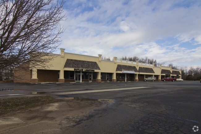
Property Record
6495 Shallowford Rd, Lewisville, NC 27023

NEARBY LISTINGS FOR SALE OR LEASE
-
-
View all Lewisville listings for lease on LoopNet.com
Property Detail
6495 Shallowford Rd
Winston-Salem, NC
Lewisville Center
5885-07-3401
LEWISVILLE CENTER LO:006B BL:4612 BU:1
Storebuilding
Forsyth
X
North Carolina
3710588500J
6b
2024
5.43 AC
2025
Western Forsyth County
004009
Greensboro/Winston-Salem
3,848 SF
DEMOGRAPHICS near 6495 Shallowford Rd
1 Mile
3 Mile
5 Mile
2024 Total Population
3,013
20,824
58,927
2029 Population
3,145
21,782
61,328
Pop Growth 2024-2029
+ 4.38%
+ 4.60%
+ 4.07%
Average Age
41
42
42
2024 Total Households
1,198
8,052
24,039
HH Growth 2024-2029
+ 4.34%
+ 4.58%
+ 4.04%
Median Household Inc
$90,086
$98,672
$88,386
Avg Household Size
2.50
2.60
2.40
2024 Avg HH Vehicles
2.00
2.00
2.00
Median Home Value
$314,545
$316,383
$303,858
Median Year Built
1990
1991
1989
Nearby Places
Map Layers
Map Styles
 Street
 Aerial
- Restaurants
- Banks
- Shops
- Fitness
- Groceries
PUBLIC TRANSPORTATION
AIRPORT
Piedmont Triad International
DRIVE
WALK
Distance
Piedmont Triad International
46 min
35.0 mi
SALE & LEASE HISTORY
LISTING DATE
SALE/LEASE

Sep 25, 2016
For Lease
Nearby Properties
Address
Land Use
TOTAL SIZE
Lot Size
Zoning
Address
Land Use
TOTAL SIZE
Lot Size
Zoning
124,972 SF
19.32 AC
MU-S
Address
Land Use
TOTAL SIZE
Lot Size
Zoning
189,737 SF
20.53 AC
CD1-S
Address
Land Use
TOTAL SIZE
Lot Size
Zoning
200,651 SF
60 AC
IP
Address
Land Use
TOTAL SIZE
Lot Size
Zoning
402,885 SF
19.63 AC
HB-S
Address
Land Use
TOTAL SIZE
Lot Size
Zoning
69,992 SF
16.14 AC
RM8
Address
Land Use
TOTAL SIZE
Lot Size
Zoning
152,991 SF
13.94 AC
HB-S
Address
Land Use
TOTAL SIZE
Lot Size
Zoning
89,335 SF
44.77 AC
IP
Address
Land Use
TOTAL SIZE
Lot Size
Zoning
75,991 SF
8.68 AC
PB-S,RM12
Address
Land Use
TOTAL SIZE
Lot Size
Zoning
54,297 SF
8.44 AC
HB-S
Address
Land Use
TOTAL SIZE
Lot Size
Zoning
52,208 SF
33.17 AC
RM12
Address
Land Use
TOTAL SIZE
Lot Size
Zoning
67,804 SF
10.88 AC
IP
Address
Land Use
TOTAL SIZE
Lot Size
Zoning
42,287 SF
4.42 AC
HB-S
Address
Land Use
TOTAL SIZE
Lot Size
Zoning
20,616 SF
4.71 AC
PB,RS9
Address
Land Use
TOTAL SIZE
Lot Size
Zoning
12,776 SF
30.92 AC
HB-S
Address
Land Use
TOTAL SIZE
Lot Size
Zoning
67,736 SF
13.40 AC
HB
Address
Land Use
TOTAL SIZE
Lot Size
Zoning
39,429 SF
7.82 AC
HB,HB-S
Address
Land Use
TOTAL SIZE
Lot Size
Zoning
22,818 SF
3.31 AC
IP
Address
Land Use
TOTAL SIZE
Lot Size
Zoning
11,770 SF
31.20 AC
IP
Address
Land Use
TOTAL SIZE
Lot Size
Zoning
15,150 SF
0.95 AC
IP
Address
Land Use
TOTAL SIZE
Lot Size
Zoning
17,422 SF
2.63 AC
LD1-S
Address
Land Use
TOTAL SIZE
Lot Size
Zoning
11,354 SF
0.49 AC
IP
Address
Land Use
TOTAL SIZE
Lot Size
Zoning
59,838 SF
4.86 AC
HB
Address
Land Use
TOTAL SIZE
Lot Size
Zoning
28,659 SF
5.67 AC
RM8-S
Address
Land Use
TOTAL SIZE
Lot Size
Zoning
22,902 SF
5.20 AC
RM12-S
Address
Land Use
TOTAL SIZE
Lot Size
Zoning
5,886 SF
2.17 AC
HB-S
Address
Land Use
TOTAL SIZE
Lot Size
Zoning
14,553 SF
1.68 AC
HB-S
Address
Land Use
TOTAL SIZE
Lot Size
Zoning
33,585 SF
NULL
Address
Land Use
TOTAL SIZE
Lot Size
Zoning
84.82 AC
MU-S
Address
Land Use
TOTAL SIZE
Lot Size
Zoning
36,420 SF
3.50 AC
HB,RS9
Address
Land Use
TOTAL SIZE
Lot Size
Zoning
11,200 SF
1.63 AC
HB-S
The World's #1 Commercial Real Estate Marketplace
Connect with us
© 2026 CoStar Group
The information above has been obtained from sources believed reliable. While we do not doubt its accuracy we have not verified it and make no guarantee, warranty or representation about it. It is your responsibility to independently confirm its accuracy and completeness. Any projections, opinions, assumptions, or estimates used are for example only and do not represent the current or future performance of the property. The value of this transaction to you depends on tax and other factors which should be evaluated by your tax, financial, and legal advisors. You and your advisors should conduct a careful, independent investigation of the property to determine to your satisfaction the suitability of the property for your needs.