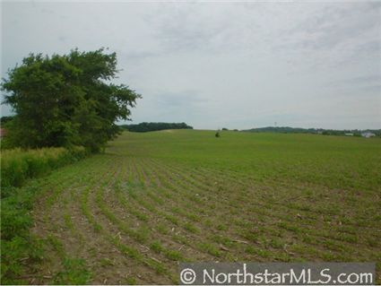
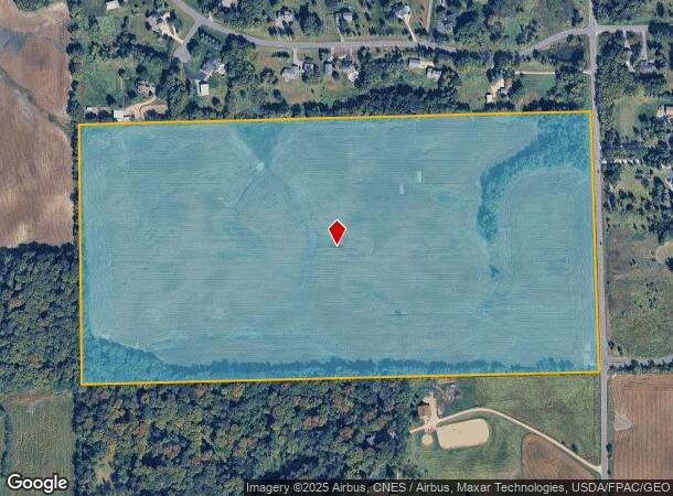
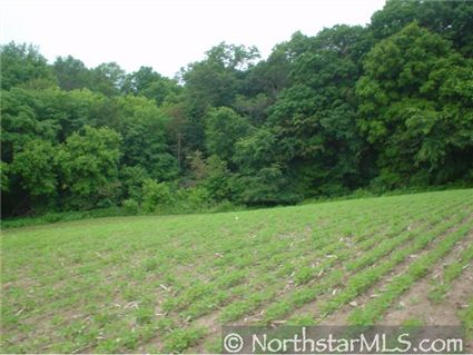
Property Record
65 Address Unassigned St, Rockford, MN 55373
NEARBY LISTINGS FOR SALE OR LEASE
Property Detail
65 Address Unassigned St
Minneapolis-St. Paul-Bloomington, MN-WI
Unplatted 21 119 24
21-119-24-43-0001
UNPLATTED 21 119 24 S 1/2 OF SE 1/4 EX ROAD IRREGULAR
Farms
Hennepin
X
Minnesota
27053C0127F
77.53 AC
2024
Northwest
2024
Minneapolis/St Paul
027001
DEMOGRAPHICS near 65 Address Unassigned St
1 Mile
3 Mile
5 Mile
2024 Total Population
802
8,223
16,804
2029 Population
806
8,805
17,911
Pop Growth 2024-2029
+ 0.50%
+ 7.08%
+ 6.59%
Average Age
41
40
40
2024 Total Households
300
3,099
6,090
HH Growth 2024-2029
+ 0.67%
+ 7.36%
+ 6.63%
Median Household Inc
$108,593
$97,189
$108,585
Avg Household Size
2.70
2.70
2.70
2024 Avg HH Vehicles
2.00
2.00
2.00
Median Home Value
$402,500
$319,502
$363,432
Median Year Built
1986
1993
1992
Nearby Places
Map Layers
Map Styles
 Street
 Aerial
- Restaurants
- Banks
- Shops
- Fitness
- Groceries
PUBLIC TRANSPORTATION
AIRPORT
Minneapolis-St Paul International/Wold-Chamberlain
DRIVE
WALK
Distance
Minneapolis-St Paul International/Wold-Chamberlain
56 min
36.9 mi
Freight Ports
Port Milwaukee
DRIVE
WALK
Distance
Port Milwaukee
416 min
364.5 mi
Nearby Properties
Address
Land Use
TOTAL SIZE
Lot Size
Zoning
Address
Land Use
TOTAL SIZE
Lot Size
Zoning
4,416 SF
77.41 AC
Address
Land Use
TOTAL SIZE
Lot Size
Zoning
17.68 AC
Address
Land Use
TOTAL SIZE
Lot Size
Zoning
156,250 SF
24.54 AC
Address
Land Use
TOTAL SIZE
Lot Size
Zoning
87,858 SF
30.54 AC
Address
Land Use
TOTAL SIZE
Lot Size
Zoning
Address
Land Use
TOTAL SIZE
Lot Size
Zoning
71,766 SF
12 AC
Address
Land Use
TOTAL SIZE
Lot Size
Zoning
3,850 SF
6.23 AC
Address
Land Use
TOTAL SIZE
Lot Size
Zoning
6.13 AC
Address
Land Use
TOTAL SIZE
Lot Size
Zoning
50,476 SF
5.41 AC
Address
Land Use
TOTAL SIZE
Lot Size
Zoning
4,035 SF
4.86 AC
Address
Land Use
TOTAL SIZE
Lot Size
Zoning
12,248 SF
2.50 AC
Address
Land Use
TOTAL SIZE
Lot Size
Zoning
12,206 SF
2.32 AC
Address
Land Use
TOTAL SIZE
Lot Size
Zoning
4.55 AC
Address
Land Use
TOTAL SIZE
Lot Size
Zoning
9,120 SF
2.13 AC
Address
Land Use
TOTAL SIZE
Lot Size
Zoning
23,880 SF
0.70 AC
Address
Land Use
TOTAL SIZE
Lot Size
Zoning
25,008 SF
1.51 AC
Address
Land Use
TOTAL SIZE
Lot Size
Zoning
6.41 AC
Address
Land Use
TOTAL SIZE
Lot Size
Zoning
12,384 SF
14.77 AC
Address
Land Use
TOTAL SIZE
Lot Size
Zoning
2.63 AC
Address
Land Use
TOTAL SIZE
Lot Size
Zoning
9,807 SF
2 AC
Address
Land Use
TOTAL SIZE
Lot Size
Zoning
46,659 SF
7.50 AC
Address
Land Use
TOTAL SIZE
Lot Size
Zoning
19,640 SF
1.24 AC
Address
Land Use
TOTAL SIZE
Lot Size
Zoning
20,403 SF
1.10 AC
Address
Land Use
TOTAL SIZE
Lot Size
Zoning
Address
Land Use
TOTAL SIZE
Lot Size
Zoning
4.17 AC
Address
Land Use
TOTAL SIZE
Lot Size
Zoning
16,395 SF
2.95 AC
Address
Land Use
TOTAL SIZE
Lot Size
Zoning
4,016 SF
2.79 AC
Address
Land Use
TOTAL SIZE
Lot Size
Zoning
Address
Land Use
TOTAL SIZE
Lot Size
Zoning
The World's #1 Commercial Real Estate Marketplace
Connect with us
© 2025 CoStar Group
The information above has been obtained from sources believed reliable. While we do not doubt its accuracy we have not verified it and make no guarantee, warranty or representation about it. It is your responsibility to independently confirm its accuracy and completeness. Any projections, opinions, assumptions, or estimates used are for example only and do not represent the current or future performance of the property. The value of this transaction to you depends on tax and other factors which should be evaluated by your tax, financial, and legal advisors. You and your advisors should conduct a careful, independent investigation of the property to determine to your satisfaction the suitability of the property for your needs.