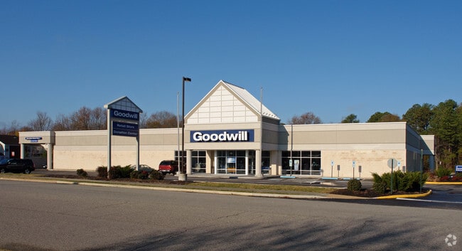
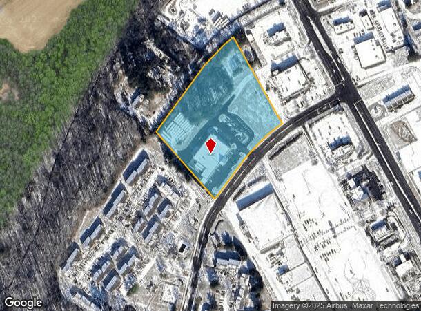
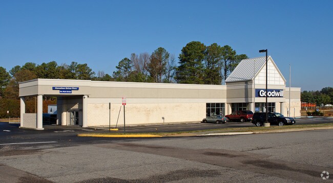
Property Record
65 Crater Cir, Petersburg, VA 23805
NEARBY LISTINGS FOR SALE OR LEASE
Property Detail
65 Crater Cir
088-01-0801
Crater Road Acreage (Not Platted)
Storebuilding
PARCEL C
X
Petersburg
51149C0175C
Virginia
2023
4.36 AC
2025
Petersburg
811100
Richmond VA
15,750 SF
Richmond, VA
DEMOGRAPHICS near 65 Crater Cir
1 Mile
3 Mile
5 Mile
2024 Total Population
3,130
19,175
59,030
2029 Population
3,017
18,769
59,352
Pop Growth 2024-2029
(3.61%)
(2.12%)
+ 0.55%
Average Age
41
42
37
2024 Total Households
1,448
8,455
21,699
HH Growth 2024-2029
(3.80%)
(2.22%)
+ 0.22%
Median Household Inc
$53,257
$54,631
$51,768
Avg Household Size
2.00
2.20
2.30
2024 Avg HH Vehicles
2.00
2.00
2.00
Median Home Value
$155,030
$162,162
$155,604
Median Year Built
1981
1974
1972
Nearby Places
Map Layers
Map Styles
 Street
 Aerial
- Restaurants
- Banks
- Shops
- Fitness
- Groceries
PUBLIC TRANSPORTATION
COMMUTER RAIL
Petersburg Amtrak Station (Carolinian - Amtrak, Northeast Regional - Amtrak, Palmetto - Amtrak, Silver Meteor - Amtrak, Silver Star - Amtrak)
DRIVE
WALK
Distance
Petersburg Amtrak Station (Carolinian - Amtrak, Northeast Regional - Amtrak, Palmetto - Amtrak, Silver Meteor - Amtrak, Silver Star - Amtrak)
11 min
6.4 mi
AIRPORT
Richmond International
DRIVE
WALK
Distance
Richmond International
42 min
31.3 mi
Freight Ports
Virginia Port Authority - Richmond
DRIVE
WALK
Distance
Virginia Port Authority - Richmond
33 min
22.7 mi
Nearby Properties
Address
Land Use
TOTAL SIZE
Lot Size
Zoning
Address
Land Use
TOTAL SIZE
Lot Size
Zoning
24.02 AC
B-2C
Address
Land Use
TOTAL SIZE
Lot Size
Zoning
67,456 SF
512.10 AC
A2
Address
Land Use
TOTAL SIZE
Lot Size
Zoning
28.17 AC
PUD
Address
Land Use
TOTAL SIZE
Lot Size
Zoning
220.52 AC
R1
Address
Land Use
TOTAL SIZE
Lot Size
Zoning
359,504 SF
32.59 AC
R-4
Address
Land Use
TOTAL SIZE
Lot Size
Zoning
17.09 AC
PUD
Address
Land Use
TOTAL SIZE
Lot Size
Zoning
264,335 SF
70 AC
M-2
Address
Land Use
TOTAL SIZE
Lot Size
Zoning
11.57 AC
PUD
Address
Land Use
TOTAL SIZE
Lot Size
Zoning
205,626 SF
151.04 AC
M-2
Address
Land Use
TOTAL SIZE
Lot Size
Zoning
407,650 SF
136.67 AC
M-2
Address
Land Use
TOTAL SIZE
Lot Size
Zoning
185,483 SF
20.98 AC
R-4
Address
Land Use
TOTAL SIZE
Lot Size
Zoning
65,214 SF
8.46 AC
R-4
Address
Land Use
TOTAL SIZE
Lot Size
Zoning
42,561 SF
6.91 AC
B-2C
Address
Land Use
TOTAL SIZE
Lot Size
Zoning
151,980 SF
23.12 AC
PUD
Address
Land Use
TOTAL SIZE
Lot Size
Zoning
149,472 SF
14.68 AC
R-4
Address
Land Use
TOTAL SIZE
Lot Size
Zoning
8.72 AC
PUD
Address
Land Use
TOTAL SIZE
Lot Size
Zoning
1.09 AC
PUD
Address
Land Use
TOTAL SIZE
Lot Size
Zoning
182,760 SF
10.50 AC
R-4
Address
Land Use
TOTAL SIZE
Lot Size
Zoning
102,424 SF
14.71 AC
PUD
Address
Land Use
TOTAL SIZE
Lot Size
Zoning
84,064 SF
15.54 AC
PUD
Address
Land Use
TOTAL SIZE
Lot Size
Zoning
149,228 SF
25.06 AC
M-2
Address
Land Use
TOTAL SIZE
Lot Size
Zoning
33,360 SF
0.45 AC
B-2C
Address
Land Use
TOTAL SIZE
Lot Size
Zoning
68,713 SF
2.33 AC
11
Address
Land Use
TOTAL SIZE
Lot Size
Zoning
101,722 SF
33.23 AC
M-2
Address
Land Use
TOTAL SIZE
Lot Size
Zoning
960 SF
13.24 AC
B-1
Address
Land Use
TOTAL SIZE
Lot Size
Zoning
141,182 SF
7.62 AC
R-4
Address
Land Use
TOTAL SIZE
Lot Size
Zoning
180,000 SF
41.92 AC
M-1
Address
Land Use
TOTAL SIZE
Lot Size
Zoning
58,986 SF
3.83 AC
11
Address
Land Use
TOTAL SIZE
Lot Size
Zoning
44,311 SF
9.05 AC
R-1
Address
Land Use
TOTAL SIZE
Lot Size
Zoning
56,091 SF
3.93 AC
R-2
The World's #1 Commercial Real Estate Marketplace
Connect with us
© 2026 CoStar Group
The information above has been obtained from sources believed reliable. While we do not doubt its accuracy we have not verified it and make no guarantee, warranty or representation about it. It is your responsibility to independently confirm its accuracy and completeness. Any projections, opinions, assumptions, or estimates used are for example only and do not represent the current or future performance of the property. The value of this transaction to you depends on tax and other factors which should be evaluated by your tax, financial, and legal advisors. You and your advisors should conduct a careful, independent investigation of the property to determine to your satisfaction the suitability of the property for your needs.