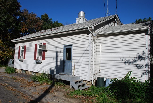
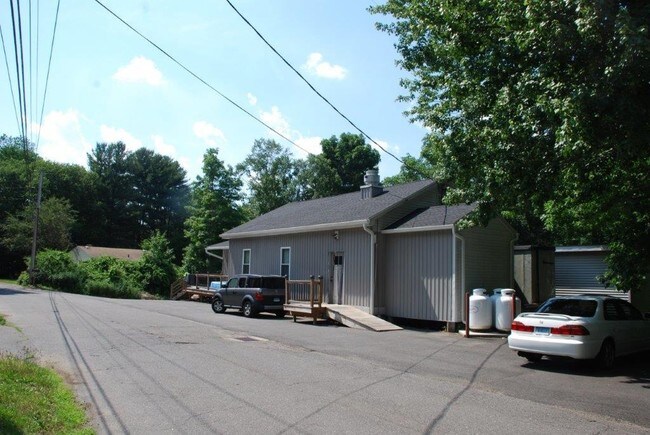
Property Record
65 Garthwait Rd, Wolcott, CT 06716

Property Detail
65 Garthwait Rd
WOLC-000109-000006-000079E
NEW HAVEN
Industrialgeneral
Connecticut
R-40
79e
B and X Area of moderate flood hazard, usually the area between the limits of the 100-year and 500-year floods.
1 AC
2025
Waterbury
2025
Westchester/So Connecticut
361100
New Haven, CT
2,323 SF
NEARBY LISTINGS FOR SALE OR LEASE
DEMOGRAPHICS near 65 Garthwait Rd
1 mile
3 mile
5 mile
2025 Total Population
5,731
76,564
152,629
2030 Population
5,879
78,163
156,135
Pop Growth 2025-2030
+ 2.58%
+ 2.09%
+ 2.30%
Average Age
41
39
39
2025 Total Households
2,371
29,960
58,929
HH Growth 2025-2030
+ 2.57%
+ 2.17%
+ 2.33%
Median Household Inc
$61,453
$51,676
$63,090
Avg Household Size
2.40
2.50
2.50
2025 Avg HH Vehicles
2.00
1.00
2.00
Median Home Value
$293,960
$239,054
$262,904
Median Year Built
1971
1960
1962
Nearby Places
Map Layers
Map Styles
 Street
 Aerial
Transit
 Traffic
 Biking
Places
Listings with unknown addresses are not visible on the map
- Restaurants
- Banks
- Shops
- Fitness
- Groceries
PUBLIC TRANSPORTATION
COMMUTER RAIL
Waterbury Station (New Haven Line - Metro-North Commuter Railroad Company (Metro-North))
Drive
Walk
Distance
Waterbury Station (New Haven Line - Metro-North Commuter Railroad Company (Metro-North))
9 min
4.5 mi
Naugatuck Station (New Haven Line - Metro-North Commuter Railroad Company (Metro-North))
Drive
Walk
Distance
Naugatuck Station (New Haven Line - Metro-North Commuter Railroad Company (Metro-North))
13 min
8.0 mi
AIRPORT
Tweed/New Haven
Drive
Walk
Distance
Tweed/New Haven
46 min
28.7 mi
Bradley International
Drive
Walk
Distance
Bradley International
70 min
39.9 mi
Freight Ports
Port of New Haven
Drive
Walk
Distance
Port of New Haven
41 min
26.4 mi
SALE & LEASE HISTORY
LISTING DATE
SALE/LEASE

Sep 24, 2016
For Sale
Nearby Properties
Address
Land Use
TOTAL SIZE
Lot Size
Zoning
Address
Land Use
TOTAL SIZE
Lot Size
Zoning
77.50 AC
RS
Address
Land Use
TOTAL SIZE
Lot Size
Zoning
306,366 SF
84 AC
RS-12
Address
Land Use
TOTAL SIZE
Lot Size
Zoning
195,000 SF
1.41 AC
CBD
Address
Land Use
TOTAL SIZE
Lot Size
Zoning
97,695 SF
0.57 AC
CBD
Address
Land Use
TOTAL SIZE
Lot Size
Zoning
118,884 SF
13.40 AC
RL
Address
Land Use
TOTAL SIZE
Lot Size
Zoning
103,254 SF
2.03 AC
CBD
Address
Land Use
TOTAL SIZE
Lot Size
Zoning
97,386 SF
53.20 AC
RS
Address
Land Use
TOTAL SIZE
Lot Size
Zoning
44.31 AC
CA
Address
Land Use
TOTAL SIZE
Lot Size
Zoning
45,605 SF
2.48 AC
RH
Address
Land Use
TOTAL SIZE
Lot Size
Zoning
95,000 SF
9.30 AC
RM
Address
Land Use
TOTAL SIZE
Lot Size
Zoning
5.13 AC
RM
Address
Land Use
TOTAL SIZE
Lot Size
Zoning
39 AC
RM
Address
Land Use
TOTAL SIZE
Lot Size
Zoning
19.24 AC
CA
Address
Land Use
TOTAL SIZE
Lot Size
Zoning
35,860 SF
1.29 AC
CBD
Address
Land Use
TOTAL SIZE
Lot Size
Zoning
50 AC
R-40
Address
Land Use
TOTAL SIZE
Lot Size
Zoning
24.49 AC
CA
Address
Land Use
TOTAL SIZE
Lot Size
Zoning
12.49 AC
CA
Address
Land Use
TOTAL SIZE
Lot Size
Zoning
31.75 AC
CA
Address
Land Use
TOTAL SIZE
Lot Size
Zoning
18.01 AC
CA
Address
Land Use
TOTAL SIZE
Lot Size
Zoning
10.51 AC
RL
Address
Land Use
TOTAL SIZE
Lot Size
Zoning
91,324 SF
22.27 AC
RM
Address
Land Use
TOTAL SIZE
Lot Size
Zoning
25,474 SF
20.35 AC
RM
Address
Land Use
TOTAL SIZE
Lot Size
Zoning
25,844 SF
22.20 AC
R-80
Address
Land Use
TOTAL SIZE
Lot Size
Zoning
15.39 AC
RM
Address
Land Use
TOTAL SIZE
Lot Size
Zoning
1.30 AC
CBD
Address
Land Use
TOTAL SIZE
Lot Size
Zoning
152,704 SF
17.09 AC
CA
Address
Land Use
TOTAL SIZE
Lot Size
Zoning
121,204 SF
0.43 AC
CBD
Address
Land Use
TOTAL SIZE
Lot Size
Zoning
1.02 AC
CBD
Address
Land Use
TOTAL SIZE
Lot Size
Zoning
81,501 SF
19 AC
R-30
Address
Land Use
TOTAL SIZE
Lot Size
Zoning
5.10 AC
RM
The World's #1 Commercial Real Estate Marketplace
Connect with us
© 2026 CoStar Group
The information above has been obtained from sources believed reliable. While we do not doubt its accuracy we have not verified it and make no guarantee, warranty or representation about it. It is your responsibility to independently confirm its accuracy and completeness. Any projections, opinions, assumptions, or estimates used are for example only and do not represent the current or future performance of the property. The value of this transaction to you depends on tax and other factors which should be evaluated by your tax, financial, and legal advisors. You and your advisors should conduct a careful, independent investigation of the property to determine to your satisfaction the suitability of the property for your needs.