Property Record
65 Main St N, Pearson, GA 31642
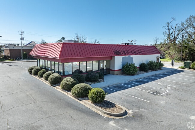

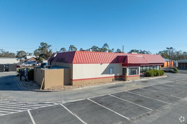
Property Detail
65 Main St N
Douglas, GA
LOT LL 31 7TH HARDEES
P011031
Atkinson
Restaurantdrivein
Georgia
B and X Area of moderate flood hazard, usually the area between the limits of the 100-year and 500-year floods.
ll
2025
0.85 AC
2025
Georgia South Area
960200
Other Market Areas
3,320 SF
NEARBY LISTINGS FOR SALE OR LEASE
-
-
View all Pearson listings for sale on LoopNet.com
DEMOGRAPHICS near 65 Main St N
1 mile
3 mile
5 mile
2025 Total Population
1,611
2,461
3,778
2030 Population
1,596
2,450
3,772
Pop Growth 2025-2030
(0.93%)
(0.45%)
(0.16%)
Average Age
37
37
37
2025 Total Households
577
880
1,350
HH Growth 2025-2030
(1.04%)
(0.57%)
(0.22%)
Median Household Inc
$34,676
$35,469
$37,579
Avg Household Size
2.80
2.80
2.80
2025 Avg HH Vehicles
2.00
2.00
2.00
Median Home Value
$80,720
$83,615
$85,687
Median Year Built
1991
1991
1991
Nearby Places
Map Layers
Map Styles
 Street
 Aerial
Layers
 Traffic
 Biking
Places
Listings with unknown addresses are not visible on the map
- Restaurants
- Banks
- Shops
- Fitness
- Groceries
SALE & LEASE HISTORY
LISTING DATE
SALE/LEASE

Nov 14, 2024
For Sale
Aug 31, 2023
For Lease
Nearby Properties
Address
Land Use
TOTAL SIZE
Lot Size
Zoning
Address
Land Use
TOTAL SIZE
Lot Size
Zoning
105.04 AC
Address
Land Use
TOTAL SIZE
Lot Size
Zoning
Address
Land Use
TOTAL SIZE
Lot Size
Zoning
7,296 SF
8.89 AC
Address
Land Use
TOTAL SIZE
Lot Size
Zoning
58,870 SF
15.36 AC
Address
Land Use
TOTAL SIZE
Lot Size
Zoning
784 SF
12.47 AC
Address
Land Use
TOTAL SIZE
Lot Size
Zoning
4,212 SF
2.30 AC
Address
Land Use
TOTAL SIZE
Lot Size
Zoning
7,452 SF
16.33 AC
Address
Land Use
TOTAL SIZE
Lot Size
Zoning
400 SF
2.98 AC
Address
Land Use
TOTAL SIZE
Lot Size
Zoning
10,080 SF
3.08 AC
Address
Land Use
TOTAL SIZE
Lot Size
Zoning
1,680 SF
621 AC
Address
Land Use
TOTAL SIZE
Lot Size
Zoning
2,520 SF
72.10 AC
Address
Land Use
TOTAL SIZE
Lot Size
Zoning
12,000 SF
3.34 AC
Address
Land Use
TOTAL SIZE
Lot Size
Zoning
3,256 SF
1.94 AC
Address
Land Use
TOTAL SIZE
Lot Size
Zoning
Address
Land Use
TOTAL SIZE
Lot Size
Zoning
12,300 SF
1.05 AC
Address
Land Use
TOTAL SIZE
Lot Size
Zoning
1,612 SF
371.03 AC
Address
Land Use
TOTAL SIZE
Lot Size
Zoning
15,763 SF
1.96 AC
Address
Land Use
TOTAL SIZE
Lot Size
Zoning
33,600 SF
4 AC
Address
Land Use
TOTAL SIZE
Lot Size
Zoning
15,360 SF
0.72 AC
Address
Land Use
TOTAL SIZE
Lot Size
Zoning
16,240 SF
4.22 AC
Address
Land Use
TOTAL SIZE
Lot Size
Zoning
Address
Land Use
TOTAL SIZE
Lot Size
Zoning
12,628 SF
1.65 AC
Address
Land Use
TOTAL SIZE
Lot Size
Zoning
82.64 AC
Address
Land Use
TOTAL SIZE
Lot Size
Zoning
5,254 SF
0.29 AC
Address
Land Use
TOTAL SIZE
Lot Size
Zoning
4,142 SF
1 AC
Address
Land Use
TOTAL SIZE
Lot Size
Zoning
104,025 SF
7.94 AC
Address
Land Use
TOTAL SIZE
Lot Size
Zoning
3,200 SF
0.51 AC
The World's #1 Commercial Real Estate Marketplace
Connect with us
© 2026 CoStar Group
The information above has been obtained from sources believed reliable. While we do not doubt its accuracy we have not verified it and make no guarantee, warranty or representation about it. It is your responsibility to independently confirm its accuracy and completeness. Any projections, opinions, assumptions, or estimates used are for example only and do not represent the current or future performance of the property. The value of this transaction to you depends on tax and other factors which should be evaluated by your tax, financial, and legal advisors. You and your advisors should conduct a careful, independent investigation of the property to determine to your satisfaction the suitability of the property for your needs.