Property Record
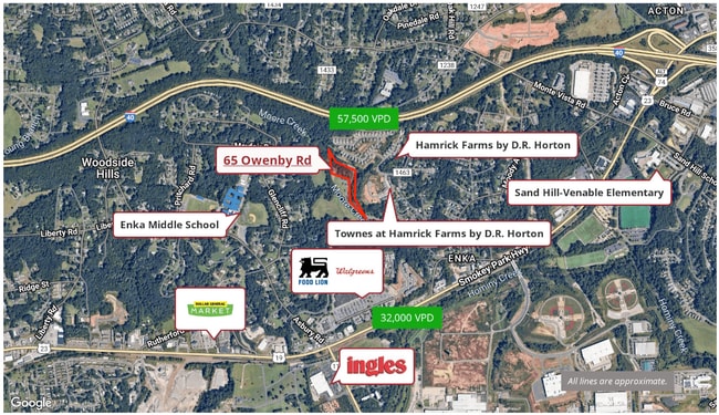
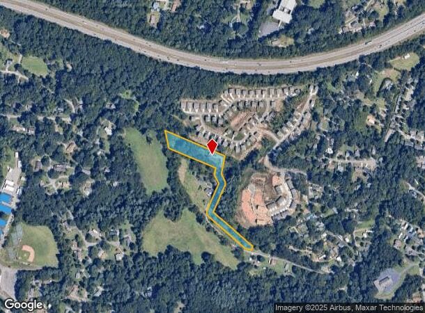
65 Owenby Rd, Asheville, NC 28804
This Property Is For Sale
NEARBY LISTINGS FOR SALE OR LEASE
Property Detail
65 Owenby Rd
Asheville
Buncombe
Asheville, NC
North Carolina
9617-26-1700-00000
3.02 AC
Sfr
West Asheville
1,500 SF
DEMOGRAPHICS near 65 Owenby Rd
1 Mile
3 Mile
5 Mile
2024 Total Population
3,838
27,778
64,379
2029 Population
4,132
29,812
68,931
Pop Growth 2024-2029
+ 7.66%
+ 7.32%
+ 7.07%
Average Age
43
42
41
2024 Total Households
1,562
11,564
27,035
HH Growth 2024-2029
+ 6.98%
+ 6.59%
+ 6.33%
Median Household Inc
$83,911
$70,502
$67,227
Avg Household Size
2.40
2.30
2.30
2024 Avg HH Vehicles
2.00
2.00
2.00
Median Home Value
$417,208
$401,885
$383,297
Median Year Built
1990
1989
1986
Nearby Places
- Restaurants
- Banks
- Shops
- Fitness
- Groceries
PUBLIC TRANSPORTATION
AIRPORT
Asheville Regional
DRIVE
WALK
Distance
Asheville Regional
19 min
12.8 mi
Freight Ports
North Charleston Terminal
DRIVE
WALK
Distance
North Charleston Terminal
291 min
256.6 mi
Nearby Properties
Address
Land Use
TOTAL SIZE
Lot Size
Zoning
Address
Land Use
TOTAL SIZE
Lot Size
Zoning
251,071 SF
280.42 AC
INST
Address
Land Use
TOTAL SIZE
Lot Size
Zoning
98,232 SF
23.24 AC
EMP
Address
Land Use
TOTAL SIZE
Lot Size
Zoning
104,138 SF
33.25 AC
R-2
Address
Land Use
TOTAL SIZE
Lot Size
Zoning
85,997 SF
29.25 AC
R-3
Address
Land Use
TOTAL SIZE
Lot Size
Zoning
50,672 SF
21.21 AC
R-2
Address
Land Use
TOTAL SIZE
Lot Size
Zoning
88,817 SF
19.63 AC
R-2
Address
Land Use
TOTAL SIZE
Lot Size
Zoning
134,180 SF
60.94 AC
PS
Address
Land Use
TOTAL SIZE
Lot Size
Zoning
151,884 SF
129.72 AC
PS
Address
Land Use
TOTAL SIZE
Lot Size
Zoning
111,000 SF
21.97 AC
PS
Address
Land Use
TOTAL SIZE
Lot Size
Zoning
94,565 SF
25.18 AC
EMP
Address
Land Use
TOTAL SIZE
Lot Size
Zoning
126,508 SF
14.90 AC
EMP
Address
Land Use
TOTAL SIZE
Lot Size
Zoning
52,316 SF
13.68 AC
INST
Address
Land Use
TOTAL SIZE
Lot Size
Zoning
145,519 SF
10.75 AC
R-2
Address
Land Use
TOTAL SIZE
Lot Size
Zoning
79,908 SF
60 AC
PS
Address
Land Use
TOTAL SIZE
Lot Size
Zoning
131,946 SF
13.28 AC
EMP
Address
Land Use
TOTAL SIZE
Lot Size
Zoning
35,952 SF
9.30 AC
RM16
Address
Land Use
TOTAL SIZE
Lot Size
Zoning
145,468 SF
24.91 AC
COM EXP
Address
Land Use
TOTAL SIZE
Lot Size
Zoning
75,988 SF
12.90 AC
PS
Address
Land Use
TOTAL SIZE
Lot Size
Zoning
141,577 SF
30.05 AC
Address
Land Use
TOTAL SIZE
Lot Size
Zoning
70,824 SF
12 AC
INST
Address
Land Use
TOTAL SIZE
Lot Size
Zoning
39,368 SF
7.77 AC
R-2
Address
Land Use
TOTAL SIZE
Lot Size
Zoning
196,498 SF
14.61 AC
EMP
Address
Land Use
TOTAL SIZE
Lot Size
Zoning
72,426 SF
11.87 AC
RM16
Address
Land Use
TOTAL SIZE
Lot Size
Zoning
88,306 SF
10.29 AC
CS
Address
Land Use
TOTAL SIZE
Lot Size
Zoning
43,285 SF
7.88 AC
R-2
Address
Land Use
TOTAL SIZE
Lot Size
Zoning
94,560 SF
13.52 AC
PS
Address
Land Use
TOTAL SIZE
Lot Size
Zoning
126,826 SF
19.01 AC
HB
Address
Land Use
TOTAL SIZE
Lot Size
Zoning
82,535 SF
13.69 AC
HB
Address
Land Use
TOTAL SIZE
Lot Size
Zoning
4,492 SF
44.52 AC
PS
Address
Land Use
TOTAL SIZE
Lot Size
Zoning
56,400 SF
7.46 AC
OU
The World's #1 Commercial Real Estate Marketplace
Connect with us
© 2025 CoStar Group
The information above has been obtained from sources believed reliable. While we do not doubt its accuracy we have not verified it and make no guarantee, warranty or representation about it. It is your responsibility to independently confirm its accuracy and completeness. Any projections, opinions, assumptions, or estimates used are for example only and do not represent the current or future performance of the property. The value of this transaction to you depends on tax and other factors which should be evaluated by your tax, financial, and legal advisors. You and your advisors should conduct a careful, independent investigation of the property to determine to your satisfaction the suitability of the property for your needs.