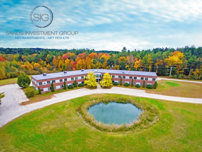
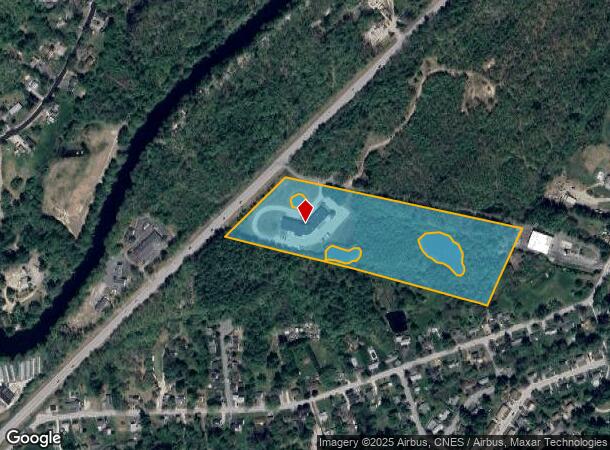
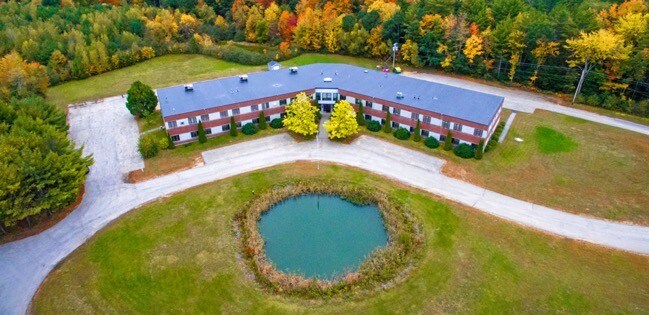
Property Record
65 Pinewood Rd, Allenstown, NH 03275
NEARBY LISTINGS FOR SALE OR LEASE
Property Detail
65 Pinewood Rd
ALLE-000105-000000-000004
Merrimack
Commercialbuilding
New Hampshire
X
4
33013C0568E
14.50 AC
2024
Concord/New Hampshire North Area
2024
Other Market Areas
003100
Concord, NH
32,689 SF
DEMOGRAPHICS near 65 Pinewood Rd
1 Mile
3 Mile
5 Mile
2024 Total Population
3,931
12,310
23,302
2029 Population
4,146
13,027
24,672
Pop Growth 2024-2029
+ 5.47%
+ 5.82%
+ 5.88%
Average Age
41
41
42
2024 Total Households
1,686
5,052
9,433
HH Growth 2024-2029
+ 5.34%
+ 5.70%
+ 5.79%
Median Household Inc
$60,597
$76,310
$87,377
Avg Household Size
2.30
2.40
2.40
2024 Avg HH Vehicles
2.00
2.00
2.00
Median Home Value
$226,462
$265,373
$291,686
Median Year Built
1971
1971
1980
Nearby Places
Map Layers
Map Styles
 Street
 Aerial
- Restaurants
- Banks
- Shops
- Fitness
- Groceries
PUBLIC TRANSPORTATION
AIRPORT
Manchester Boston Regional
DRIVE
WALK
Distance
Manchester Boston Regional
37 min
19.3 mi
Portsmouth International at Pease
DRIVE
WALK
Distance
Portsmouth International at Pease
68 min
41.4 mi
SALE & LEASE HISTORY
LISTING DATE
SALE/LEASE

Oct 16, 2018
For Sale
Nearby Properties
Address
Land Use
TOTAL SIZE
Lot Size
Zoning
Address
Land Use
TOTAL SIZE
Lot Size
Zoning
266,056 SF
22.11 AC
I2
Address
Land Use
TOTAL SIZE
Lot Size
Zoning
6,000 SF
66.58 AC
I2
Address
Land Use
TOTAL SIZE
Lot Size
Zoning
147,477 SF
41.81 AC
R-1A
Address
Land Use
TOTAL SIZE
Lot Size
Zoning
91,930 SF
59 AC
IND -
Address
Land Use
TOTAL SIZE
Lot Size
Zoning
114,272 SF
12.86 AC
CLI -
Address
Land Use
TOTAL SIZE
Lot Size
Zoning
183.12 AC
OSF -
Address
Land Use
TOTAL SIZE
Lot Size
Zoning
28,124 SF
17.08 AC
I2
Address
Land Use
TOTAL SIZE
Lot Size
Zoning
16,461 SF
3.49 AC
Address
Land Use
TOTAL SIZE
Lot Size
Zoning
17,842 SF
3.74 AC
Address
Land Use
TOTAL SIZE
Lot Size
Zoning
57,804 SF
2.75 AC
HDR
Address
Land Use
TOTAL SIZE
Lot Size
Zoning
213 SF
75 AC
OSF -
Address
Land Use
TOTAL SIZE
Lot Size
Zoning
10,200 SF
26.88 AC
I2
Address
Land Use
TOTAL SIZE
Lot Size
Zoning
Address
Land Use
TOTAL SIZE
Lot Size
Zoning
70,416 SF
8.50 AC
I2
Address
Land Use
TOTAL SIZE
Lot Size
Zoning
23,466 SF
5.25 AC
Address
Land Use
TOTAL SIZE
Lot Size
Zoning
23,780 SF
5.51 AC
Address
Land Use
TOTAL SIZE
Lot Size
Zoning
211 AC
I2
Address
Land Use
TOTAL SIZE
Lot Size
Zoning
31,989 SF
5.45 AC
R-1A
Address
Land Use
TOTAL SIZE
Lot Size
Zoning
45,252 SF
41 AC
R-1A
Address
Land Use
TOTAL SIZE
Lot Size
Zoning
10,506 SF
12.20 AC
IND -
Address
Land Use
TOTAL SIZE
Lot Size
Zoning
Address
Land Use
TOTAL SIZE
Lot Size
Zoning
5,436 SF
7.85 AC
SB
Address
Land Use
TOTAL SIZE
Lot Size
Zoning
9,720 SF
66.30 AC
IND
Address
Land Use
TOTAL SIZE
Lot Size
Zoning
16,250 SF
1.05 AC
IND -
Address
Land Use
TOTAL SIZE
Lot Size
Zoning
3,005 SF
2.57 AC
B - BU
Address
Land Use
TOTAL SIZE
Lot Size
Zoning
52,424 SF
21.32 AC
I2
Address
Land Use
TOTAL SIZE
Lot Size
Zoning
34,468 SF
2.49 AC
R1 - R
Address
Land Use
TOTAL SIZE
Lot Size
Zoning
192.56 AC
SB
Address
Land Use
TOTAL SIZE
Lot Size
Zoning
3,040 SF
20.10 AC
R-1A
Address
Land Use
TOTAL SIZE
Lot Size
Zoning
50,180 SF
6.80 AC
SB
The World's #1 Commercial Real Estate Marketplace
Connect with us
© 2026 CoStar Group
The information above has been obtained from sources believed reliable. While we do not doubt its accuracy we have not verified it and make no guarantee, warranty or representation about it. It is your responsibility to independently confirm its accuracy and completeness. Any projections, opinions, assumptions, or estimates used are for example only and do not represent the current or future performance of the property. The value of this transaction to you depends on tax and other factors which should be evaluated by your tax, financial, and legal advisors. You and your advisors should conduct a careful, independent investigation of the property to determine to your satisfaction the suitability of the property for your needs.