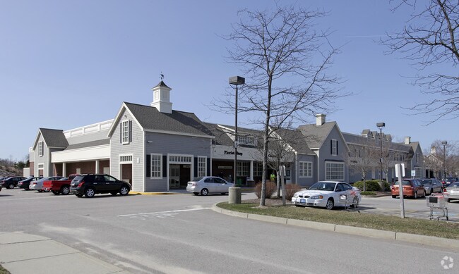
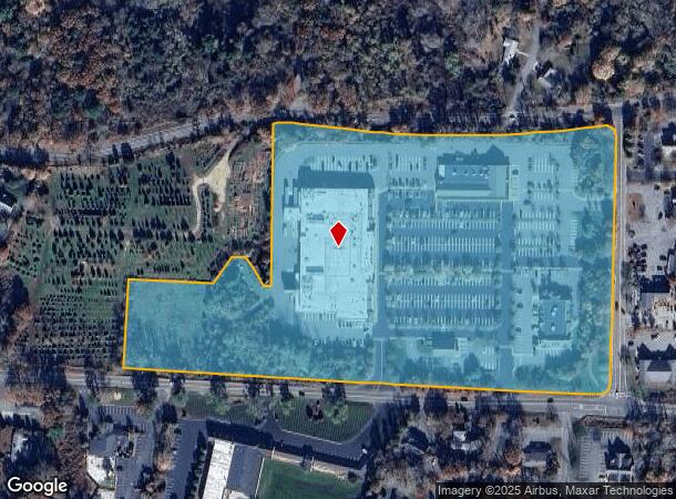
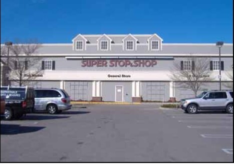
Property Record
65 Route 6A, Sandwich, MA 02563
NEARBY LISTINGS FOR SALE OR LEASE
Property Detail
65 Route 6A
Commercialnec
Barnstable
X
Massachusetts
25001C0319J
16.20 AC
2025
Cape Cod
2025
Other Market Areas
013300
Barnstable Town, MA
1,764 SF
SAND-000087-000079
DEMOGRAPHICS near 65 Route 6A
1 Mile
3 Mile
5 Mile
2024 Total Population
1,875
7,415
20,486
2029 Population
1,850
7,292
20,404
Pop Growth 2024-2029
(1.33%)
(1.66%)
(0.40%)
Average Age
53
48
46
2024 Total Households
840
3,094
8,151
HH Growth 2024-2029
(1.67%)
(2.07%)
(0.71%)
Median Household Inc
$92,429
$98,177
$101,899
Avg Household Size
2.10
2.30
2.40
2024 Avg HH Vehicles
2.00
2.00
2.00
Median Home Value
$477,352
$473,738
$453,066
Median Year Built
1969
1977
1981
Nearby Places
Map Layers
Map Styles
 Street
 Aerial
- Restaurants
- Banks
- Shops
- Fitness
- Groceries
PUBLIC TRANSPORTATION
COMMUTER RAIL
Bourne (CapeFLYER - Cape Cod Regional Transit Authority)
DRIVE
WALK
Distance
Bourne (CapeFLYER - Cape Cod Regional Transit Authority)
10 min
5.5 mi
Buzzards Bay (CapeFLYER - Cape Cod Regional Transit Authority)
DRIVE
WALK
Distance
Buzzards Bay (CapeFLYER - Cape Cod Regional Transit Authority)
15 min
8.1 mi
AIRPORT
Martha's Vineyard
DRIVE
WALK
Distance
Martha's Vineyard
97 min
36.2 mi
Freight Ports
Port of New Bedford Harbor
DRIVE
WALK
Distance
Port of New Bedford Harbor
45 min
32.8 mi
Nearby Properties
Address
Land Use
TOTAL SIZE
Lot Size
Zoning
Address
Land Use
TOTAL SIZE
Lot Size
Zoning
654.71 AC
R40
Address
Land Use
TOTAL SIZE
Lot Size
Zoning
Address
Land Use
TOTAL SIZE
Lot Size
Zoning
2,295.68 AC
R-1
Address
Land Use
TOTAL SIZE
Lot Size
Zoning
325 AC
R-1
Address
Land Use
TOTAL SIZE
Lot Size
Zoning
46.68 AC
R-1
Address
Land Use
TOTAL SIZE
Lot Size
Zoning
5,928 SF
12.90 AC
Address
Land Use
TOTAL SIZE
Lot Size
Zoning
148.70 AC
R40
Address
Land Use
TOTAL SIZE
Lot Size
Zoning
Address
Land Use
TOTAL SIZE
Lot Size
Zoning
29.83 AC
IND
Address
Land Use
TOTAL SIZE
Lot Size
Zoning
41.40 AC
IND
Address
Land Use
TOTAL SIZE
Lot Size
Zoning
4.94 AC
VILLAG
Address
Land Use
TOTAL SIZE
Lot Size
Zoning
11.97 AC
MARINE
Address
Land Use
TOTAL SIZE
Lot Size
Zoning
31.50 AC
MARINE
Address
Land Use
TOTAL SIZE
Lot Size
Zoning
83.01 AC
R-2
Address
Land Use
TOTAL SIZE
Lot Size
Zoning
36,388 SF
6.70 AC
BL-1
Address
Land Use
TOTAL SIZE
Lot Size
Zoning
40,476 SF
7 AC
BL-1
Address
Land Use
TOTAL SIZE
Lot Size
Zoning
17,110 SF
1.68 AC
R-1
Address
Land Use
TOTAL SIZE
Lot Size
Zoning
39,202 SF
6.31 AC
BL-1
Address
Land Use
TOTAL SIZE
Lot Size
Zoning
610 SF
24.11 AC
R-1
Address
Land Use
TOTAL SIZE
Lot Size
Zoning
21.30 AC
IND
Address
Land Use
TOTAL SIZE
Lot Size
Zoning
4,146 SF
11.40 AC
BL-1
Address
Land Use
TOTAL SIZE
Lot Size
Zoning
8,989 SF
1.19 AC
MARINE
Address
Land Use
TOTAL SIZE
Lot Size
Zoning
Address
Land Use
TOTAL SIZE
Lot Size
Zoning
95.35 AC
RIDGE
Address
Land Use
TOTAL SIZE
Lot Size
Zoning
16,449 SF
4.21 AC
Address
Land Use
TOTAL SIZE
Lot Size
Zoning
10,691 SF
0.75 AC
VILLAG
Address
Land Use
TOTAL SIZE
Lot Size
Zoning
15,740 SF
4.30 AC
R-1
Address
Land Use
TOTAL SIZE
Lot Size
Zoning
12,480 SF
1 AC
BL-1
Address
Land Use
TOTAL SIZE
Lot Size
Zoning
3 AC
BUSINE
The World's #1 Commercial Real Estate Marketplace
Connect with us
© 2026 CoStar Group
The information above has been obtained from sources believed reliable. While we do not doubt its accuracy we have not verified it and make no guarantee, warranty or representation about it. It is your responsibility to independently confirm its accuracy and completeness. Any projections, opinions, assumptions, or estimates used are for example only and do not represent the current or future performance of the property. The value of this transaction to you depends on tax and other factors which should be evaluated by your tax, financial, and legal advisors. You and your advisors should conduct a careful, independent investigation of the property to determine to your satisfaction the suitability of the property for your needs.