Property Record
66Th South Dr, Belleville, IL 62226
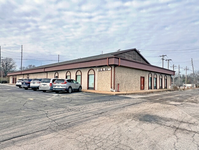

This Property Is For Sale
NEARBY LISTINGS FOR SALE OR LEASE
Property Detail
66Th South Dr
St. Louis
Belleville
St. Louis, MO-IL
BELLEVILLE TWP SECTION 11 12 13 14 & 15 LOT/SEC-12-SUBL/TWP-1N-BLK/RG-9W PT FORMER ROW DOC A01908931
07-12.0-201-029
St. Clair
Residentialacreage
Illinois
2024
0.31 AC
2024
Illinois
503301
DEMOGRAPHICS near 66Th South Dr
1 mile
3 mile
5 mile
2024 Total Population
6,906
35,612
87,668
2029 Population
6,677
34,476
85,428
Pop Growth 2024-2029
(3.32%)
(3.19%)
(2.56%)
Average Age
43
42
42
2024 Total Households
3,013
15,628
37,329
HH Growth 2024-2029
(3.29%)
(3.19%)
(2.57%)
Median Household Inc
$73,060
$63,743
$63,553
Avg Household Size
2.20
2.20
2.30
2024 Avg HH Vehicles
2.00
2.00
2.00
Median Home Value
$154,627
$144,225
$135,984
Median Year Built
1963
1964
1967
Nearby Places
Map Layers
Map Styles
 Street
 Aerial
Transit
 Traffic
 Biking
Places
Listings with unknown addresses are not visible on the map
- Restaurants
- Banks
- Shops
- Fitness
- Groceries
PUBLIC TRANSPORTATION
COMMUTER RAIL
Memorial Hospital (Lambert Airport Shiloh-Scott - St. Louis MetroLink (MetroLink))
Drive
Walk
Distance
Memorial Hospital (Lambert Airport Shiloh-Scott - St. Louis MetroLink (MetroLink))
3 min
1.8 mi
Fairview Heights (Lambert Airport Shiloh-Scott - St. Louis MetroLink (MetroLink), Shrewsbury-Lansdowne I-44 Emerson Park - St. Louis MetroLink (MetroLink))
Drive
Walk
Distance
Fairview Heights (Lambert Airport Shiloh-Scott - St. Louis MetroLink (MetroLink), Shrewsbury-Lansdowne I-44 Emerson Park - St. Louis MetroLink (MetroLink))
9 min
4.3 mi
AIRPORT
Scott AFB/Midamerica St Louis
Drive
Walk
Distance
Scott AFB/Midamerica St Louis
29 min
15.1 mi
St Louis Lambert International
Drive
Walk
Distance
St Louis Lambert International
39 min
24.4 mi
Freight Ports
Port Milwaukee
Drive
Walk
Distance
Port Milwaukee
419 min
368.0 mi
Nearby Properties
Address
Land Use
TOTAL SIZE
Lot Size
Zoning
Address
Land Use
TOTAL SIZE
Lot Size
Zoning
Address
Land Use
TOTAL SIZE
Lot Size
Zoning
127,590 SF
10.53 AC
Address
Land Use
TOTAL SIZE
Lot Size
Zoning
18,734 SF
10.48 AC
Address
Land Use
TOTAL SIZE
Lot Size
Zoning
104,230 SF
11.08 AC
Address
Land Use
TOTAL SIZE
Lot Size
Zoning
147,888 SF
52.30 AC
Address
Land Use
TOTAL SIZE
Lot Size
Zoning
Address
Land Use
TOTAL SIZE
Lot Size
Zoning
82,500 SF
14.61 AC
Address
Land Use
TOTAL SIZE
Lot Size
Zoning
49,248 SF
2 AC
Address
Land Use
TOTAL SIZE
Lot Size
Zoning
10,505 SF
20.08 AC
Address
Land Use
TOTAL SIZE
Lot Size
Zoning
6,800 SF
4.33 AC
Address
Land Use
TOTAL SIZE
Lot Size
Zoning
130,254 SF
11.44 AC
Address
Land Use
TOTAL SIZE
Lot Size
Zoning
13,546 SF
11.19 AC
Address
Land Use
TOTAL SIZE
Lot Size
Zoning
4,420 SF
3.82 AC
Address
Land Use
TOTAL SIZE
Lot Size
Zoning
15,839 SF
5.96 AC
Address
Land Use
TOTAL SIZE
Lot Size
Zoning
90,945 SF
5.93 AC
Address
Land Use
TOTAL SIZE
Lot Size
Zoning
16,549 SF
5.44 AC
Address
Land Use
TOTAL SIZE
Lot Size
Zoning
54,179 SF
9.26 AC
Address
Land Use
TOTAL SIZE
Lot Size
Zoning
18.43 AC
Address
Land Use
TOTAL SIZE
Lot Size
Zoning
26.26 AC
C2
Address
Land Use
TOTAL SIZE
Lot Size
Zoning
18,837 SF
134.15 AC
Address
Land Use
TOTAL SIZE
Lot Size
Zoning
4.70 AC
Address
Land Use
TOTAL SIZE
Lot Size
Zoning
15,480 SF
1.35 AC
Address
Land Use
TOTAL SIZE
Lot Size
Zoning
52,232 SF
4.06 AC
Address
Land Use
TOTAL SIZE
Lot Size
Zoning
51,739 SF
1.99 AC
Address
Land Use
TOTAL SIZE
Lot Size
Zoning
30,779 SF
3.26 AC
Address
Land Use
TOTAL SIZE
Lot Size
Zoning
14,748 SF
1.78 AC
Address
Land Use
TOTAL SIZE
Lot Size
Zoning
6.65 AC
Address
Land Use
TOTAL SIZE
Lot Size
Zoning
68,968 SF
3.55 AC
Address
Land Use
TOTAL SIZE
Lot Size
Zoning
5,512 SF
10.36 AC
Address
Land Use
TOTAL SIZE
Lot Size
Zoning
102,418 SF
9.70 AC
The World's #1 Commercial Real Estate Marketplace
Connect with us
© 2026 CoStar Group
The information above has been obtained from sources believed reliable. While we do not doubt its accuracy we have not verified it and make no guarantee, warranty or representation about it. It is your responsibility to independently confirm its accuracy and completeness. Any projections, opinions, assumptions, or estimates used are for example only and do not represent the current or future performance of the property. The value of this transaction to you depends on tax and other factors which should be evaluated by your tax, financial, and legal advisors. You and your advisors should conduct a careful, independent investigation of the property to determine to your satisfaction the suitability of the property for your needs.