Property Record
650 Highway 67 S, Decatur, AL 35603


NEARBY LISTINGS FOR SALE OR LEASE
-
-
View all Decatur listings for sale on LoopNet.com
Property Detail
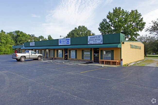
650 Highway 67 S
Decatur, AL
Priceville S/D
11-04-18-0-007-002.001
PRT OF TRACT 1, BLOCK A, E PRICEVILLE S/D, COM AT NW COR OF THE NE1/4 OF SW1/4 SEC 18, T6S, R3W, TH E 526.8' TO NW COR OF LOT
Storebuilding
Morgan
X
Alabama
01103C0095F
3
2025
1.20 AC
2024
Alabama North Area
005404
Other Market Areas
7,744 SF
DEMOGRAPHICS near 650 Highway 67 S
1 Mile
3 Mile
5 Mile
2024 Total Population
1,818
8,251
14,593
2029 Population
1,823
8,324
14,741
Pop Growth 2024-2029
+ 0.28%
+ 0.88%
+ 1.01%
Average Age
41
43
42
2024 Total Households
680
3,193
5,680
HH Growth 2024-2029
+ 0.29%
+ 0.85%
+ 1.00%
Median Household Inc
$80,208
$86,359
$81,510
Avg Household Size
2.60
2.60
2.50
2024 Avg HH Vehicles
2.00
2.00
2.00
Median Home Value
$210,764
$255,950
$233,879
Median Year Built
2001
1997
1993
Nearby Places
Map Layers
Map Styles
 Street
 Aerial
- Restaurants
- Banks
- Shops
- Fitness
- Groceries
PUBLIC TRANSPORTATION
AIRPORT
Huntsville International-Carl T Jones Field
DRIVE
WALK
Distance
Huntsville International-Carl T Jones Field
26 min
18.3 mi
Nearby Properties
Address
Land Use
TOTAL SIZE
Lot Size
Zoning
Address
Land Use
TOTAL SIZE
Lot Size
Zoning
42,616 SF
19 AC
Address
Land Use
TOTAL SIZE
Lot Size
Zoning
31,720 SF
6 AC
Address
Land Use
TOTAL SIZE
Lot Size
Zoning
13,509 SF
6.94 AC
Address
Land Use
TOTAL SIZE
Lot Size
Zoning
22,632 SF
2 AC
Address
Land Use
TOTAL SIZE
Lot Size
Zoning
28,590 SF
3.40 AC
Address
Land Use
TOTAL SIZE
Lot Size
Zoning
5,066 SF
3.80 AC
Address
Land Use
TOTAL SIZE
Lot Size
Zoning
32,006 SF
1.43 AC
Address
Land Use
TOTAL SIZE
Lot Size
Zoning
21,220 SF
3.50 AC
Address
Land Use
TOTAL SIZE
Lot Size
Zoning
5,000 SF
157 AC
Address
Land Use
TOTAL SIZE
Lot Size
Zoning
23,932 SF
1.40 AC
Address
Land Use
TOTAL SIZE
Lot Size
Zoning
14,700 SF
4.40 AC
Address
Land Use
TOTAL SIZE
Lot Size
Zoning
3,939 SF
1.30 AC
Address
Land Use
TOTAL SIZE
Lot Size
Zoning
6,400 SF
15 AC
Address
Land Use
TOTAL SIZE
Lot Size
Zoning
10,250 SF
4.70 AC
Address
Land Use
TOTAL SIZE
Lot Size
Zoning
13,804 SF
12 AC
Address
Land Use
TOTAL SIZE
Lot Size
Zoning
9,140 SF
5 AC
Address
Land Use
TOTAL SIZE
Lot Size
Zoning
9,900 SF
2.50 AC
Address
Land Use
TOTAL SIZE
Lot Size
Zoning
1,625 SF
2.70 AC
Address
Land Use
TOTAL SIZE
Lot Size
Zoning
10,998 SF
1.50 AC
Address
Land Use
TOTAL SIZE
Lot Size
Zoning
5,263 SF
25 AC
Address
Land Use
TOTAL SIZE
Lot Size
Zoning
4,640 SF
2.20 AC
Address
Land Use
TOTAL SIZE
Lot Size
Zoning
12,000 SF
6.80 AC
Address
Land Use
TOTAL SIZE
Lot Size
Zoning
3,360 SF
0.40 AC
Address
Land Use
TOTAL SIZE
Lot Size
Zoning
9,350 SF
1.90 AC
Address
Land Use
TOTAL SIZE
Lot Size
Zoning
2,352 SF
0.70 AC
Address
Land Use
TOTAL SIZE
Lot Size
Zoning
18,975 SF
47 AC
Address
Land Use
TOTAL SIZE
Lot Size
Zoning
9,100 SF
3.50 AC
Address
Land Use
TOTAL SIZE
Lot Size
Zoning
6,054 SF
6 AC
Address
Land Use
TOTAL SIZE
Lot Size
Zoning
12,690 SF
4.60 AC
The World's #1 Commercial Real Estate Marketplace
Connect with us
© 2025 CoStar Group
The information above has been obtained from sources believed reliable. While we do not doubt its accuracy we have not verified it and make no guarantee, warranty or representation about it. It is your responsibility to independently confirm its accuracy and completeness. Any projections, opinions, assumptions, or estimates used are for example only and do not represent the current or future performance of the property. The value of this transaction to you depends on tax and other factors which should be evaluated by your tax, financial, and legal advisors. You and your advisors should conduct a careful, independent investigation of the property to determine to your satisfaction the suitability of the property for your needs.