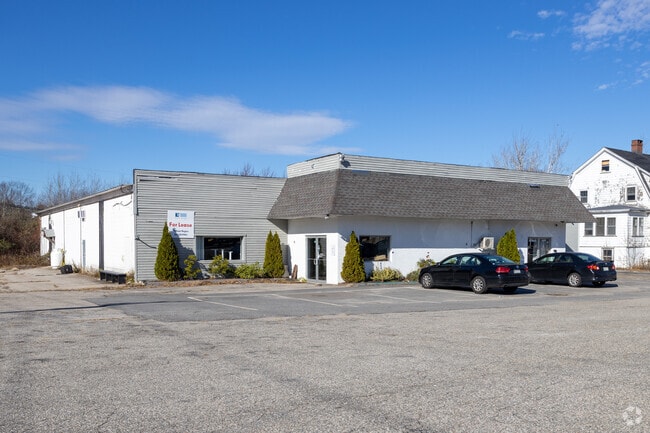
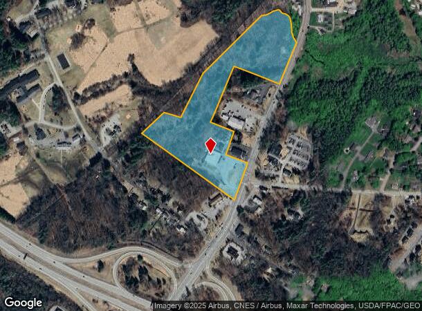
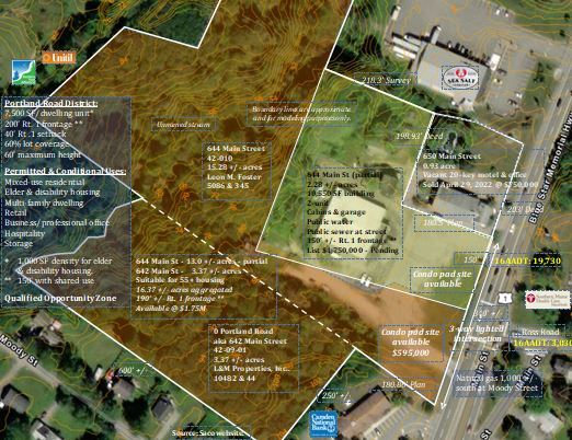
Property Record
644 Main St, Saco, ME 04072
NEARBY LISTINGS FOR SALE OR LEASE
Property Detail
644 Main St
SACO-000042-000010
York
Commercialofficeresidentialmixeduse
Maine
A
10
23031C0318G
15.28 AC
2024
York County
2024
Portland/South Portland
005200
Portland-South Portland, ME
2,296 SF
DEMOGRAPHICS near 644 Main St
1 Mile
3 Mile
5 Mile
2024 Total Population
3,907
41,476
56,907
2029 Population
4,107
44,051
60,420
Pop Growth 2024-2029
+ 5.12%
+ 6.21%
+ 6.17%
Average Age
43
43
43
2024 Total Households
1,770
19,222
25,511
HH Growth 2024-2029
+ 5.08%
+ 6.29%
+ 6.39%
Median Household Inc
$67,538
$59,436
$67,134
Avg Household Size
2.10
2.10
2.10
2024 Avg HH Vehicles
2.00
2.00
2.00
Median Home Value
$302,927
$314,493
$336,292
Median Year Built
1983
1975
1977
Nearby Places
Map Layers
Map Styles
 Street
 Aerial
- Restaurants
- Banks
- Shops
- Fitness
- Groceries
PUBLIC TRANSPORTATION
COMMUTER RAIL
DRIVE
WALK
Distance
5 min
1.8 mi
DRIVE
WALK
Distance
7 min
3.4 mi
AIRPORT
Portland International Jetport
DRIVE
WALK
Distance
Portland International Jetport
20 min
13.5 mi
Portsmouth International at Pease
DRIVE
WALK
Distance
Portsmouth International at Pease
51 min
40.9 mi
SALE & LEASE HISTORY
LISTING DATE
SALE/LEASE

Apr 10, 2022
For Sale
Nearby Properties
Address
Land Use
TOTAL SIZE
Lot Size
Zoning
Address
Land Use
TOTAL SIZE
Lot Size
Zoning
10 AC
B-4
Address
Land Use
TOTAL SIZE
Lot Size
Zoning
233,280 SF
8.40 AC
MSRD3
Address
Land Use
TOTAL SIZE
Lot Size
Zoning
230,822 SF
3.50 AC
MSRD3
Address
Land Use
TOTAL SIZE
Lot Size
Zoning
8.47 AC
R1B
Address
Land Use
TOTAL SIZE
Lot Size
Zoning
Address
Land Use
TOTAL SIZE
Lot Size
Zoning
141.57 AC
I-1
Address
Land Use
TOTAL SIZE
Lot Size
Zoning
Address
Land Use
TOTAL SIZE
Lot Size
Zoning
224,607 SF
5.07 AC
B-4
Address
Land Use
TOTAL SIZE
Lot Size
Zoning
122,465 SF
0.51 AC
MSRD3
Address
Land Use
TOTAL SIZE
Lot Size
Zoning
27.50 AC
R-1B
Address
Land Use
TOTAL SIZE
Lot Size
Zoning
2,295.68 AC
B-6
Address
Land Use
TOTAL SIZE
Lot Size
Zoning
136,348 SF
1.57 AC
MSRD3
Address
Land Use
TOTAL SIZE
Lot Size
Zoning
7.86 AC
B2A
Address
Land Use
TOTAL SIZE
Lot Size
Zoning
2,637 SF
81.33 AC
MZ
Address
Land Use
TOTAL SIZE
Lot Size
Zoning
Address
Land Use
TOTAL SIZE
Lot Size
Zoning
2.50 AC
R-1
Address
Land Use
TOTAL SIZE
Lot Size
Zoning
Address
Land Use
TOTAL SIZE
Lot Size
Zoning
72,508 SF
2.57 AC
MSRD3
Address
Land Use
TOTAL SIZE
Lot Size
Zoning
11.40 AC
B-1
Address
Land Use
TOTAL SIZE
Lot Size
Zoning
708 SF
52.01 AC
R-4
Address
Land Use
TOTAL SIZE
Lot Size
Zoning
62,610 SF
2.61 AC
R-1A
Address
Land Use
TOTAL SIZE
Lot Size
Zoning
110 AC
R-1D
Address
Land Use
TOTAL SIZE
Lot Size
Zoning
52,582 SF
12.58 AC
B-6
Address
Land Use
TOTAL SIZE
Lot Size
Zoning
75,382 SF
0.85 AC
MSRD3
Address
Land Use
TOTAL SIZE
Lot Size
Zoning
3,033 SF
55.01 AC
RD
Address
Land Use
TOTAL SIZE
Lot Size
Zoning
26.30 AC
SR1
Address
Land Use
TOTAL SIZE
Lot Size
Zoning
49,518 SF
5.60 AC
R-1A
Address
Land Use
TOTAL SIZE
Lot Size
Zoning
108,730 SF
0.52 AC
MSRD3
Address
Land Use
TOTAL SIZE
Lot Size
Zoning
63,300 SF
11.76 AC
B-2D
Address
Land Use
TOTAL SIZE
Lot Size
Zoning
124,800 SF
30.53 AC
The World's #1 Commercial Real Estate Marketplace
Connect with us
© 2025 CoStar Group
The information above has been obtained from sources believed reliable. While we do not doubt its accuracy we have not verified it and make no guarantee, warranty or representation about it. It is your responsibility to independently confirm its accuracy and completeness. Any projections, opinions, assumptions, or estimates used are for example only and do not represent the current or future performance of the property. The value of this transaction to you depends on tax and other factors which should be evaluated by your tax, financial, and legal advisors. You and your advisors should conduct a careful, independent investigation of the property to determine to your satisfaction the suitability of the property for your needs.