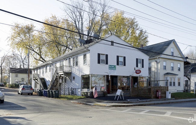
Property Record
650 Main St, Westbrook, ME 04092


Property Detail
650 Main St
WSBR-000033-000000-000026
Cumberland
Departmentstore
Maine
16
26
B and X Area of moderate flood hazard, usually the area between the limits of the 100-year and 500-year floods.
0.14 AC
2023
Outlying Cumberland County
2023
Portland/South Portland
002800
Portland-South Portland, ME
5,520 SF
NEARBY LISTINGS FOR SALE OR LEASE
-
-
View all Westbrook listings for sale on LoopNet.com
DEMOGRAPHICS near 650 Main St
1 mile
3 mile
5 mile
2025 Total Population
11,279
30,005
99,118
2030 Population
11,476
30,432
100,871
Pop Growth 2025-2030
+ 1.75%
+ 1.42%
+ 1.77%
Average Age
39
41
41
2025 Total Households
4,881
12,611
42,777
HH Growth 2025-2030
+ 1.93%
+ 1.62%
+ 1.80%
Median Household Inc
$89,349
$95,567
$95,489
Avg Household Size
2.20
2.30
2.20
2025 Avg HH Vehicles
2.00
2.00
2.00
Median Home Value
$393,073
$408,991
$457,649
Median Year Built
1964
1967
1963
Nearby Places
Map Layers
Map Styles
 Street
 Aerial
Transit
 Traffic
 Biking
Places
Listings with unknown addresses are not visible on the map
- Restaurants
- Banks
- Shops
- Fitness
- Groceries
PUBLIC TRANSPORTATION
COMMUTER RAIL
Drive
Walk
Distance
11 min
4.8 mi
AIRPORT
Portland International Jetport
Drive
Walk
Distance
Portland International Jetport
13 min
4.3 mi
Freight Ports
Portland, ME
Drive
Walk
Distance
Portland, ME
14 min
6.6 mi
SALE & LEASE HISTORY
LISTING DATE
SALE/LEASE

Sep 24, 2016
For Sale
Nearby Properties
Address
Land Use
TOTAL SIZE
Lot Size
Zoning
Address
Land Use
TOTAL SIZE
Lot Size
Zoning
86.50 AC
Address
Land Use
TOTAL SIZE
Lot Size
Zoning
84,636 SF
31.70 AC
22
Address
Land Use
TOTAL SIZE
Lot Size
Zoning
408.26 AC
Address
Land Use
TOTAL SIZE
Lot Size
Zoning
45.50 AC
Address
Land Use
TOTAL SIZE
Lot Size
Zoning
10.08 AC
Address
Land Use
TOTAL SIZE
Lot Size
Zoning
20.35 AC
Address
Land Use
TOTAL SIZE
Lot Size
Zoning
53.27 AC
22
Address
Land Use
TOTAL SIZE
Lot Size
Zoning
13.20 AC
I
Address
Land Use
TOTAL SIZE
Lot Size
Zoning
176,100 SF
9.71 AC
Z
Address
Land Use
TOTAL SIZE
Lot Size
Zoning
115,965 SF
6.27 AC
Z
Address
Land Use
TOTAL SIZE
Lot Size
Zoning
139,588 SF
0.85 AC
16
Address
Land Use
TOTAL SIZE
Lot Size
Zoning
17.95 AC
11
Address
Land Use
TOTAL SIZE
Lot Size
Zoning
152,378 SF
29.34 AC
21
Address
Land Use
TOTAL SIZE
Lot Size
Zoning
116,600 SF
12.37 AC
Z
Address
Land Use
TOTAL SIZE
Lot Size
Zoning
144,304 SF
10.01 AC
Z
Address
Land Use
TOTAL SIZE
Lot Size
Zoning
33.07 AC
Address
Land Use
TOTAL SIZE
Lot Size
Zoning
96,050 SF
12.90 AC
Z
Address
Land Use
TOTAL SIZE
Lot Size
Zoning
11.94 AC
Address
Land Use
TOTAL SIZE
Lot Size
Zoning
95,457 SF
5.25 AC
Z
Address
Land Use
TOTAL SIZE
Lot Size
Zoning
19.86 AC
Address
Land Use
TOTAL SIZE
Lot Size
Zoning
88,887 SF
21.44 AC
Address
Land Use
TOTAL SIZE
Lot Size
Zoning
11.96 AC
Address
Land Use
TOTAL SIZE
Lot Size
Zoning
90,848 SF
15.75 AC
11
Address
Land Use
TOTAL SIZE
Lot Size
Zoning
194,830 SF
19.33 AC
Address
Land Use
TOTAL SIZE
Lot Size
Zoning
83,509 SF
7.34 AC
17
Address
Land Use
TOTAL SIZE
Lot Size
Zoning
121,996 SF
24.53 AC
17
Address
Land Use
TOTAL SIZE
Lot Size
Zoning
5,340 SF
50 AC
Address
Land Use
TOTAL SIZE
Lot Size
Zoning
7.06 AC
17
Address
Land Use
TOTAL SIZE
Lot Size
Zoning
87,850 SF
23 AC
19
Address
Land Use
TOTAL SIZE
Lot Size
Zoning
65,920 SF
9.85 AC
The World's #1 Commercial Real Estate Marketplace
Connect with us
© 2026 CoStar Group
The information above has been obtained from sources believed reliable. While we do not doubt its accuracy we have not verified it and make no guarantee, warranty or representation about it. It is your responsibility to independently confirm its accuracy and completeness. Any projections, opinions, assumptions, or estimates used are for example only and do not represent the current or future performance of the property. The value of this transaction to you depends on tax and other factors which should be evaluated by your tax, financial, and legal advisors. You and your advisors should conduct a careful, independent investigation of the property to determine to your satisfaction the suitability of the property for your needs.