Property Record
650 State Route 15 S, Lake Hopatcong, NJ 07849
NEARBY LISTINGS FOR SALE OR LEASE
-
-
View all Lake Hopatcong listings for lease on LoopNet.com
Property Detail
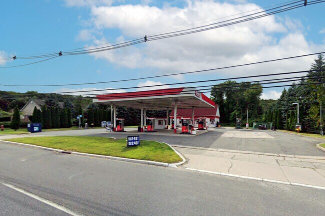
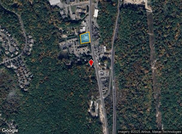
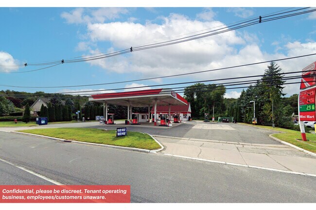
650 State Route 15 S
Newark, NJ-PA
FACILITY NAME: GETTY GAS STATION
14-00249-0000-00016
Morris
Commercialnec
New Jersey
2024
16
2025
0.91 AC
044702
Western Morris
864 SF
Northern New Jersey
DEMOGRAPHICS near 650 State Route 15 S
1 Mile
3 Mile
5 Mile
2024 Total Population
2,389
16,127
67,746
2029 Population
2,383
16,321
68,337
Pop Growth 2024-2029
(0.25%)
+ 1.20%
+ 0.87%
Average Age
41
43
43
2024 Total Households
860
6,433
26,454
HH Growth 2024-2029
(0.35%)
+ 1.21%
+ 0.91%
Median Household Inc
$123,943
$108,158
$103,658
Avg Household Size
2.70
2.50
2.50
2024 Avg HH Vehicles
2.00
2.00
2.00
Median Home Value
$558,605
$398,896
$350,726
Median Year Built
1988
1964
1968
Nearby Places
- Restaurants
- Banks
- Shops
- Fitness
- Groceries
PUBLIC TRANSPORTATION
COMMUTER RAIL
Mount Arlington (Montclair-Boonton Line - NJ Transit Commuter Rail (NJ Transit), Morris & Essex Morristown Line - NJ Transit Commuter Rail (NJ Transit))
DRIVE
WALK
Distance
Mount Arlington (Montclair-Boonton Line - NJ Transit Commuter Rail (NJ Transit), Morris & Essex Morristown Line - NJ Transit Commuter Rail (NJ Transit))
10 min
6.8 mi
Lake Hopatcong (Montclair-Boonton Line - NJ Transit Commuter Rail (NJ Transit), Morris & Essex Morristown Line - NJ Transit Commuter Rail (NJ Transit))
DRIVE
WALK
Distance
Lake Hopatcong (Montclair-Boonton Line - NJ Transit Commuter Rail (NJ Transit), Morris & Essex Morristown Line - NJ Transit Commuter Rail (NJ Transit))
13 min
7.2 mi
AIRPORT
Newark Liberty International
DRIVE
WALK
Distance
Newark Liberty International
47 min
35.3 mi
Freight Ports
Maher Terminal
DRIVE
WALK
Distance
Maher Terminal
50 min
35.8 mi
SALE & LEASE HISTORY
LISTING DATE
SALE/LEASE

May 19, 2023
For Lease
Nearby Properties
Address
Land Use
TOTAL SIZE
Lot Size
Zoning
Address
Land Use
TOTAL SIZE
Lot Size
Zoning
1,023 SF
143.31 AC
OR-3
Address
Land Use
TOTAL SIZE
Lot Size
Zoning
6,271.80 AC
R20A
Address
Land Use
TOTAL SIZE
Lot Size
Zoning
765.45 AC
M2
Address
Land Use
TOTAL SIZE
Lot Size
Zoning
362.82 AC
PRD1
Address
Land Use
TOTAL SIZE
Lot Size
Zoning
80,800 SF
8.23 AC
I
Address
Land Use
TOTAL SIZE
Lot Size
Zoning
10.76 AC
RG-5
Address
Land Use
TOTAL SIZE
Lot Size
Zoning
7.26 AC
A
Address
Land Use
TOTAL SIZE
Lot Size
Zoning
2,443 SF
6.73 AC
RAC2
Address
Land Use
TOTAL SIZE
Lot Size
Zoning
17.72 AC
C-2
Address
Land Use
TOTAL SIZE
Lot Size
Zoning
81,799 SF
4.51 AC
I
Address
Land Use
TOTAL SIZE
Lot Size
Zoning
17.90 AC
R-30
Address
Land Use
TOTAL SIZE
Lot Size
Zoning
11.27 AC
C-1
Address
Land Use
TOTAL SIZE
Lot Size
Zoning
23,950 SF
15.84 AC
RA40
Address
Land Use
TOTAL SIZE
Lot Size
Zoning
320 SF
3.45 AC
C-1
Address
Land Use
TOTAL SIZE
Lot Size
Zoning
21,525 SF
5.70 AC
C-2
Address
Land Use
TOTAL SIZE
Lot Size
Zoning
3.09 AC
C-2
Address
Land Use
TOTAL SIZE
Lot Size
Zoning
0.81 AC
R-30
Address
Land Use
TOTAL SIZE
Lot Size
Zoning
13,912 SF
9.62 AC
C-1
Address
Land Use
TOTAL SIZE
Lot Size
Zoning
1,800 SF
396.08 AC
RC
Address
Land Use
TOTAL SIZE
Lot Size
Zoning
14.68 AC
R1
Address
Land Use
TOTAL SIZE
Lot Size
Zoning
2,880 SF
1.08 AC
R-C
Address
Land Use
TOTAL SIZE
Lot Size
Zoning
86.83 AC
PRD1
Address
Land Use
TOTAL SIZE
Lot Size
Zoning
7,447 SF
3.90 AC
OR-3
Address
Land Use
TOTAL SIZE
Lot Size
Zoning
16,775 SF
34.51 AC
RC
Address
Land Use
TOTAL SIZE
Lot Size
Zoning
17,424 SF
1.53 AC
C-2
Address
Land Use
TOTAL SIZE
Lot Size
Zoning
11,000 SF
6.62 AC
C-2
Address
Land Use
TOTAL SIZE
Lot Size
Zoning
12,050 SF
1.05 AC
C-2
Address
Land Use
TOTAL SIZE
Lot Size
Zoning
1.49 AC
B1
Address
Land Use
TOTAL SIZE
Lot Size
Zoning
19,500 SF
4.75 AC
C-2
Address
Land Use
TOTAL SIZE
Lot Size
Zoning
20,334 SF
1.85 AC
C-2
The World's #1 Commercial Real Estate Marketplace
Connect with us
© 2025 CoStar Group
The information above has been obtained from sources believed reliable. While we do not doubt its accuracy we have not verified it and make no guarantee, warranty or representation about it. It is your responsibility to independently confirm its accuracy and completeness. Any projections, opinions, assumptions, or estimates used are for example only and do not represent the current or future performance of the property. The value of this transaction to you depends on tax and other factors which should be evaluated by your tax, financial, and legal advisors. You and your advisors should conduct a careful, independent investigation of the property to determine to your satisfaction the suitability of the property for your needs.