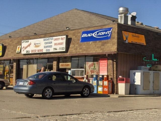
Property Record
650 Pointe Tremble Rd, Algonac, MI 48001

Property Detail
650 Pointe Tremble Rd
01-121-0047-050
PART OF LOT 1 TOWNCREST & PART OF LOTS 138, 139 & 140 BROADMOOR SUBD BEG N 73D 13M 40S W 15' FROM SELY COR OF LOT 140, TH N 73D 13M 40S W 100', TH N 17D 16M 20S E 160', TH S 73D 13M 40S E 100' TH S 17D 16M 20S W 160' TO BEG OWNED & OCC AS 1 PARCEL
Commercialnec
Saint Clair
GB
Michigan
AE The base floodplain where base flood elevations are provided. AE Zones are now used on new format FIRMs instead of A1-A30 Zones.
1,138
2025
0.37 AC
2025
St Clair & Lapeer Counties
649000
Detroit
3,792 SF
Detroit-Warren-Dearborn, MI
NEARBY LISTINGS FOR SALE OR LEASE
-
-
View all Algonac listings for sale on LoopNet.com
DEMOGRAPHICS near 650 Pointe Tremble Rd
1 mile
3 mile
5 mile
2025 Total Population
3,801
9,350
13,474
2030 Population
3,829
9,464
13,670
Pop Growth 2025-2030
+ 0.74%
+ 1.22%
+ 1.45%
Average Age
45
46
48
2025 Total Households
1,740
4,159
6,080
HH Growth 2025-2030
+ 0.75%
+ 1.27%
+ 1.58%
Median Household Inc
$52,696
$60,950
$70,993
Avg Household Size
2.20
2.20
2.20
2025 Avg HH Vehicles
2.00
2.00
2.00
Median Home Value
$184,540
$232,788
$270,735
Median Year Built
1970
1971
1971
Nearby Places
Map Layers
Map Styles
 Street
 Aerial
Layers
 Traffic
 Biking
Places
Listings with unknown addresses are not visible on the map
- Restaurants
- Banks
- Shops
- Fitness
- Groceries
SALE & LEASE HISTORY
LISTING DATE
SALE/LEASE

Nov 14, 2017
For Sale
Jul 31, 2017
For Sale
Feb 15, 2017
For Sale
Nearby Properties
Address
Land Use
TOTAL SIZE
Lot Size
Zoning
Address
Land Use
TOTAL SIZE
Lot Size
Zoning
69,306 SF
13.25 AC
C-3
Address
Land Use
TOTAL SIZE
Lot Size
Zoning
Address
Land Use
TOTAL SIZE
Lot Size
Zoning
Address
Land Use
TOTAL SIZE
Lot Size
Zoning
1,904 SF
98.63 AC
MHP
Address
Land Use
TOTAL SIZE
Lot Size
Zoning
48,036 SF
4.07 AC
CBD
Address
Land Use
TOTAL SIZE
Lot Size
Zoning
54,976 SF
6.83 AC
R-3
Address
Land Use
TOTAL SIZE
Lot Size
Zoning
9.71 AC
R-1
Address
Land Use
TOTAL SIZE
Lot Size
Zoning
68,193 SF
3.38 AC
R-2
Address
Land Use
TOTAL SIZE
Lot Size
Zoning
9,553 SF
0.55 AC
R-3
Address
Land Use
TOTAL SIZE
Lot Size
Zoning
492 AC
RS-1
Address
Land Use
TOTAL SIZE
Lot Size
Zoning
37,823 SF
1.77 AC
C-3
Address
Land Use
TOTAL SIZE
Lot Size
Zoning
11,052 SF
1.73 AC
CBD
Address
Land Use
TOTAL SIZE
Lot Size
Zoning
48,646 SF
2.95 AC
C-3
Address
Land Use
TOTAL SIZE
Lot Size
Zoning
466 SF
2.71 AC
C-2
Address
Land Use
TOTAL SIZE
Lot Size
Zoning
12,936 SF
1.47 AC
CBD
Address
Land Use
TOTAL SIZE
Lot Size
Zoning
4,023 SF
1.50 AC
GB
Address
Land Use
TOTAL SIZE
Lot Size
Zoning
53,430 SF
11.67 AC
C-3
Address
Land Use
TOTAL SIZE
Lot Size
Zoning
19,140 SF
2.72 AC
R-3
Address
Land Use
TOTAL SIZE
Lot Size
Zoning
42,914 SF
6.56 AC
C-3
Address
Land Use
TOTAL SIZE
Lot Size
Zoning
18,069 SF
2.73 AC
R-3
Address
Land Use
TOTAL SIZE
Lot Size
Zoning
5,160 SF
7.74 AC
RS-1
Address
Land Use
TOTAL SIZE
Lot Size
Zoning
7,100 SF
1.23 AC
CBD
Address
Land Use
TOTAL SIZE
Lot Size
Zoning
3,915 SF
8.29 AC
C-3
Address
Land Use
TOTAL SIZE
Lot Size
Zoning
3,216 SF
0.71 AC
CBD
Address
Land Use
TOTAL SIZE
Lot Size
Zoning
17,589 SF
3.27 AC
R-3
Address
Land Use
TOTAL SIZE
Lot Size
Zoning
4,556 SF
1.79 AC
GB
Address
Land Use
TOTAL SIZE
Lot Size
Zoning
4,088 SF
49.56 AC
R-1
Address
Land Use
TOTAL SIZE
Lot Size
Zoning
47,032 SF
3.78 AC
I-1
Address
Land Use
TOTAL SIZE
Lot Size
Zoning
0.39 AC
R-3
Address
Land Use
TOTAL SIZE
Lot Size
Zoning
3,123 SF
0.89 AC
GB
The World's #1 Commercial Real Estate Marketplace
Connect with us
© 2026 CoStar Group
The information above has been obtained from sources believed reliable. While we do not doubt its accuracy we have not verified it and make no guarantee, warranty or representation about it. It is your responsibility to independently confirm its accuracy and completeness. Any projections, opinions, assumptions, or estimates used are for example only and do not represent the current or future performance of the property. The value of this transaction to you depends on tax and other factors which should be evaluated by your tax, financial, and legal advisors. You and your advisors should conduct a careful, independent investigation of the property to determine to your satisfaction the suitability of the property for your needs.