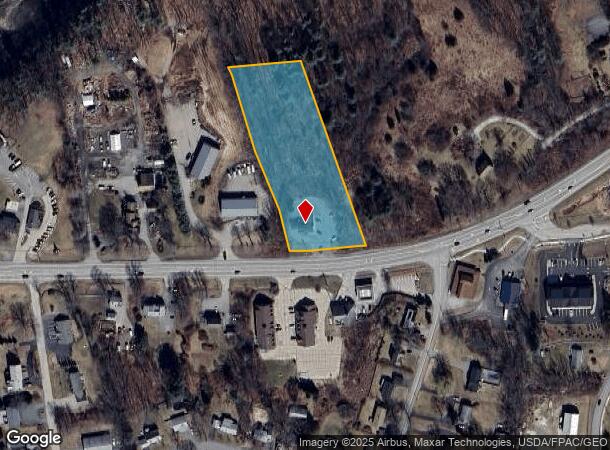
Property Record
650 Portsmouth Ave, Greenland, NH 03840
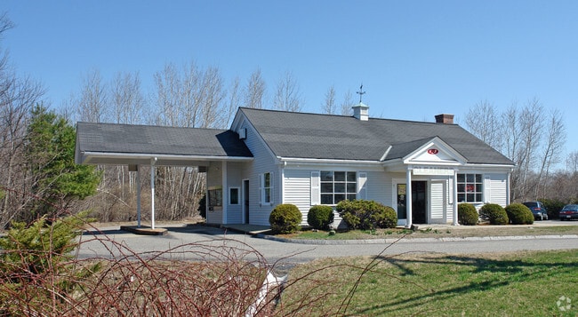
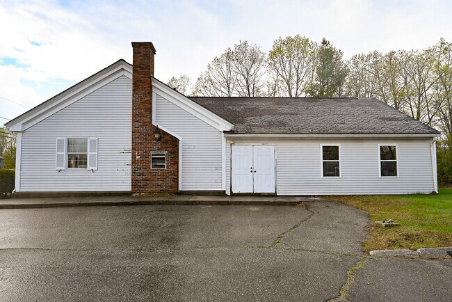
This Property Is For Sale
NEARBY LISTINGS FOR SALE OR LEASE
Property Detail
650 Portsmouth Ave
GRNL-000000-000017-000063-R000000
Rockingham
Departmentstore
New Hampshire
X
63
33015C0265F
2.28 AC
2024
Rockingham
2024
Boston
107500
Boston-Cambridge-Newton, MA-NH
2,040 SF
DEMOGRAPHICS near 650 Portsmouth Ave
1 Mile
3 Mile
5 Mile
2024 Total Population
1,515
11,684
39,509
2029 Population
1,579
12,140
41,181
Pop Growth 2024-2029
+ 4.22%
+ 3.90%
+ 4.23%
Average Age
44
44
44
2024 Total Households
589
4,801
16,977
HH Growth 2024-2029
+ 4.07%
+ 3.81%
+ 4.21%
Median Household Inc
$129,452
$120,342
$111,904
Avg Household Size
2.60
2.40
2.30
2024 Avg HH Vehicles
2.00
2.00
2.00
Median Home Value
$619,391
$556,452
$611,835
Median Year Built
1988
1984
1978
Nearby Places
- Restaurants
- Banks
- Shops
- Fitness
- Groceries
PUBLIC TRANSPORTATION
COMMUTER RAIL
Exeter (Downeaster - Amtrak)
DRIVE
WALK
Distance
Exeter (Downeaster - Amtrak)
18 min
8.9 mi
AIRPORT
Portsmouth International at Pease
DRIVE
WALK
Distance
Portsmouth International at Pease
11 min
5.1 mi
Freight Ports
Port of Boston
DRIVE
WALK
Distance
Port of Boston
76 min
57.9 mi
Nearby Properties
Address
Land Use
TOTAL SIZE
Lot Size
Zoning
Address
Land Use
TOTAL SIZE
Lot Size
Zoning
35.53 AC
GA/MH
Address
Land Use
TOTAL SIZE
Lot Size
Zoning
28.05 AC
GA/MH
Address
Land Use
TOTAL SIZE
Lot Size
Zoning
114,194 SF
G1
Address
Land Use
TOTAL SIZE
Lot Size
Zoning
33.39 AC
IND
Address
Land Use
TOTAL SIZE
Lot Size
Zoning
25.08 AC
NRP
Address
Land Use
TOTAL SIZE
Lot Size
Zoning
190,444 SF
20.38 AC
G1
Address
Land Use
TOTAL SIZE
Lot Size
Zoning
7.16 AC
GA/MH
Address
Land Use
TOTAL SIZE
Lot Size
Zoning
72,193 SF
G1
Address
Land Use
TOTAL SIZE
Lot Size
Zoning
87,917 SF
29.26 AC
RA
Address
Land Use
TOTAL SIZE
Lot Size
Zoning
72,694 SF
36.70 AC
I
Address
Land Use
TOTAL SIZE
Lot Size
Zoning
85,152 SF
13.04 AC
G1
Address
Land Use
TOTAL SIZE
Lot Size
Zoning
108,116 SF
18.48 AC
IND
Address
Land Use
TOTAL SIZE
Lot Size
Zoning
207,279 SF
33.07 AC
I
Address
Land Use
TOTAL SIZE
Lot Size
Zoning
132,784 SF
22.32 AC
IND
Address
Land Use
TOTAL SIZE
Lot Size
Zoning
107,657 SF
8.67 AC
IND
Address
Land Use
TOTAL SIZE
Lot Size
Zoning
Address
Land Use
TOTAL SIZE
Lot Size
Zoning
134,204 SF
G1
Address
Land Use
TOTAL SIZE
Lot Size
Zoning
24,810 SF
10.75 AC
I
Address
Land Use
TOTAL SIZE
Lot Size
Zoning
1,740 SF
67.09 AC
GA/MH
Address
Land Use
TOTAL SIZE
Lot Size
Zoning
196,424 SF
15.25 AC
I
Address
Land Use
TOTAL SIZE
Lot Size
Zoning
64.57 AC
I
Address
Land Use
TOTAL SIZE
Lot Size
Zoning
3.80 AC
G1
Address
Land Use
TOTAL SIZE
Lot Size
Zoning
4.79 AC
I
Address
Land Use
TOTAL SIZE
Lot Size
Zoning
83,021 SF
3.54 AC
RES
Address
Land Use
TOTAL SIZE
Lot Size
Zoning
33,716 SF
G1
Address
Land Use
TOTAL SIZE
Lot Size
Zoning
34,359 SF
10.15 AC
COM
Address
Land Use
TOTAL SIZE
Lot Size
Zoning
33,870 SF
12.77 AC
OR
Address
Land Use
TOTAL SIZE
Lot Size
Zoning
7,350 SF
100 AC
NRP
Address
Land Use
TOTAL SIZE
Lot Size
Zoning
62,322 SF
5.55 AC
I
Address
Land Use
TOTAL SIZE
Lot Size
Zoning
3.51 AC
G1
The World's #1 Commercial Real Estate Marketplace
Connect with us
© 2025 CoStar Group
The information above has been obtained from sources believed reliable. While we do not doubt its accuracy we have not verified it and make no guarantee, warranty or representation about it. It is your responsibility to independently confirm its accuracy and completeness. Any projections, opinions, assumptions, or estimates used are for example only and do not represent the current or future performance of the property. The value of this transaction to you depends on tax and other factors which should be evaluated by your tax, financial, and legal advisors. You and your advisors should conduct a careful, independent investigation of the property to determine to your satisfaction the suitability of the property for your needs.