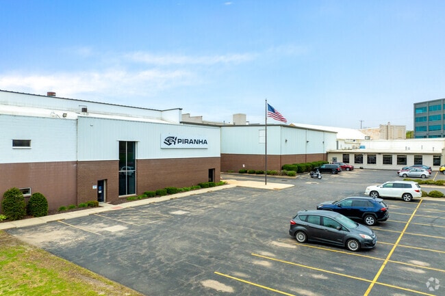
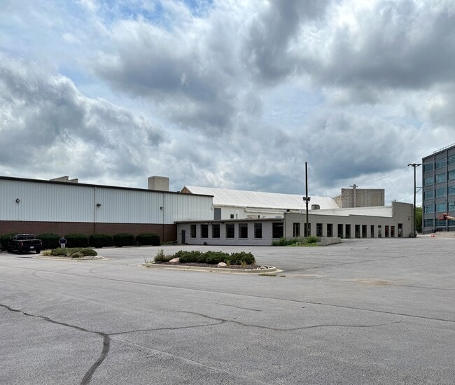
Property Record
650 Race St, Rockford, IL 61101


Current Lease Availabilities
NEARBY LISTINGS FOR SALE OR LEASE
Property Detail
650 Race St
Chicago
West Rockford
Rockford, IL
BEG SW COR LT 2 BLK 1 WEST ROCKFORD THN TO S LN RR TH SE ALG RR TO VAC WYMAN ST SE 263.79 FT NE 59.81 FT N 22.92FT E APPROX 22.27 FT TO W LN ROCK RIVE
11-27-230-024
Winnebago
Industrialgeneral
Illinois
2024
2
2024
12.56 AC
002800
I-39 Cor/Winnebago Cy
210,980 SF
DEMOGRAPHICS near 650 Race St
1 Mile
3 Mile
5 Mile
2024 Total Population
12,248
86,581
150,991
2029 Population
12,346
86,206
149,545
Pop Growth 2024-2029
+ 0.80%
(0.43%)
(0.96%)
Average Age
37
37
39
2024 Total Households
5,007
34,252
60,496
HH Growth 2024-2029
+ 0.74%
(0.53%)
(1.03%)
Median Household Inc
$21,392
$36,947
$44,041
Avg Household Size
2.20
2.40
2.40
2024 Avg HH Vehicles
1.00
1.00
2.00
Median Home Value
$61,081
$72,828
$98,176
Median Year Built
1949
1951
1958
Nearby Places
Map Layers
Map Styles
 Street
 Aerial
- Restaurants
- Banks
- Shops
- Fitness
- Groceries
PUBLIC TRANSPORTATION
AIRPORT
Chicago/Rockford International
DRIVE
WALK
Distance
Chicago/Rockford International
17 min
8.0 mi
Freight Ports
Port Milwaukee
DRIVE
WALK
Distance
Port Milwaukee
115 min
94.3 mi
Nearby Properties
Address
Land Use
TOTAL SIZE
Lot Size
Zoning
Address
Land Use
TOTAL SIZE
Lot Size
Zoning
1,456,216 SF
103.10 AC
I1
Address
Land Use
TOTAL SIZE
Lot Size
Zoning
201,507 SF
C4
Address
Land Use
TOTAL SIZE
Lot Size
Zoning
13,308 SF
19.30 AC
I2
Address
Land Use
TOTAL SIZE
Lot Size
Zoning
115,095 SF
0.25 AC
C4
Address
Land Use
TOTAL SIZE
Lot Size
Zoning
117,360 SF
1.52 AC
R4
Address
Land Use
TOTAL SIZE
Lot Size
Zoning
111,491 SF
0.32 AC
C4
Address
Land Use
TOTAL SIZE
Lot Size
Zoning
79,318 SF
1.55 AC
C4
Address
Land Use
TOTAL SIZE
Lot Size
Zoning
43.23 AC
I1
Address
Land Use
TOTAL SIZE
Lot Size
Zoning
192,575 SF
46.19 AC
I1
Address
Land Use
TOTAL SIZE
Lot Size
Zoning
238,884 SF
15.96 AC
R3
Address
Land Use
TOTAL SIZE
Lot Size
Zoning
645,384 SF
25.22 AC
I1
Address
Land Use
TOTAL SIZE
Lot Size
Zoning
113,175 SF
5 AC
R3
Address
Land Use
TOTAL SIZE
Lot Size
Zoning
2,975 SF
5.42 AC
I2
Address
Land Use
TOTAL SIZE
Lot Size
Zoning
150,426 SF
9.25 AC
C3
Address
Land Use
TOTAL SIZE
Lot Size
Zoning
108,233 SF
0.34 AC
C4
Address
Land Use
TOTAL SIZE
Lot Size
Zoning
158,754 SF
0.91 AC
C4
Address
Land Use
TOTAL SIZE
Lot Size
Zoning
39,184 SF
3.10 AC
C2
Address
Land Use
TOTAL SIZE
Lot Size
Zoning
77,936 SF
1.71 AC
C4
Address
Land Use
TOTAL SIZE
Lot Size
Zoning
10,970 SF
26.80 AC
R2
Address
Land Use
TOTAL SIZE
Lot Size
Zoning
151,360 SF
8.13 AC
I1
Address
Land Use
TOTAL SIZE
Lot Size
Zoning
239,792 SF
0.25 AC
C4
Address
Land Use
TOTAL SIZE
Lot Size
Zoning
85,575 SF
10.29 AC
C2
Address
Land Use
TOTAL SIZE
Lot Size
Zoning
299,238 SF
18.84 AC
I2
Address
Land Use
TOTAL SIZE
Lot Size
Zoning
144,088 SF
12.01 AC
I1
Address
Land Use
TOTAL SIZE
Lot Size
Zoning
137,546 SF
0.71 AC
C4
Address
Land Use
TOTAL SIZE
Lot Size
Zoning
103,365 SF
3 AC
C2
Address
Land Use
TOTAL SIZE
Lot Size
Zoning
79,642 SF
10.56 AC
I1
Address
Land Use
TOTAL SIZE
Lot Size
Zoning
118,780 SF
30.47 AC
I2
Address
Land Use
TOTAL SIZE
Lot Size
Zoning
119,204 SF
3 AC
R4
Address
Land Use
TOTAL SIZE
Lot Size
Zoning
191,265 SF
9.67 AC
I1
The World's #1 Commercial Real Estate Marketplace
Connect with us
© 2025 CoStar Group
The information above has been obtained from sources believed reliable. While we do not doubt its accuracy we have not verified it and make no guarantee, warranty or representation about it. It is your responsibility to independently confirm its accuracy and completeness. Any projections, opinions, assumptions, or estimates used are for example only and do not represent the current or future performance of the property. The value of this transaction to you depends on tax and other factors which should be evaluated by your tax, financial, and legal advisors. You and your advisors should conduct a careful, independent investigation of the property to determine to your satisfaction the suitability of the property for your needs.