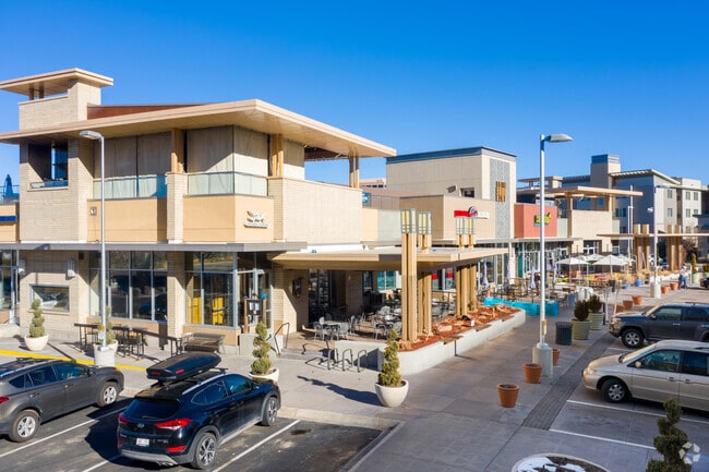
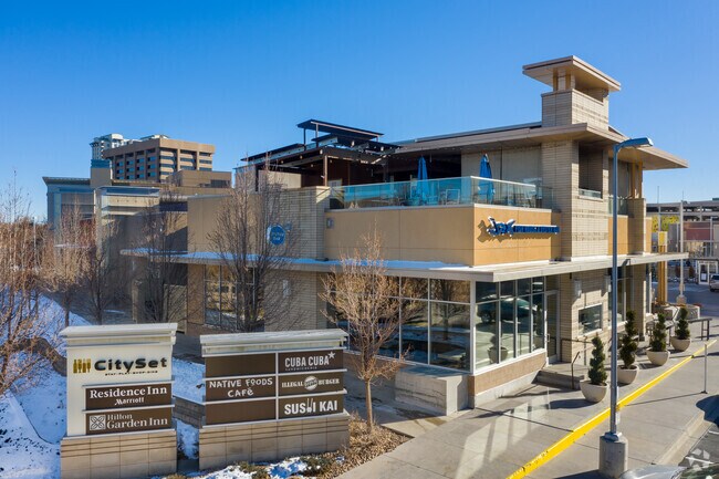
Property Record
650 S Colorado Blvd, Denver, CO 80246
NEARBY LISTINGS FOR SALE OR LEASE
Property Detail
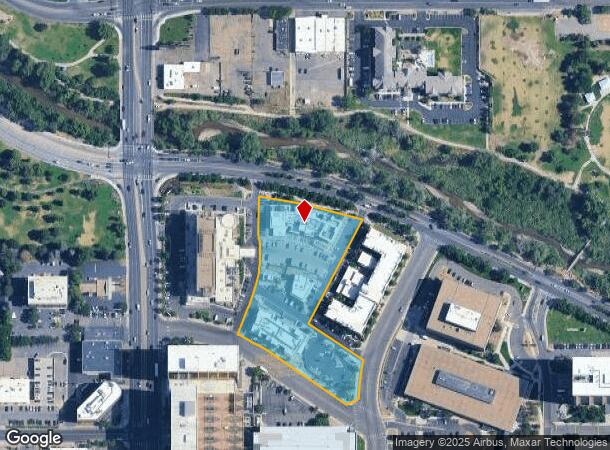
650 S Colorado Blvd
Denver-Aurora-Lakewood, CO
Sonley 1St Replat
1973-18-2-17-001
SUBDIVISIONCD 056609 SUBDIVISIONNAME SONLEY 1ST REPLAT BLOCK 000 LOT 002 LOT 2 SONLEY 1ST REPLAT
Restaurantbuilding
Arapahoe
X
Colorado
0800460204H
002,2
2023
3.09 AC
2024
Colorado Bl/Cherry Ck
004952
Denver
88,362 SF
DEMOGRAPHICS near 650 S Colorado Blvd
1 Mile
3 Mile
5 Mile
2024 Total Population
23,698
216,383
546,113
2029 Population
24,190
219,116
553,502
Pop Growth 2024-2029
+ 2.08%
+ 1.26%
+ 1.35%
Average Age
40
39
38
2024 Total Households
13,199
109,690
257,470
HH Growth 2024-2029
+ 2.13%
+ 1.19%
+ 1.41%
Median Household Inc
$80,726
$86,097
$78,550
Avg Household Size
1.80
1.90
2.00
2024 Avg HH Vehicles
1.00
1.00
1.00
Median Home Value
$875,082
$744,722
$630,222
Median Year Built
1982
1968
1973
Nearby Places
- Restaurants
- Banks
- Shops
- Fitness
- Groceries
PUBLIC TRANSPORTATION
COMMUTER RAIL
Denver (California Zephyr - Amtrak)
DRIVE
WALK
Distance
Denver (California Zephyr - Amtrak)
14 min
5.5 mi
Union Station: Lodo-Coors Field-16Th Street Mall (C Line - Denver Regional Transportation District Light Rail (TheRide), E Line - Denver Regional Transportation District Light Rail (TheRide), W Line - Denver Regional Transportation District Light Rail (TheRide))
DRIVE
WALK
Distance
Union Station: Lodo-Coors Field-16Th Street Mall (C Line - Denver Regional Transportation District Light Rail (TheRide), E Line - Denver Regional Transportation District Light Rail (TheRide), W Line - Denver Regional Transportation District Light Rail (TheRide))
13 min
5.6 mi
AIRPORT
Denver International
DRIVE
WALK
Distance
Denver International
35 min
24.1 mi
Freight Ports
Tulsa Port Of Catoosa
DRIVE
WALK
Distance
Tulsa Port Of Catoosa
732 min
706.8 mi
SALE & LEASE HISTORY
LISTING DATE
SALE/LEASE

Feb 15, 2018
For Lease
Dec 21, 2018
For Lease
Nearby Properties
Address
Land Use
TOTAL SIZE
Lot Size
Zoning
Address
Land Use
TOTAL SIZE
Lot Size
Zoning
856,519 SF
10.04 AC
B-3
Address
Land Use
TOTAL SIZE
Lot Size
Zoning
1,137,044 SF
35.49 AC
CMP-EI
Address
Land Use
TOTAL SIZE
Lot Size
Zoning
579,102 SF
7.47 AC
H-1-A
Address
Land Use
TOTAL SIZE
Lot Size
Zoning
252,992 SF
11.76 AC
B-3
Address
Land Use
TOTAL SIZE
Lot Size
Zoning
550,760 SF
13.25 AC
CMP-EI
Address
Land Use
TOTAL SIZE
Lot Size
Zoning
197,212 SF
0.56 AC
C-CCN-5
Address
Land Use
TOTAL SIZE
Lot Size
Zoning
543,122 SF
13.43 AC
CMP-EI
Address
Land Use
TOTAL SIZE
Lot Size
Zoning
603,377 SF
9.25 AC
H-1-A
Address
Land Use
TOTAL SIZE
Lot Size
Zoning
283,322 SF
0.99 AC
C-MX-16
Address
Land Use
TOTAL SIZE
Lot Size
Zoning
152,415 SF
1.09 AC
C-CCN
Address
Land Use
TOTAL SIZE
Lot Size
Zoning
453,280 SF
5.45 AC
B-4
Address
Land Use
TOTAL SIZE
Lot Size
Zoning
416,096 SF
5.20 AC
C-MX-20
Address
Land Use
TOTAL SIZE
Lot Size
Zoning
240,545 SF
2.35 AC
C-MX-20
Address
Land Use
TOTAL SIZE
Lot Size
Zoning
505,731 SF
2.46 AC
G-MU-20
Address
Land Use
TOTAL SIZE
Lot Size
Zoning
281,456 SF
36.55 AC
R-5
Address
Land Use
TOTAL SIZE
Lot Size
Zoning
97,530 SF
0.43 AC
C-CCN-7
Address
Land Use
TOTAL SIZE
Lot Size
Zoning
185,689 SF
2.50 AC
C-CCN-8
Address
Land Use
TOTAL SIZE
Lot Size
Zoning
83,591 SF
0.42 AC
C-CCN-7
Address
Land Use
TOTAL SIZE
Lot Size
Zoning
41,116 SF
3.51 AC
G-TR
Address
Land Use
TOTAL SIZE
Lot Size
Zoning
174,244 SF
17.26 AC
E-SU-DX
Address
Land Use
TOTAL SIZE
Lot Size
Zoning
362,988 SF
4.71 AC
T-MU-30
Address
Land Use
TOTAL SIZE
Lot Size
Zoning
169,311 SF
0.47 AC
C-CCN-8
Address
Land Use
TOTAL SIZE
Lot Size
Zoning
178,107 SF
2.28 AC
C-CCN-8
Address
Land Use
TOTAL SIZE
Lot Size
Zoning
191,192 SF
10.16 AC
E-SU-D
Address
Land Use
TOTAL SIZE
Lot Size
Zoning
1,054,198 SF
6.62 AC
PUD
Address
Land Use
TOTAL SIZE
Lot Size
Zoning
379,927 SF
8.06 AC
PUD
Address
Land Use
TOTAL SIZE
Lot Size
Zoning
157,800 SF
2.12 AC
C-CCN-8
Address
Land Use
TOTAL SIZE
Lot Size
Zoning
477,508 SF
79.66 AC
OS-A
Address
Land Use
TOTAL SIZE
Lot Size
Zoning
160,631 SF
2.76 AC
C-CCN-8
Address
Land Use
TOTAL SIZE
Lot Size
Zoning
134,297 SF
1.54 AC
C-MX-5
The World's #1 Commercial Real Estate Marketplace
Connect with us
© 2025 CoStar Group
The information above has been obtained from sources believed reliable. While we do not doubt its accuracy we have not verified it and make no guarantee, warranty or representation about it. It is your responsibility to independently confirm its accuracy and completeness. Any projections, opinions, assumptions, or estimates used are for example only and do not represent the current or future performance of the property. The value of this transaction to you depends on tax and other factors which should be evaluated by your tax, financial, and legal advisors. You and your advisors should conduct a careful, independent investigation of the property to determine to your satisfaction the suitability of the property for your needs.