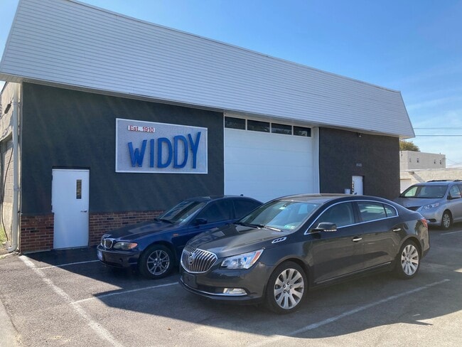
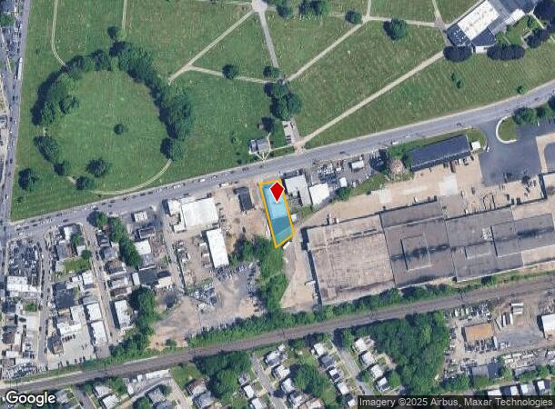
Property Record
6500 Baltimore Ave, Lansdowne, PA 19050
NEARBY LISTINGS FOR SALE OR LEASE
Property Detail
6500 Baltimore Ave
16-02-00130-00
2 STY BLDG 70 X 176
Warehouse
Delaware
X
Pennsylvania
42045C0109F
0.28 AC
2024
Delaware County
2025
Philadelphia
400302
Philadelphia-Camden-Wilmington, PA-NJ-DE-MD
14,080 SF
DEMOGRAPHICS near 6500 Baltimore Ave
1 Mile
3 Mile
5 Mile
2024 Total Population
34,789
354,158
772,812
2029 Population
34,088
345,884
757,523
Pop Growth 2024-2029
(2.02%)
(2.34%)
(1.98%)
Average Age
38
38
38
2024 Total Households
12,833
137,178
320,376
HH Growth 2024-2029
(2.16%)
(2.53%)
(2.26%)
Median Household Inc
$43,021
$45,739
$61,632
Avg Household Size
2.60
2.40
2.30
2024 Avg HH Vehicles
1.00
1.00
1.00
Median Home Value
$149,568
$150,947
$245,414
Median Year Built
1946
1948
1949
Nearby Places
Map Layers
Map Styles
 Street
 Aerial
- Restaurants
- Banks
- Shops
- Fitness
- Groceries
PUBLIC TRANSPORTATION
TRANSIT/SUBWAY
Angora Loop (Route 34 - Southeastern Pennsylvania Transportation Authority Rapid Transit (SEPTA Subway & Trolley))
DRIVE
WALK
Distance
Angora Loop (Route 34 - Southeastern Pennsylvania Transportation Authority Rapid Transit (SEPTA Subway & Trolley))
1 min
7 min
0.4 mi
Baltimore Avenue And 60Th Street (Route 34 - Southeastern Pennsylvania Transportation Authority Rapid Transit (SEPTA Subway & Trolley))
DRIVE
WALK
Distance
Baltimore Avenue And 60Th Street (Route 34 - Southeastern Pennsylvania Transportation Authority Rapid Transit (SEPTA Subway & Trolley))
1 min
10 min
0.6 mi
Baltimore Avenue And 59Th Street (Route 34 - Southeastern Pennsylvania Transportation Authority Rapid Transit (SEPTA Subway & Trolley))
DRIVE
WALK
Distance
Baltimore Avenue And 59Th Street (Route 34 - Southeastern Pennsylvania Transportation Authority Rapid Transit (SEPTA Subway & Trolley))
1 min
13 min
0.7 mi
Baltimore Avenue And 58Th Street (Route 34 - Southeastern Pennsylvania Transportation Authority Rapid Transit (SEPTA Subway & Trolley))
DRIVE
WALK
Distance
Baltimore Avenue And 58Th Street (Route 34 - Southeastern Pennsylvania Transportation Authority Rapid Transit (SEPTA Subway & Trolley))
2 min
15 min
0.8 mi
Baltimore Avenue And 57Th Street (Route 34 - Southeastern Pennsylvania Transportation Authority Rapid Transit (SEPTA Subway & Trolley))
DRIVE
WALK
Distance
Baltimore Avenue And 57Th Street (Route 34 - Southeastern Pennsylvania Transportation Authority Rapid Transit (SEPTA Subway & Trolley))
2 min
17 min
0.9 mi
COMMUTER RAIL
Fernwood-Yeadon (R3 - Southeastern Pennsylvania Transportation Authority Regional Rail (SEPTA Regional Rail))
DRIVE
WALK
Distance
Fernwood-Yeadon (R3 - Southeastern Pennsylvania Transportation Authority Regional Rail (SEPTA Regional Rail))
1 min
5 min
0.3 mi
Angora (R3 - Southeastern Pennsylvania Transportation Authority Regional Rail (SEPTA Regional Rail))
DRIVE
WALK
Distance
Angora (R3 - Southeastern Pennsylvania Transportation Authority Regional Rail (SEPTA Regional Rail))
2 min
17 min
0.9 mi
AIRPORT
Philadelphia International
DRIVE
WALK
Distance
Philadelphia International
16 min
6.6 mi
Freight Ports
South Jersey Port
DRIVE
WALK
Distance
South Jersey Port
22 min
10.3 mi
SALE & LEASE HISTORY
LISTING DATE
SALE/LEASE

Oct 17, 2023
For Sale
May 05, 2023
For Lease
Nearby Properties
Address
Land Use
TOTAL SIZE
Lot Size
Zoning
Address
Land Use
TOTAL SIZE
Lot Size
Zoning
696,920 SF
10.55 AC
SPINS
Address
Land Use
TOTAL SIZE
Lot Size
Zoning
685,000 SF
47.69 AC
CMX3
Address
Land Use
TOTAL SIZE
Lot Size
Zoning
239,760 SF
5.51 AC
SPINS
Address
Land Use
TOTAL SIZE
Lot Size
Zoning
158,496 SF
Address
Land Use
TOTAL SIZE
Lot Size
Zoning
269,171 SF
2.64 AC
SPINS
Address
Land Use
TOTAL SIZE
Lot Size
Zoning
910,000 SF
70 AC
I2
Address
Land Use
TOTAL SIZE
Lot Size
Zoning
Address
Land Use
TOTAL SIZE
Lot Size
Zoning
413,808 SF
0.76 AC
RM4
Address
Land Use
TOTAL SIZE
Lot Size
Zoning
374,706 SF
21.26 AC
CMX3
Address
Land Use
TOTAL SIZE
Lot Size
Zoning
175,069 SF
2.20 AC
CMX3
Address
Land Use
TOTAL SIZE
Lot Size
Zoning
206,365 SF
3.40 AC
RSA5
Address
Land Use
TOTAL SIZE
Lot Size
Zoning
500,000 SF
3.50 AC
SPINS
Address
Land Use
TOTAL SIZE
Lot Size
Zoning
76,614 SF
1.53 AC
CMX3
Address
Land Use
TOTAL SIZE
Lot Size
Zoning
1,600 SF
177.07 AC
SPPOA
Address
Land Use
TOTAL SIZE
Lot Size
Zoning
97,810 SF
40 AC
I3
Address
Land Use
TOTAL SIZE
Lot Size
Zoning
154,555 SF
1.42 AC
SPINS
Address
Land Use
TOTAL SIZE
Lot Size
Zoning
232,225 SF
0.86 AC
CMX4
Address
Land Use
TOTAL SIZE
Lot Size
Zoning
461,834 SF
4.73 AC
CMX3
Address
Land Use
TOTAL SIZE
Lot Size
Zoning
304,000 SF
1.58 AC
CMX4
Address
Land Use
TOTAL SIZE
Lot Size
Zoning
374,105 SF
5.63 AC
CMX3
Address
Land Use
TOTAL SIZE
Lot Size
Zoning
448,864 SF
32.89 AC
Address
Land Use
TOTAL SIZE
Lot Size
Zoning
268,381 SF
1 AC
CMX4
Address
Land Use
TOTAL SIZE
Lot Size
Zoning
343,158 SF
12 AC
CMX4
Address
Land Use
TOTAL SIZE
Lot Size
Zoning
1,935,584 SF
11.11 AC
ICMX
Address
Land Use
TOTAL SIZE
Lot Size
Zoning
323,248 SF
2.90 AC
SPAIR
Address
Land Use
TOTAL SIZE
Lot Size
Zoning
144,963 SF
1.52 AC
I2
Address
Land Use
TOTAL SIZE
Lot Size
Zoning
132,048 SF
1.01 AC
CMX4
Address
Land Use
TOTAL SIZE
Lot Size
Zoning
475,984 SF
5.74 AC
ICMX
Address
Land Use
TOTAL SIZE
Lot Size
Zoning
190,150 SF
0.77 AC
RM1
Address
Land Use
TOTAL SIZE
Lot Size
Zoning
1.65 AC
CMX3
The World's #1 Commercial Real Estate Marketplace
Connect with us
© 2025 CoStar Group
The information above has been obtained from sources believed reliable. While we do not doubt its accuracy we have not verified it and make no guarantee, warranty or representation about it. It is your responsibility to independently confirm its accuracy and completeness. Any projections, opinions, assumptions, or estimates used are for example only and do not represent the current or future performance of the property. The value of this transaction to you depends on tax and other factors which should be evaluated by your tax, financial, and legal advisors. You and your advisors should conduct a careful, independent investigation of the property to determine to your satisfaction the suitability of the property for your needs.